Capture Calif

Capture California

What is a YOLT? Well, you may have heard the term YOLO. Gary and Sherri think we can live again, not as James Bond, but as being reborn. Consequently, we are having fun in our life, after all, You Only Live Twice.

Wednesday, October 10, 2012

Adventure: 114- Family Adventure


Capture California, the Game-2012
Adventure: 114- Family Adventure
Team: Thing One, Thing Two
Date:  October 10, 2012
Description: All summer long, the Cat in the Hat has been doling Kid's Adventure Journal's out like candy. It has places for kids to draw adventures, word searches, and the most important thing of all, stickers!!! There are also Critter questions posted around the REI store to engage the little one's minds while in the middle of a summer break. (Don't ask me why all the questions are positioned above a kid's height) I saved this kid's adventure journal so I would have one to take a picture with, however, it will probably go back into my vest pocket and will be handed out when a child with too much energy needs a distraction. :)

Adventure: 051, Site 188 - Rainbow Trout Species Identified

 Capture California, the Game-2012


Adventure: 051,site 188 - Rainbow Trout Species Identified
California Landmark ID: 970
Team: Thing One, Thing Two
Date:  September 30, 2012
Description: As the Cat in the Hat was looking at the Redwood Regional Park Map for her trail run she noticed a description of a California Historical Marker. Making note of it she decided to find it at the end of the run since it seemed to be nearby. After running an additional 20 minutes all in pursuit of the trail marker she decided to give up and head back to the car. Lo and behold right next to the her parked car was.... the historical marker, doh!
Historical Marker 970 is where the Rainbow Trout Species was first identified. That was a pretty neat factoid to learn about this park that the Cat in the Hat had only started to explore recently. All along the stream bed were signs about the restoration of trout and treating the area with care. They were put into perspective  with this landmark. On the bridge crossing the stream by the marker was a fishladder. So much cool stuff in this park!


NO. 970 RAINBOW TROUT SPECIES IDENTIFIED - The naming of the Rainbow Trout species was based on fish taken from the San Leandro Creek drainage. In 1855, Dr. W. P. Gibbons, founder of the California Academy of Sciences, was given three specimens obtained from the creek. He described and assigned them the scientific name Salmo iridia. Rainbow Trout are now worldwide in distribution and are a highly prized game fish.
Location:  50 yards past Redwood Gate entrance kiosk, Redwood Regional Park, Oakland

Adventure: 03- Frolic on the Beach


Capture California, the Game-2012
Adventure: 03- Frolic on the Beach
Team: Thing One, Thing Two
Date:  September 30, 2012
Description:

What better way to celebrate a 30th birthday than to frolic on the beach? This was the first time that the Cat in the Hat had been to the lovely Bodega Bay. With all her friends around her and the waves crashing in the distance nothing seemed more natural than to run into the waves dancing and waving a Capture California flag around. And of course the next step after frolicking was to go barefoot running to the most amazing tide pool ever at the end of the beach. Unfortunately we already submitted our tidepool adventure! 

Sunday, October 7, 2012

Adventure 015 – Draw A Volcano

Capture California, the Game-2012
Adventure: 015 – Draw A Volcano
Team: Thing One, Thing Two
Date:  October 7, 2012
Description:


Last year we learned a lot about volcano's by visiting the Kom Yah-Man-Yee Visitor Center in Lassen Volcanic National park. It is a place which we hope to explore some more. Actually we planned to explore it this year and just flat out ran out of time, plus the fires up there got in the way. But there is always next year. One tid-bit is that we found out the place where we will be staying next week sit smack dab on top of a shield volcano.


(Enjoy the drawings :-)


Adventure 051, Site 172 – Old Fresno County Courthouse

Capture California, the Game-2012
Adventure: 051, Site 172 – Old Fresno County Courthouse
E Clampus Vitsus Sign and a Local Sign

Team: Thing One, Thing Two


Date:  October 7, 2012
Location:
Latitude: 36° 44.15′ N
Longitude: 119° 47.383′ W
Address: 1100 Van Ness Avenue, Fresno CA

Description:

Ever since we discovered that we could submit multiple historical sites to Capture California, Thing Two has been browsing a book we have of Fresno historical places. One place which she keeps coming back to is the old Fresno County Courthouse. Its sister courthouse is still standing in Merced, but in 1966 Fresno's was torn down when the new and modern courthouse was built. Thing Two has acquired a fascination with this old courthouse. So today, we went back to the courthouse site to find a plaque or something which would commemorate it. Unfortunately, the plaque has been stolen—the rock where the plaque was,  can be seen.

Thing Two had a lot to think about when it came to the Fresno County Court House. After the move from Millerton in 1875, we had a gorgeous court house. The picture reminded you of our state capital. In the pictures of historical downtown Fresno, the Court house seemed to anchor the town. Many building had already been torn down that were the Victorian in nature. The courthouse remained connecting us to the pioneer days of Fresno. In 1962 our County Board of Supervisors voted to tear down the courthouse. A citizen group fought the action to tear down the court house. Even with public support against the supervisors’ decision, they refused to listen to their constituents. In the next election all supervisors up for election were voted out of office. But we lost a gorgeous building and a bit of our past. The building was deemed to be a danger because of earthquakes so it would only take 2 hours to demolish this building. It took over 8 hours to tear down the courthouse.


References:


Overall Landmark References:


Saturday, October 6, 2012

Adventure 051, Site 173 – Fort Tejon

Capture California, the Game-2012
Adventure: 051, Site 173 – Fort Tejon
California Landmark Number: 129
National Registry ID: 1971000140

Team: Thing One, Thing Two
Date:  October 6, 2012
Location:
Latitude: 34° 52.394′ N
Longitude: 118° 53.73′ W
Address: Fort Tejón State Historic Park

Description:

Thing One and Thing Two were on their way back from visiting their daughter, when they saw Fot Tejon's California Landmark sign. Being suckers these days for any historical site, they found the plaque and took their pictures. But that is not all—they also found out a few things about Fort Tejon.

How do camels and Fresno meet into this adventure some 40 miles south of Bakersfield? First, Jefferson Davis had established the Army Camel Corp to aid in patrolling the Southwest. The trail went from Texas to Fort Tejon with the Camel Corp being quartered at Fort Tejon. It turns out that the camels were ill-suited for the Southwest so they never became part of Amry operations.

So how does Fresno come into play? Fort Tejon was being established to help control Indian relations. There was a reservation within 20 miles of Fort Tejon. But the Army already had a station at Fort Miller, near Fresno. The Army wanted out of there and thought that Fort Tejon would be a better place for them. So they moved out of the Fresno area to Fort Tejon.


NO. 129 FORT TEJÓN -This military post was established by the United States Army on June 24, 1854, to suppress stock rustling and protect the Indians in the San Joaquin Valley. Camels for transportation were introduced here in 1858. As regimental headquarters of the First Dragoons, Fort Tejón was an important military, social, and political center - it was abandoned September 11, 1864.
Location: Fort Tejón State Historic Park, on Lebec Rd, 2.8 mi N of Lebec


From NRHP:
This military post was established by the United States Army on June 24, 1854, to suppress stock rustling and to protect Indians in the San Joaquin Valley. As regimental Headquarters of the First Dragoons, Fort Tejon, was an important military, social, and political center. Camels for transportation were introduced here in 1858. The fort was abandoned September 11, l864. Subsequently, it became headquarters for the Tejon Ranch until acquired by the State in 1940. Considerable restoration reconstruction is planned for the area.


From the History of Fort Tejon:
Fort Tejon is located in the Grapevine Canyon, the main route between California's great central valley and Southern California. The fort was established to protect and control the Indians who were living on the Sebastian Indians Reservation, and to protect both the Indians and white settlers from raids by the wide-ranging and rather warlike Paiutes, Chemeheui, Mojave, and other Indian groups of the desert regions to the south east. Fort Tejon was first garrisoned by the United States Army on August 10, 1854 and was abandoned ten years later on September 11, 1864.


References:


Overall Landmark References:

Adventure 051, Site 158 - Mentryville


Capture California, the Game-2012
Adventure: 051, Site 158 - Mentryville
California Landmark Number: 516-2


Team: Thing One, Thing Two
Date:  October 6, 2012
Location:
Latitude: 34° 22.772′ N
Longitude: 118° 36.638′ W
Address: 27201 West Pico Canyon Roa, newhall, ca

Description:

We traveled some for this plaque. From the Pioneer Refinery plaque in Newhall, we headed directly west for about three miles. We were coming close to where we were thinking we would turn around, when we saw the buildings of Mentryville and then the plaque (516-2). Someplace out here is a second plaque (516) talking about the well which started the California Liquid Gold rush.


NO. 516-2 MENTRYVILLE - Named after pioneer oil developer Charles Alexander Mentry, who in 1876 drilled the first successful oil well in California. His restored home and barn and Felton School remain here where the Star Oil Company, one of the predecessors of Standard Oil of California, was born.
Location: 27201 W Pico Canyon Rd, 2.8 mi W of I-5, Newhall

NO. 516 WELL, CSO 4 (PICO 4) - On this site stands CSO-4 (Pico No. 4), California's first commercially productive well. It was spudded in early 1876 under direction of Demetrious G. Scofield who later became the first president of Standard Oil Company of California, and was completed at a depth of 300 feet on September 26, 1876, for an initial flow of 30 barrels of oil a day. Later that year, after the well was deepened to 600 feet with what was perhaps the first steam rig employed in oil well drilling in California, it produced at a rate of 150 barrels a day - it is still producing after 77 years (1953). The success of this well prompted formation of the Pacific Coast Oil Company, a predecessor of Standard Oil Company of California, and led to the construction of the state's first refinery nearby. It was not only the discovery well of the Newhall Field, but was a powerful stimulus to the subsequent development of the California petroleum industry.
Location: On W Pico Canyon Rd, 3.3 mi W of I-5, Newhall


References:


Overall Landmark References:

Adventure 051, Site 157 – Oak of the Golden Dream

Capture California, the Game-2012
Adventure: 051, Site 157 – Oak of the Golden Dream
California Landmark Number: 168


Team: Thing One, Thing Two
Date:  October 6, 2012
Location:
Latitude: 34° 22.696′ N
Longitude: 118° 33.83′ W
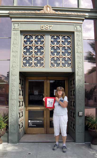
Address: I-5 and Lyons Ave, Newhall, CA

Description:

This plaque is sort of a double find for us and it seems to be fitting that it commemorates the first gold find in California in 1842. When we found the previous plaque on the first commercial liquid gold (oil) refinery in California, there right beside it, up from the Burger King, was the plaque telling about the first gold strike in California. There is not anything remaining of the gold strike and the plaques are located on a busy street. You have to be willing to step into traffic to read the plaques. But we did and lived.

After writing and researching this, I think that team Thing One, Thing Two found the lazy person's plaque for the Oak of the Golden Dream. After seeing some sites, we probably stopped at a California Landmark plaque for the Oak. But the real oak is 6 miles down the road. By the way, we are glad that we were mistaken. Somehow, it seemed wrong that such an oak would have been cut down to make a Burger King.


NO. 168 OAK OF THE GOLDEN DREAM - Francisco López made California's first authenticated gold discovery on March 9, 1842. While gathering wild onions near an oak tree in Placerita Canyon he found gold particles clinging to the roots of the bulbs. The San Fernando placers and nearby San Feliciano Canyon were worked by Sonoran miners using panning, sluicing and dry washing methods. Lopez's find predated James Marshall strike at Sutter's Mill by six years.
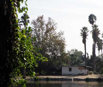
Location: Site: Placerita Canyon State and County Park, Placerita Canyon Rd, 4.6 mi NE of Newhall (Los Angeles)
Plaque: SE corner I-5 and Lyons Ave, Newhall


From Waymarking about the other plaque commemorating the gold find:
It is purported that Jose Francisco De Gracia Lopez fell asleep under an oak in Canon de los Encinos (Live Oak Canyon) and dreamt of gold. When he awoke, he was hungry and dug up some wild onions at the base of a nearby tree with his pocket knife. Clinging to the roots of the onions were nuggets of gold. Lopez and his associates scoured the nearby riverbanks and discovered more pockets of gold. They took their findings to nearby Los Angeles and relayed word of their discovery to their native Mexico City. The gold was assayed by the Philadelphia Mint and found to be .926 fine. Hundreds of prospectors from Los Angeles and Sonora, Mexico flocked to Live Oak Canyon, which was renamed Placerita Canyon. The word "placer" is of Spanish origin and means surface deposits of sand or gravel containing gold. From 1842 to 1847, the miners culled some 1,300 pounds of gold from Placerita. This is the first recorded authenticated find of gold in the area and that which is believed to have kicked off the monumental California Gold Rush in 1842. Additionally, Lopez’s was the first attempt at establishing a mining claim. Historians disagree on whether significant gold finds preceded that of Lopez, but his is surely the most legendary.

The oak tree beneath which Lopez took his fateful nap is now a California Historical Landmark, the Oak of the Golden Dream, and is located within the boundaries of the Placerita Canyon Park. It is the featured site of this earthcache and is a short, pleasant walk down the paved Heritage Trail.


References:


Overall Landmark References:

Adventure 051, Site 156 – Pioneer Oil Refinery

Capture California, the Game-2012
Adventure: 051, Site 156 – Pioneer Oil Refinery
California Landmark Number: 172


Team: Thing One, Thing Two
Date:  October 6, 2012
Location:
Latitude: 4° 22.696′ N
Longitude: 118° 33.83′ W
Address: State Plaque at Lyon Boulevard Exit of I-5

Description:

We got back onto I-5 with the idea of visiting other plaques in Newhall. So after a minute on I-5, we took the Lyon Boulevard exit and there is was, right before our eyes. This plaque is only a marker for the area where the first commercial oil refinery stood.


NO. 172 PIONEER OIL REFINERY - In 1875 the Star Oil Company, one of the predecessors of the Standard Oil Company of California, drilled its first Pico Canyon well, which yielded about one hundred barrels per day. The discovery resulted in the erection of the first commercial oil refinery in California the following year.
Location: Site and private plaque at 238 Pine St, Newhall - state plaque at Lang Blvd exit of I-5


According to HMDB: The site of the refinery does not have an actual marker that can be seen. The location is fenced off and access is not allowed but you can get a decent view looking through the fence. The site is located at 238 Pine Street, Newhall, California. This is the oldest still standing oil refinery in the Western Hemisphere (perhaps World)


References:


Overall Landmark References:

Adventure 051, Site 155 – Lyons Station Stagecoach Stop


Capture California, the Game-2012
Adventure: 051, Site 155 – Lyons Station Stagecoach Stop
California Landmark Number: 688


Team: Thing One, Thing Two
Date:  October 6, 2012
Location:
Latitude: N 34° 21.730
Longitude: W 118° 30.441
Address: 23287 North Sierra Highway, Newhall, CA

Description:

We credit the LA freeways for this find. We had gotten on I-5 from 210, we started to settle in. Then Thing One says, Ohh, Oh, I think we are on the wrong freeway—Highway 14 had taken off on us and we were approaching Newhall. Thing Two said that there was more landmarks in Newhall. One was right by us, the Lyon's Station. So off we went down the Sierra Highway and then we came up to a memorial park. This was it and right there at the entrance was the plaque. The building behind the plaque is a modern chapel. Thing Two spies an ancient hearse and has to take picture of this one as well—it was the last horse drawn hearse in Los Angeles county.


NO. 688 LYONS STATION STAGECOACH STOP - This site was the location of a combination store, post office, telegraph office, tavern, and stage depot accommodating travelers during the Kern River gold rush in the early 1850s. A regular stop for Butterfield and other early California stage lines, it was purchased by Sanford and Cyrus Lyons in 1855, and by 1868 at least twenty families lived here. Eternal Valley Memorial Park has called their final resting place "The Garden of the Pioneers."
Location: Eternal Valley Memorial Park, 23287 N Sierra Hwy, near State Hwy 14 and San Fernando Rd, Newhall


References:


Overall Landmark References:

Adventure 051, Site 154 – Old Mill


Capture California, the Game-2012
Adventure: 051, Site 154 – Old Mill
California Landmark Number: 302
National Registry ID: 1971000154


Team: Thing One, Thing Two
Date:  October 6, 2012
Location:
Latitude: N 34° 07.112
Longitude: W 118° 07.661
Address: 1120 Old Mill Rd, San Marino

Description:
Date Built: 1823
Architect: Father José María Zalvidea


In a very nice part of San Marino—everything which I have seen in San Marino is nice—we find the the landmark sign for the Old Mill. It is now the California Art Club. We walk up the driveway, as there is a sign saying limited parking and no turn around. The Old Mill is behind an adobe wall with a locked gate. The Art Museum does not open for another three hours. So we have to be content with the shade of some broadleaf trees and looking over the wall before retreating back to the car.

NO. 302 OLD MILL - The Old Mill, El Molino Viejo, was designed by Father José María Zalvidea and built of fired bricks and adobe about 1816 to serve Mission San Gabriel. Another grist mill was built in 1823 near the mission and the old mill was gradually abandoned - it passed from mission control in 1846. The property remained in private hands until 1903, when Henry E. Huntington bought the building and used it for a golf clubhouse. Later owners, Mr. and Mrs. James Brehm, had the mill restored in 1928 by Frederick Rupple.
Location: 1120 Old Mill Rd, San Marino


From the NRHP:
In designing the mill, Father Zalvidea pioneered the use a horizontals direct impulse waterwheel. Built by Mission Indians under the supervision of the Majordomo, the mill was finished about l8l6 in the Spanish tradition. Cement and lime were locally made. The thick lower walls and foundations are. of quarried volcanic stones arid are strengthened by corner buttresses. The upper walls,3' thick, and the arched water chambers are of fired, hand -made adobe brick. The tile roof is supported by a wood frame structure.


References:


Overall Landmark References:

Adventure 051, Site 153 – Governor Stoneman Adobe

Capture California, the Game-2012
Adventure: 051, Site 153 – Governor Stoneman Adobe
California Landmark Number: 669


Team: Thing One, Thing Two
Date:  October 6, 2012
Location:
Latitude: N 34° 06.875
Longitude: W 118° 08.193
Address: 1912 Montrobles Place , San Marino, CA

Description:


Thing One is not sure how he would feel about having a plaque in his front yard, along with a remnant of a adobe wall. But that is where we found this landmark, in a residential area. So it is a stop and take a picture and be off, rather than snooping into someone's front year.


Stoneman was both a general in the Union army during the Civil War. He later on served as Governor of California for a single term as a Democrat, from 1882-1886. If you remember the Robbie Robertson song, The Night They Drove Ole Dixie Down, Stoneman is mentioned in there:


Virgil Caine is the name, and I served on the Danville train,
Till Stoneman's cavalry came and tore up the tracks again ..


NO. 669 GOVERNOR STONEMAN ADOBE, LOS ROBLES - This was the site of 'Los Robles,' the 400-acre estate of Governor George Stoneman. President Rutherford B. Hayes was entertained here in 1880. The first schoolhouse in the San Gabriel Valley, California's first tennis club, and the first municipal Christmas tree of San Marino were located here.
Location: 1912 Montrobles Place, San Marino


From Waymarking:
This was the site of 'Los Robles,' the 400-acre estate of Governor George Stoneman. President Rutherford B. Hayes was entertained here in 1880. The first schoolhouse in the San Gabriel Valley, California's first tennis club, and the first municipal Christmas tree of San Marino were located here.


References:


Overall Landmark References:

Adventure 051, Site 152- Gamble House


Capture California, the Game-2012
Adventure: 051, Site 152- Gamble House
California Landmark Number: 871
National Registry ID: 1971000155


Team: Thing One, Thing Two
Date:  October 6, 2012
Location:
Latitude: 34° 9.102′ N
Longitude: 118° 9.648′ W
Address: 4 Westmoreland Place, Pasadena, CA

Description:
Date Built: 1908
Architect: Charles Sumner Greene and Henry Mather Greene

If we had only looked at some of the photo's before going to the house, we would have saved ourself a lot of time wandering. But then again, when has team Thing One, Thing Two ever been adversed to wandering? We went to the house looking for its plaque. After due examination, Thing Two started a walk around the house, while Thing One having seen some plaques down the street turned to investigate those. But both of those searches were in error. The plaque was right there by the house all of the time. This time, the plaque sunk in the grass by the sidewalk in front of the house.

The house itself is wood-sided and stands out. It is part of USC and is a show case of fine architecture. By the way, the David and Mary Gamble whose house this was? This is the same Gambles as in the company, Proctor and Gamble.


NO. 871 THE GAMBLE HOUSE - Built in 1908, the David B. Gamble House is a tribute to the genius of architects Charles Sumner Greene and Henry Mather Greene. Its design represents a unique California lifestyle and is a masterpiece of American craftsmanship. In 1966 it was made a gift by the Gamble family to the City of Pasadena in a joint agreement with the University of Southern California.
Location: 4 Westmoreland Place, Pasadena


References:


Overall Landmark References:

Adventure 051, Site 151 – First Trust Building


Capture California, the Game-2012
Adventure: 051, Site 151 – First Trust Building
National Registry ID: 1987000941
Team: Thing One, Thing Two
Date:  October 6, 2012
Location:
Latitude:34°8′46″N
Longitude: 118°8′13″W
Address: 587-611 East Colorado Boulevard and 30-44 North Madison Avenue, Pasadena, CA

Description:
Date Built: 1927
Architect: Cyril Bennett and Fitch Haskell
Architectural Style: Renaissance Revival, Mediterranean Revival, Late 19th And 20th Century Revivals
Date added to NRHP: June 12, 1987
When we were walking around Old Pasadena, we saw this building. It had a plaque, but a pretty modern day plaque and nothing which said it was historical. But the building itself called attention to itself. From the tall cupola with its steel and glass, down to the street-level exterior, it just called to us. The building is meant to call out to people. Later on we wandered past the same intersection and saw that it was on the National Registry of Historical Places-still no plaque, but at least the right address. Currently it houses the Bank of the West.


References:


Overall Landmark References:


Adventure 051, Site 149 – Pasadena Playouse


Capture California, the Game-2012
Adventure: 051, Site 149 – Pasadena Playouse
California Landmark Number: 887
National Registry ID: 1975000435


Team: Thing One, Thing Two
Date:  October 6, 2012
Location:
Latitude: N 34° 08.709
Longitude: W 118° 08.230
Address: 39 South El Molino Avenue, Pasadena, CA

Description:
Date Built: 1924
Architect: Elmer Grey


On this Saturday morning, Thing One and Thing Two strolled around Pasadena to see the sights. One of the destinations was the Pasadena Playhouse. The building itself blends in with the other buildings along the El Molino. Sort of a non-descript plaster building. When we got there, a couple actresses where waiting for the building to open. We climbed the short set of stairs and found our plaque and went off for more adventure.


The playhouse is considered Elmer Grey's outstanding design. Each year it produces an outstanding set of productions and has produced many of the worlds theater stars.


NO. 887 PASADENA PLAYHOUSE - Founded in 1917 by Gilmor Brown, the Pasadena Playhouse was designed by architect Elmer Grey and the cornerstone laid May 31, 1924. In 1928 the College of Theatre Arts was incorporated with the Pasadena Playhouse Association as a non-profit institution. In 1937, the Playhouse received the honorary title 'State Theatre of California' from the California Legislature.
Location: 39 El Molino Ave, Pasadena


References:


Overall Landmark References:

Adventure 051, Site 150 – Pacific Asia Museum


Capture California, the Game-2012
Adventure: 051, Site 150 – Pacific Asia Museum
California Landmark Number: 988


Team: Thing One, Thing Two
Date:  October 6, 2012
Location:
Latitude: 34° 8.805′ N
Longitude: 118° 8.461′ W
Address: 46 North Los Robles Ave, Pasadena CA

Description:
Date Built: 1929

In looking at some web pictures of the building, we did not get enough perspective on it. We were able to park pretty close to the building. The front of the building looked very much like any other building. There was a couple of plaster-cast statues in front, but nothing terribly exciting. Even the mural on the side of the building looked typical LA style. What we missed was to walk across the El Molino and observe the front from a distance, to see the upper-story decorations.


NO. 988 PACIFIC ASIA MUSEUM (GRACE NICHOLSON'S TREASURE HOUSE OF ORIENTAL AND WESTERN ART) - Grace Nicholson, a noted collector and authority on American Indian and Asian Art and artifacts, supervised the design of her combination gallery and museum which was completed in 1929. It has been called an outstanding example of 1920s revival architecture and is unique for its use of Chinese ornamentation.
Location: 46 North Los Robles Ave, Pasadena


References:


Overall Landmark References:

Adventure 051, Site 148 - Singer Building


Capture California, the Game-2012
Adventure: 051, Site 148 - Singer Building Pasadena
National Registry ID: 85001066[1]

Team: Thing One, Thing Two
Date:  October 6, 2012
Location:
Latitude: 34°8′44″N
Longitude: 18°8′20″W
Address: 16 S. Oakland Ave. and 520 E. Colorado Blvd., Pasadena, California

Description:
Date Built: 1926
Architectal style: Spanish Colonial Revival
Added to NRHP May 16, 1985

We came across this building when we were walking between two California Historical Buildings . It is always great to come across the unexpected and discover a bit more of California History.


From NRHP:
The Singer Building is architecturally significant as "a good, as yet unspoiled example of Spanish Colonial Revival commercial work. Its style, quality, scale, and location capture the essence of the historic character of Pasadena's symbolic and actual main street, Colorado Boulevard, during its heyday in the 1920s.


References:


Overall Landmark References:

Friday, October 5, 2012

Adventure 051, Site 147 – Baldwin Queen Anne House

Capture California, the Game-2012
Adventure: 051, Site 147 – Baldwin Queen Anne House
California Landmark Number: 367
National Registry ID: 1980000804


Team: Thing One, Thing Two
Date:  October 5, 2012
Location:
Latitude: N 34° 08.479
Longitude: W 118° 03.230
Address: Los Angeles State and County Arboretum, 301 N Baldwin, Arcadia

Description:
Date Built: 1881
Architect: A.A Bennett-the same architect which designed the State Capital and the Merced Courthouse, and father-in-law to EJ Baldwin


This house is just a matter of a hundred feet from the Reid Adobe. It has an appears of a fairy tale house amongst all of the greenery surrounding it. We walked around the house, well until we came to a taped off section due to bees. But the house was closed when we were there. This would be a good backdrop for a celebration. Think of having all of the Arboretium as a place to stroll.


After reading some of the information concerning the house, it is right. Even thought the house was made as a guesthouse, it reminded Thing One more of a gazebo or recreational house than a place for someone to live.


NO. 367 E. J. BALDWIN'S QUEEN ANNE COTTAGE - Designed by A. A. Bennett for entertaining, the cottage was constructed by Elias Jackson ('Lucky') Baldwin in 1881. Since there was no kitchen, meals were served from the nearby adobe (built by Hugo Reid in 1839) where Baldwin actually lived. The building was restored and dedicated May 18,1954 as part of Los Angeles State and County Arboretum.
Location: Los Angeles State and County Arboretum, 301 N Baldwin, Arcadia


From NRHP:
Though it is actually of Stick-Eastlake design, Elias Jackson ("Lucky") Baldwin's guesthouse (1885) is commonly referred to as the "Queen Anne Cottage". In reality, only the octagonal configuration of the tower hints at the Queen Anne, a style in which the use of polygonal towers and assorted large bays and gables often defined the volumes of the building. The idea of the tower itself in American architecture can be traced back to the Italian Villa mode of the 1840's in which a picturesque silhouette for buildings was important, and in which the idea of the Italian belvedere from which to view the countryside became popular.


The character of the building as a folly is emphasized by its relative isolation in an exotic landscape ensemble which includes a natural lake, specimen trees, cultivated lawns, and wild undergrowth. The lake remains much as Baldwin landscaped it in the late 1880 T s, though there has been a loss of a number of the decorative granite boulders which once rimmed the perimeter. … A grove of Mexican fan palms planted by Baldwin, now among the tallest in the continental United States, tower over the Cottage grounds; willows still grace the lake shore; a 160 foot tall blue gum Eucalyptus shelters the Cottage walkway; a magnificent English Oak planted by Baldwin in 1876 still shades the lawn between the Cottage and the Barn; and descendants of Baldwin planted black walnuts, gingkoes, cypress, elms, and persimmons lend variety to the landscape.


Elias Jackson ("Lucky") Baldwin, a San Francisco businessman who had made millions in Comstock dealings, used $200,000 of his fortune to purchase the 8,500 acre Rancho Santa Anita in 1875. A loan foreclosure on the Temple and Workman Bank (Temple and Workman lands were held as collateral) plus additional land purchases increased his Southern California holdings to nearly 50,000 acres within a year and made Lucky Baldwin a landowner of acknowledged importance in the Southland.


References:


Overall Landmark References:

Adventure 051, Site 146 – Reid Adobe

Capture California, the Game-2012
Adventure: 051, Site 146 – Reid Adobe
California Landmark Number: 368


Team: Thing One, Thing Two
Date:  October 5, 2012
Location:
Address: 301 North Baldwin in Los Angeles Arboretum

Description:
Date Built: 1839


The Reid Adobe is within the Los Angeles County Arboretum. We had just done our hike with our daughter up Santa Anita Canyon when the Arboretum was before us. We decided that it would be nice to wander through here and discover what was inside. Our youngest daughter lives in Los Angeles and had not been here. What we found was an oasis within the urban desert. By a pond, we saw the Reid Adobe., which probably is not the correct location, but it is a representation of the building.


The Reid Adobe was used as a living quarters by EJ Baldwin while he built his house. Then later on when Baldwin built his house, it was used to cook the meals. The Baldwin house did not have any cooking facilities.


NO. 368 HUGO REID ADOBE - Hugo Reid, a Scotsman, petitioned the government of Mexico to grant him Rancho Santa Anita. His claim strengthened by his marriage to Victoria, a native Indian of the San Gabriel Mission, he received the grant on April 16, 1841. Immediately upon filing his petition, Reid took possession of the land, started to farm and plant vineyards, and built the first house-the Hugo Reid Adobe-in 1839. In 1875, E. J. Baldwin purchased the rancho and in 1879 added a wooden wing to the old adobe.
Location: Los Angeles State and County Arboretum, 301 N Baldwin Ave, Arcadia


From the LA Arboretum Historical Site:
Don Perfecto Hugo Reid (1810-1852), a Scottish adventurer and naturalized Mexican citizen, was the first private owner of the 13,319 acre Rancho Santa Anita. The adobe was constructed in 1840 with the help of Gabrielino laborers. It was built of sun-dried adobe blocks made by mixing clay soil, water and a straw binder. The roof was made of rawhide-lashed carrizo cane (Arundo donax). As protection from the elements, the roof was smeared with brea (tar) and the walls were white-washed.


References:


Overall Landmark References: