Capture Calif

Capture California

What is a YOLT? Well, you may have heard the term YOLO. Gary and Sherri think we can live again, not as James Bond, but as being reborn. Consequently, we are having fun in our life, after all, You Only Live Twice.

Sunday, June 30, 2013

Adventure 005, Hike 026 – Island Pass to Trinity Lakes

After climbing a saddle

Capture California, the Game-2013
Adventure: 005, Hike 026 – Island Pass to Trinity Lakes

Team: YOLT
Date:  June 30, 2013
Location: Inyo National Forest

Hike Info:
Trail: John Muir Trail – Island Pass to Trinity Lakes
Distance: 11.5 miles
Duration: 5:51 Moving
Elevation Rise: 1,772'


Start of day with Gary
Description:
What a glorious sunrise—to make the majestic sunset of the previous night. But this hike today is a series of ups and downs . Each by themselves is not terrible, but put together, they tend to be grueling. But there is some pretty good country out there to match the hardness of the trail. Read more in our trail blog.


Adventure 011, Tagged Person 024-Terri F

Ranger Terri F and Gary
Capture California, the Game-2013
Adventure: 011, Tagged Person 024-Terri F

Team: YOLT
Date:  June 30, 2013
Location: Shadow Creek

Description:
We had stopped for lunch at Shadow Creek when we noticed a trail crew working close by. Gary went over and talked with them, wondering if they had worked the downed trees from the previous year—yes and no. The no, they had not, but their company had. A few minutes later, Terri F, the wilderness ranger for Inyo National Forest came over to make sure everything was ok. We started talking, after she checked our permit. She, like other wilderness rangers, was a good source of information and friendly to boot. Enjoyed talking with her. See Adventure 006, Ranger 03 .

Adventure 006, Ranger 03 - Inyo National Forest

Ranger Terri F and Gary
Capture California, the Game-2013
Adventure: 006, Ranger 03 - Inyo National Forest

Team: YOLT
Date:  June 30, 2013
Location: Shadow Creek, Inyo National Forest

Description:
We had stopped for lunch at Shadow Creek when we noticed a trail crew working close by. Gary went over and talked with them, wondering if they had worked the downed trees from the previous year—yes and no. The no, they had not, but their company had. A few minutes later, Terri F, the wilderness ranger for Inyo National Forest came over to make sure everything was ok. We started talking, after she checked our permit. She, like other wilderness rangers, was a good source of information and friendly to boot. Enjoyed talking with her.

As a note, a couple of weeks later, when we came down from Whitney, we met her supervisor, Margaret.


Saturday, June 29, 2013

Adventure 011, Tagged Person 034, Nicole R

Gary and Nicole R on top of Donohue Pass
Capture California, the Game-2013
Adventure: 011, Tagged Person 034, Nicole R

Team: YOLT
Date:  June 29, 2013
Location: Donohue Pass

Description:
We met Nicole a little before Donohue Pass, where we all were crossing on outlet to a glacial pond. Then caught up to her at Donohue Pass, where this picture was taken. During the next week, we would meet up with her off and on until she finally passed us for good at Goddard Creek See Adventure 005, Hike 024 .


Adventure 005, Hike 024 – Lake 10,185' to Island Pass

Gary and Nicole R on top of Donohue Pass
Capture California, the Game-2013
Adventure: 005, Hike 024 – Lake 10,185' to Island Pass

Team: YOLT
Date:  June 29, 2013
Location: Yosemite NP and Inyo National Forest

Hike Info:
Trail: John Muir Trail - Lake 10,185' to Island Pass
Distance: 6.7 miles
Duration: 4:37 Moving
Elevation Rise: 1,440'


Description:
This day, we left Yosemite National Park by passing through Donohue Pass. Then descending through the Rush Creek basin and then climbing up to Island Pass. A very good day, especially since we climbed the first of the major JMT passes and met a new friend along the day. Read more in our blog.

Friday, June 28, 2013

Adventure 005, Hike 023 – Tuolumne Meadows to Lake 10,185'

High Above Lyell Canyon

Capture California, the Game-2013
Adventure: 005, Hike 023 – Tuolumne Meadows to Lake 10,185'

Team: YOLT
Date:  June 28, 2013
Location: Yosemite National Park

Hike Info:
Trail: John Muir Trail-Tuolumne Meadows to Lake 10,185'
Distance: 10.6 miles
Duration: 5:07 Moving
Elevation Rise: 1,506'


Description:
After a nice refreshing sleep in Lee Vining, it is time to hike again. We set off up Lyell Canyon and make good time. When we hit the end, we start our Donohue Pass climb. We stop at lake 10,185' for the night. See our blog for more info.
Start of Day


Thursday, June 27, 2013

Adventure 005, Hike 022-JMT, Day Three

Capt

ure California, the Game-2013
Adventure: 005, Hike 022-JMT, Day Three
Team: YOLT
Date:  June 27, 2013
Location: Tuolumne Meadows, Yosemite
Hike Info:
Trail: JMT-From Long Meadows to Tuolumne Meadows
Distance: 9.25 miles
Duration: 5:02 Moving
Elevation Rise: 1,168'

Description:
The third day of our trip. We are looking forward to this since our son is coming in, bring us our new food supply for the next seven days, and we will be sleeping in a hotel room in Lee Vining tonight. Also, the trail has a short up to reach Cathederal Pass, then it is all downhill or flat until we reach the wilderness ranger's office at the far end of Tuolumne Meadows. To find out more about our day, read our blog.


Adventure 003, Site 017-Parsons Memorial Lodge


Sherri and Parsons Lodge marker
Capture California, the Game-2013
Adventure: 003, Site 017-Parsons Memorial Lodge

National Registry ID: 79000283


Team: YOLT
Date:  June 27, 2013
Location:
Address: Tuolumne Meadows

Description:
Date Built: 1915
Architect: Mark White and Walter Huber, Bernard Maybeck (probably)

Parsons Lodge
We walked across Tuolumne Meadows with our initial John Muir Trail packs. For some reason our stride was good and the step was quick. So we made good time on this flat ground. Coming to Parsons Lodge, we did three things: took off our packs, drink some water-it was warm, and talked to the volunteer manning the Lodge. We have been to the Lodge several times, so talking with the volunteer was good. The stones from the building do give a sense of being part of the area, rather than a building incongruous with its surrounding.

==========
The lodge is a memorial to Edward Taylor Parsons, a New Yorker who joined the Sierra Club about 1900, and who eventually became the club's director from 1905 to 1915. Parsons was heavily involved in the losing fight against the flooding of the Hetch Hetchy Valley to provide a municipal water source for San Francisco. Parsons died in 1914, and in memorial the Sierra Club established a fund to build a club meeting house, library and headquarters in Yosemite. The site at Tuolumne Meadows was chosen for its accessibility to park backcountry and its location near Soda Springs, a location that the Sierra Club wished to safeguard.[4]
It is not clear who designed the Lodge. Mark White, brother-in-law and partner in Maybeck and White to architect Bernard Maybeck, was credited at the time of the lodge's completion. White was a Sierra Club member. Maybeck scholars Gary Brechlin and Kenneth Cardwell have suggested that Maybeck was involved in the design, chiefly through similarities to Maybeck-designed buildings at Lake Tahoe. Maybeck is alleged to have done the conceptual design, which was developed by White and White's brother John, who would go in to design the LeConte Memorial Lodge. (Wikipedia)


References:


Overall Landmark References:

Adventure 003, Site 015-Tioga Pass Entrance Station

Gary and the Highway Marker

Tioga Pass Entrance Station, and Gary and Flag
Capture California, the Game-2013
Adventure: 003, Site 015-Tioga Pass Entrance Station

National Registry ID: 78000372


Team: YOLT
Date:  June 27, 2013
Location:
Address: Tuolumne Meadows/Tioga Pass

Description:
Date Built: 1931


Sherri and Gary decided that when our son Steven came along to restock us at Tuolumne Meadows, we would head on down to Lee Vining and take a room for the night before returning to the Trail. Along the way, we exited from Yosemite via Tioga Pass. We knew there was an old guard station there, and sure enough, it was on the NRHP.


So what makes a park entrance station and its restroom and the two pillars—which have been removed—historic? First, it was a product of the Civilian Conservation Corps. It is a good example of their work in the high Sierra's. It is a product, and in some ways a fore running of the Yosemite rustic look. Buildings made from local materials, designed to blend in and be harmonious to its surroundings. It was the first in the area, and set the tone for other buildings such as the Tuolumne Meadows ranger and comfort station.


Tioga Pass Entrance Station
This is a building which the people of the United States got its $3,900 worth in 1931. The guard station could sleep 1 to 4 people. The comfort station located to the south of the guard station was built three years later for $2,737. The original pillars supported a gate and were removed in 1999. Later in 1940 an entrance kiosk was built. The NRHP application termed is as “non-harmonios”. We cannot say that the replacement kiosk is much better, though one would suspect it is a bit more comfortable. Except fot the paving of the road, removal of the pillars and gates and updating of the kiosk, not much has changed to this eastern entrance to Yosemite since 1940.
An older picture of the entrance


References:


Overall Landmark References:

Adventure 003, Site 003, Site 014-Soda Springs Cabin


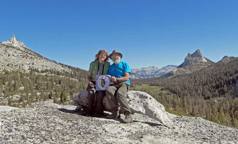
Gary and the Cabin at Soda Springs
Capture California, the Game-2013
Adventure: 003, Site 003, Site 014-Soda Springs Cabin
National Registry ID: 79000282


Team: YOLT
Date:  June 27, 2013
Location:
Address: Tuolumne Meadows, Yosemite
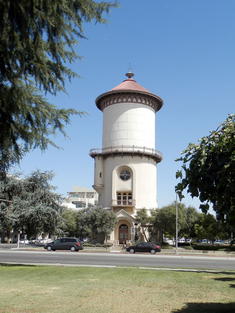
The Soda Springs

Description:
Date Built: 1885
Architect: Lembert, John Baptiste

As we were hiking the John Muir Trail, we came to Tuolumne Meadows, a place of refreshment and history. One of the places of history is Soda Springs. Water bubbling to the surface. This particular spring has been enclosed in a log cabin structure—does not look old. There are several other springs in the area. The cabin is close to Parson's Lodge, just across the hill from the Lodge.

John Baptist Lembert found this place in 1885, then built his cabin in 1889. The cabin is all which survives of Lembert's homestead. He used the meadows to graze his flock of angora goats. Later when the Great Western Wagon Road—the prelude to the current Tioga Pass Road—was built, Lembert became a noted guide to the area, having acquired the titles of entomolist and naturalist. This sort of happens as you get to know the area. In his youth, he was educated in Latin, so the biological names were not an issue for him.

The cabin, which the ruins are around the springs, was built to keep animals out of the springs, keeping the water fresh and pure. The current cabin is a replica of the old cabin, without a roof. Around 1896 or 1897, Lembert was murdered in Yosemite Valley, as part of a robbery. Lembert Dome, on the east side of Tuolumne Meadows, was named in his honor. Also, because of his role in collecting several plant species for the Smithosian and Dept of Agriculture, he has a moth named after him: Hepialis lemberti.


PLACE:
Erroneously spelled LAMBERT on many maps and references.
John Baptist Lembert took up a homestead quarter-section of land in Tuolumne Meadows in 1885. The property included the soda springs and the meadow land across the river. He had previously lived in and around Yosemite. He built a log cabin on his claim and lived there, raising angora goats until the winter of 1889—go when he lost his goats in the storms. Thereafter he collected butterflies and botanical specimens, which he sold to museums. In 1895 he was issued a United States patent on his claim.
He continued to live on his soda-springs property during the summers, but spent the winters in a cabin near Cascade Creek below Yosemite Valley. Here, in the winter of 1896-97, his body was found, evidently murdered.
The Tuolumne Meadows property passed to his brother, Jacob Lembert who sold it in 1898 to the McCauley brothers. In 1912 it was purchased by members of the Sierra Club and held in trust for the club.
The Dome, being the most prominent object in the neighborhood, came to be known by the name of the hermit settler. (William E. Colby.—See, also, S.C.B., 1913, IX:1, pp. 36-39.)


References:


Overall Landmark References:

AdvRanger Cliff ARenture 011, Tagged Person 023-Cliff A

Ranger Cliff A
Capture California, the Game-2013
Adventure: 011, Tagged Person 023-Cliff A
Team: YOLT
Date:  June 27, 2013
Location: Yosemite
Description:
We met Cliff when he was out on wilderness patrol. Enjoyed talking with him. See Adventure006, Ranger 02 .


Adventure 006, Ranger 02, Yosemite Wilderness Ranger

Yosemite Ranger Cliff A
Capture California, the Game-2013
Adventure: 006, Ranger 02, Yosemite Wilderness Ranger
Team: YOLT
Date:  June 27, 2013
Location: Cathedral Lake Trail Jct, Yosemite
Description:
On the third day of our John Muir Trail trek, we came across Cliff, one of Yosemite's Wilderness Rangers, close to the Lower Cathedral Lake junction. Being on horseback—always a great impression. But even more impressive was the friendliness of Cliff. We talked some about the conditions ahead and the need to carry a bear canister—he did look over our pack to make sure we had one.


Then later on as we were getting close to Tuolumne Meadows, we met him coming back from patrol. He suggested a couple places to eat in Lee Vining before we left. We were left with the impression of a person who was really enjoying his work and was wanting others to enjoy their own adventures.


Later on this was confirmed when we overheard one of his fellow rangers talking about him. That has been my experience with the backcountry rangers. That 99 out of 100 of them, when we have talked with them, are having great days and enjoy being where they are.


By the way, on our trek, we saw two other NPS backcountry ranges: Leslie J in Kings Canyon and Greg P in Sequoia, both enjoying their work.

Wednesday, June 26, 2013

Adventure 005, Hike 021 – JMT Day Two

 Capture California, the Game-2013
Adventure: 005, Hike 021 – JMT Day Two
Team: YOLT
Date: June 26, 2013
Location: Yosemite
Hike Info:
Trail: John Muir Trail, Day Two from Sunrise Creek to Long Meadow
Distance: 7.33miles
Duration: 5:26 Moving
Elevation Rise: 2,250'


Description:
Our second day on the Trail. It is the middle day of this segment, between Glacier Point and Tuolumne Meadows—we have speculated we can make Tuolumne Meadows today, but are thinking we want to do a reasonable effort, because we will have a lot of days to travel before completing this journey. You can read about this segment on our blog.

Tuesday, June 25, 2013

Adventure 005-Hike 020 JMT Day 01

Capture California, the Game-2013
Adventure: 005, Hike 020 – JMT Day One
Team: YOLT
Date: June 25, 2013
Location: Yosemite
Hike Info:
Trail: John Muir Trail, Day One from Glacier Point to Sunrise Creek
Distance: 10.57miles
Duration: 6:20 Moving
Elevation Rise: 2,969'


Description:
This day we start our 25 day, 220 mile trip from Yosemite to Whitney Portal along the John Muir Trail. Today's segment is from Glacier Point to Sunrise Creek. While there is some divergence from the JMT along this segment—the JMT starts at Happy Isle instead of Glacier Point, it still maintains the spirit and flavor of the trail. We have done the trail from Happy Isle to Nevada Falls many times and wanted something different. You can read about this segment on our blog.

Adventure 011, Tagged Person 022, Instigator, ReHab, NoDae

Gary, Instigator, Re-Hab, No Dae
Capture California, the Game-2013
Adventure: 011, Tagged Person 022, Instigator, ReHab, NoDae
Team: YOLT
Date:  June 25, 2013
Location: Yosemite
Description:
We met Instigator, Re-Hab and No Dae while doing the JMT. They were part of our interview for the PCT. See Adventure 067 .


Adventure 067 – Interview a PCTer

Gary, Instigator, Re-Hab, No Dae
Capture California, the Game-2013
Adventure: 067 – Interview a PCTer
Team: YOLT
Date:  June 25, 2013
Location: Yosemite

Description:


We came across three PCTers on a side trip, going down to Yosemite Valley, as we were coming close to Sunrise Creek. The three are Instigator, Re-Hab and No Dae. They started out at the Mexico border in April and are aiming to get to Canada by the end of September. At this point, they had walked a little over 900 miles in two months. Asked if Instigator was a trouble maker—yes, she has a tendency to play tricks on both sides. Trail names are given to people; they do not get to make their own name.
An astute person might say, what are they doing going to Yosemite Valley when that is not on the PCT? True enough. They are not from California and wanted to see it and take a few days off of the Trail. For a PCTer, hiking the 27 miles to Yosemite is not too much more than a day's trip for them.
But these folks are not the only PCTers whom we have met during the past month. There are people like:
  • Team Turtle-a couple of trail angels who supply fruit and water in the desert. Fritz also is doing the PCT in sections.
  • Father daughter. We met the father around Sunrise meadow. He was taking a rather circular way over to see his daughter who is hiking the PCT. A couple of days later in Lyell Canyon we met both the father and the daughter (Night Crawler) as they were going north.
  • Free Range. She hiked the PCT a couple of years ago and now lives in northern California. She decided that she needed to do a short hike and was doing the JMT in about 10-14 days. We came across her at Edison Lake.
    An unnamed PCTer whom we talked with during a thunderstorm close to Silver Pass. He was doing the PCT, but had decided to take it easy and enjoy wherever he was rather than try to make miles.


Friday, June 21, 2013

Adventure 106-Summer Solstice

Capture California, the Game-2013
Adventure: 106-Summer Solstice
Team: YOLT
Date:  June 21, 2013
Location: Fresno
Description:
Part of the fun of living in Fresno is the ability to enjoy the sun each and every day of the summer. Of course in Fresno, sometimes we get too much of a good thing. But not on this fine first day of summer. It was a moderate 92, just the right temperature to enjoy the pool all day long.

Tuesday, June 18, 2013

Adventure 009, Bridge 008 – Lane's Bridge

Sherri the Bridgewalker
 Capture California, the Game-2013
Adventure: 009, Bridge 008 – Lane's Bridge
Team: YOLT
Date:  June 18, 2013
Location: Fresno, 36°52'34" N, 119°47'31" W
Description:
We learned something new tonight. Two years ago when we walked this bridge, all which we could call the bridge was old Highway 41 bridge over the San Joaquin River, that is pretty good in itself. This evening we found a plaque naming it Lane's Bridge.  But about 20 years ago, the two lane highway was replaced with a six lane highway and moved. But this old road is still there and is used to bring people into a mobile park.
The 750' length bridge was walked. The largest span is 60', with 14 spans making up the roadway. It was originally constructed in 1941. It can still hold 71 tons of traffic. Why is this called Lane's Bridge? Will, not sure, but according to Paula Lloyd of the Fresno Bee,
View of the San Joaquin from the bridge
In that answer was an account of the collapse of the original 1889 bridge. Below is the last part of the detailed accounting.
“The collapse pulled the bridge loose from its moorings on the west end,” Lloyd wrote.
(“West end” of the bridge no doubt provides another clue).
In any event, “A replacement bridge was built for $235,000. It’s not clear whether that replacement bridge still exists,” Lloyd related.
But that is not all, at the turn of the century, there was a small town at this location. What was it called? Bridges, CA-it even had a post office. Why was it called that? Because of the Lanes Bridge cross. A drawing of the original bridge can be found online.

Adventure 221, Event 01 – Things Starting with “W”


Capture California, the Game-2013
Adventure: 221, Event 01 – Things Starting with “W”
Team: YOLT
Date:  June 18, 2013
Location: Woodward Park
Description:
#TwitterTuesday Do an OUTDOOR activity that starts with the letter "W". Examples: wakeboard, whiffle ball, water fight... Get creative!


While those “w” things sound ok, Sherri and Gary thought we would do a fun thing our on Way. So our Twitter Tuesday event, the first of this season—we are not on Twitter, consisted of a Walk With a Woman, Who is my Wife With Wine at WoodWard Park.

Sunday, June 16, 2013

Adventure 255-Father's Day

Gary and Steven on Father's Day
Capture California, the Game-2013
Adventure: 255-Father's Day
Team: YOLT
Date:  June 16, 2013
Location: Woodward Park, Fresno
Description:
Today-Father's Day--my son, Steven, and my wife, Sherri, took me on a hike out at Woodward Park. For a good description of what the hike was like, see our blog at our Capture California site.

Adventure 005, Hike 019 - Tom MacMicheal Trail

Gary and Steven on Father's Day outing


Capture California, the Game-2013
Adventure: 005, Hike 019 - Tom MacMicheal Trail
Team: YOLT
Date:  June 16, 2013
Location: Woodward Park, Fresno
Hike Info:
Distance: 2.90 miles
Duration: 0:55 Moving
Elevation Rise: 178'


Description:
We are doing this hike after church and before our Father's Day lunch/dinner. So we get started around 11:30. Even so, it is in the mid-80's when we start in. Last year, we pointed out that during the summer, mornings or evenings are the only sane time to do this trail-not mid-day like this. Fortunately, there is much reward in doing this trail. While short, you get to walk through the flood plain of the San Joaquin River, as well as seeing a great view of the area from its bluffs.
One of the improvements from last year is the new signs explaining both the area and the human history of it. It told about the development of the land and the conflicts between the farmers and the cattle ranchers. A farmer by the name of Moses Church brought in irrigation and farmed the area we were walking. The cattle ranchers were not able to graze their cattle. Church had a couple of unsuccessful assassination attempts on him. Sort of reminded me of the play Oklahoma where the Farmer and the Cowman should be friends, ….
Wading in the San Joaquin River
The trail starts in the Northwest portion of Woodward Park. In 1968, Ralph Woodward bequeathed the land for a regional park and bird sanctuary. Since that time, it has grown into its role as a means for people to be outdoors—from a large amphitheater where Shakespeare plays are produced for free to a place to watch birds to BMX courses. It is along the BMX course where the first part of the trail follows. It is nicely separated, allowing for good watching to the bikes. Before descending into the San Joaquin River flood plain, you get this good view of the plain and where we will be walking.
The trail starts the upper part of its lollipop loop. It heads towards the river, which is very accessible. Majestic oaks grow beside it. All along the trail wildlife emerge at dusk. From rabbits to mice to ground hogs to swallows to great egrets. This is a wonderful time to walk this trail.

Red-Tail Hawk
Even more so than last year, a new area of the San Joaquin River bottom has opened up, given us another mile or so to hike. This area is still being returned back to its natural status. But you do get to enjoy a bit more of animals of the area. We see a either a great or cattle egret, a red-tailed hawk , numerous other birds. Plus there are the ground squirrels scurrying around, some pocket gophers, along with a dead harvest mouse. Signs indicate that a mother coyote is tending her young, so do not go trampling too near some of the places. It is amazing what you see with your eyes open.

See Falcon's book, Best Easy Day hikes: Fresno by Tracy Salcedo-Chourre, on page 10

Friday, June 14, 2013

Adventure 003, Site 012 – Twining Labs


Sherri and the Building
Capture California, the Game-2013
Adventure: 003, Site 012 – Twining Labs
National Registry ID: 91000308
Local Registry ID: 58

Team: YOLT
Date:  June 14, 2013
Location:
Address: 2527 Fresno Street, Fresno, CA

Description:
Date Built: 1930
Architect: Charles E. Butner

Twining Building
Twining Labs is a Fresno institution, going back to its founding in 1898. Fredrick Twining was a chemist, who began as a bacteriologist. He had a nation-wide reputation for the preparation of vaccines against cattle disease. His firm had the reputation of “We Will Test Anything”, and that they did-testing foods, drugs, sobriety, and even brandy quality. As the firm grew, there was more and more need of facilities, consequently the present building was built in 1930.

As designed by architect Charles E. Butner, the Twining Laboratories represents a fine example of Depression-era construction in a modestly-scaled and detailed Mediterranean idiom. Although this genre was quite popular in the design of schools and residences in the Fresno area during the 1910s and 1920s, it was not widely adopted for commercial buildings. Much of that original but small resource has been lost to urban renewal, making the Twining Laboratories a rare example of a stylistic type commonly seen in other California communities. (GHF)


Because stylistic modifications to the principal architectural facade have been minor, loss of original building fabric has been limited, and the primary function of the building has not changed appreciably for six decades, the property exhibits a substantial degree of historical and architectural integrity. (NRHP)


References:


Overall Landmark References:

Adventure 003, Site 013 – Physicians Building

Sherri and Physicians Building

Capture California, the Game-2013
Adventure: 003, Site 013 – Physicians Building
National Registry ID: 1978000664
Local Registry ID: 4

Team: YOLT
Date:  June 14, 2013
Location:
Latitude: 36°44′26″N
Longitude: 119°47′06″W
Address: 2607 Fresno, Fresno, CA

Description:
Date Built: 1926
Architect: Charles E. Butner

After such an impressive history, it is a reminder to us all that the current greatness of a place will diminish, be unappreciated and not be remembered by succeeding generations. There was no plaque on this site.
The Physcians Building

This building, which fuses elements of the Italian and Spanish Revival architectural styles, was designed by Charles E. Butner for six Fresno physicians and surgeons. It was the first building in the central San Joaquin Valley expressly designed for medical offices and laboratories. The practitioners in the Physicians Building were involved in a variety of professional specialties, including general surgery, pediatrics, obstetrics, and internal medicine. As a group and individually, the physicians in this building made numerous distinguished contributions to the growing city of Fresno. Among these achievements were Clinton Collins' service as County Physician from 1915 to 1920, Angus B. Cowan's position as both County Coroner and the leader of a community effort that secured accreditation for the county hospital by the American Medical Association and the American College of Surgeons in 1921, and Chester Vanderburgh's appointment as chief of the surgical staff at Fresno General Hospital.

At the time of its design and construction in 1926, the Physicians Building consisted of some twenty-eight rooms, grouped into separate office units that opened out onto an interior court. An octagonal fountain and fish pond, some eight feet across and built of beige-colored stone, provided a bench surface as well as atmospheric character for the central axis of the medical building. Rising some eighteen feet above a floor surface of highly-polished serpentine-green linoleum tile, a superbly detailed skylight allowed natural light to filter into this large court space through individually-set panes of pebbled glass installed below a clerestory roof. The woodwork that made up the ceiling's structural element, built of some thirteen inches of milled and layered double curves, was painted off-white. Eight quarter columns with simple striped and banded crests at capital height, as well as four corner columns, completed the formal symmetry of this elegant medical reception area.

Much of the interior has been lost in the 1960's when the fountain was removed and the ceiling covered over with acoustic tile. Still from the exterior, it is a building which beauty.


References:


Overall Landmark References:

Adventure 003, Site 011 – Fresno Water Tower

Sherri and Water Tower plaque

Capture California, the Game-2013
Adventure: 003, Site 011 – Fresno Water Tower

National Registry ID: 1971000139
Local Registry ID: 1

Team: YOLT
Date:  June 14, 2013
Location:
Latitude: 36°44′21″N
Longitude: 119°47′11″W
Address: 2444 Fresno St, Fresno, CA

Description:
Date Built: 1894
Architect: George Washington Maher
Fresno Water Tower


This is the premier landmark of Fresno. It has played prominently in the travel advertising for Fresno, as well as a TV Mini-series called Fresno, staring Carol Burnett and Tim Conway.

George Washington Maher, a Chicago architect, was commissioned to design Fresno's water tower in 1891. Completed in 1894, it was in constant use until 1963, when the pumping machinery was no longer adequate. The original design called for a library on the second and third floors, but it was never installed. For several years the first floor was used as a parking meter repair facility. In 2001 the second floor was removed and the interior of the tower remodeled to become the visitors' center for the City and County of Fresno. As part of this remodeling a landscaped plaza and separate restroom building were built adjacent to the tower. The water tower today remains Fresno's most distinctive and enduring architectural symbol.
In 1989, the Fresno Water Tower was dedicated to George M Bowman. This was, in the words of the plaque on the tower:
This water tower is dedicated to George M. Bowman in recognition for thirty-six years of dedicated service to the city of Fresno and for his accomplishments as a naval officer. He was the city's first chief engineer and became general manager of the Water Department. He designed innovative electrical systems for street lighting, several well known public buildings and Chandler Air Field. Attaining the rank of Rear Admiral in the Navy, his career was distinguished by courage, leadership and diplomacy. It earned him the Silver Star, one of the nation's highest medals for heroism awarded by the President of the United States. In conspicuous gallantry aboard the U.S.S. Saratoga carrier he restored power to the ship, saving the crew and vessel. The Chinese government decorated him with the Cravate Blue of the Order for Meritorious Participation in the Sino-American Cooperative Organization. For his outstanding contributions to the Armed Forces, the Veterans and Reservists, he received the Governor Earl Warren Trophy. We remember a man of valor who worked toward progress, world peace, understanding and the well-being of others.


References:

Overall Landmark References:

Adventure 003, Site 010 – Fresno Veteran's Memorial

Sherri at the Fresno Memorial Auditorium
Capture California, the Game-2013
Adventure: 003, Site 010 – Fresno Veteran's Memorial

National Registry ID: 1994000427
Local Registry ID: 52

Team: YOLT
Date:  June 14, 2013
Location:
Latitude: 36°44′23″N
Longitude: 119°47′15″W
Address: 2425 Fresno St, Fresno, CA

Description:
Date Built: 1936

Fresno Veteran's Memorial
When built, the Fresno Memorial Auditorium was the center of cultural activity in Fresno. Since the building of the SaroyanTheater and the Convention Center in the 1960's, the Fresno Memorial Auditorium's use has diminished. But even now it serves a variety of purposes, such as local groups put on theater productions, certain City administrative functions are situated here as well. Even more moving is the entry in the auditorium. Two rows of flags flank the entry way. At the base of each flag are memorial plaques with the names and records of those who have served this country and have lost their lives.

In the 90's, a veteran's group established the National Legion of Valor Museum in the building. The building was then renamed to being the Veterans Memorial Auditorium. There still is civic pride in the memorial. For example, recently an Eagle Scout candidate coordinated an effort to refurbish sections of the interior. He even obtained two acorns from Arlington to plant on the grounds.
Plaques around one of the many flag poles


References:
Overall Landmark References: