Capture Calif

Capture California

What is a YOLT? Well, you may have heard the term YOLO. Gary and Sherri think we can live again, not as James Bond, but as being reborn. Consequently, we are having fun in our life, after all, You Only Live Twice.

Saturday, August 31, 2013

Adventure 008, Doggie 01, In our pool

Gary and Ritto
Capture California, the Game-2013
Adventure: 008, Doggie 01, In our pool

Team: YOLT
Date:  August 31, 2013
Location: Fresno


Description:
Our dog Ritto, as in buritto, loves to swim. Gary just got a new mask with prescription lenses so he can see in the pool. Time to have fun!


Wednesday, August 28, 2013

Adventure 005, Hike 054-Weaver Lake

Sherri at the start of Weaver Lake Trail
Capture California, the Game-2013
Adventure: 005, Hike 054-Weaver Lake

Team: YOLT
Date:  August 28, 2013
Location: Sequoia National Forest

Hike Info:
Trail: Big Meadow to Weaver Lake
Distance: 6.58 miles
Duration: 3:38 Moving
Elevation Rise: 1,608'


Description:
Its Wednesday, so it is time to hike with our meetup group. The hike started off with some excitement with talking with the Tulare SAR. But then settled down into a pleasant hike up to Weaver Lake. To read more, see our blog.

Tuesday, August 27, 2013

Adventure 003, Site 034-Old Mountain View

Capture California, the Game-2013
Adventure: 003, Site 034-Old Mountain View
Mountain View Pioneer and Historical Association Sign


Team: YOLT
Date:  August 27, 2013
Location:
Coordinates: N 37° 22.816 W 122° 04.341
Address: 150 East El Camino Real, Mountain View


Description:
Date Built: 1852


Gary confesses. He was born and raised in Mountain View. He had seen this sign standing for quite sometime, but never did the research behind it. He certainly did not know who the Weilheimer brothers were. But in looking up this sign, he found out that they stood up to Levi Straus; they ran a successful store; owned property up in foothills; provided people with strawberries; and even mined for gold. Not bad for a couple of Jewish emigrants from Germany. Sort of seems appropriate that the site of their stable is now a BMW dealership. On the other hand, it seems that from these beginnings, ground zero for our current set of technologies is located in the same city.


Inscription: Site of Old Mountain View 1852 hotel and stage stop stores and blacksmith shop. Later Post office, school and St Joseph's Church.


References:


Overall Landmark References:

Adventure 031 – A Dam Picture

Reservoir side of BF Sisk Dam

Capture California, the Game-2013
Adventure: 031 – A Dam Picture

Team: YOLT
Date:  August 27, 2013
Location: B F Sisk Dam (37.059167, -121.074722 )


Front side of BF Sisk Dam
Description:
This dam is large, or should I say immense? It is the BF Sisk Dam, just west of Los Banos. The dam's height is 305 feet and it is 18,600 feet long. For those of you who love big number, think over 2 million acre-feet of water can be stored. This 50 year old dam is the largest off-stream dam in the world—off-stream means that there is no stream running into the reservoir. Some people know this dam as the San Luis Dam and Reservoir—it is the large dam you see when you come over Pacheco Pass.


References:


Adventure 003, Site 033 – Pacheco Pass


Capture California, the Game-2013
Adventure: 003, Site 033 – Pacheco Pass
California Landmark Number: 829


Team: YOLT
Date:  August 27, 2013
Location:
Coordinates: 37°3′59″N 121°13′7″W (Location of pass)
37° 4.825′ N, 121° 5.892′ (Location of plaque)
Address: Romero Overlook, San Luis Reservoir, 31770 W Hwy 152 (P.M. 8.0), 15 mi W of Los Banos


Description:


Looking Towards Pacheco Pass
We cannot say that driving into the Romero Center at San Luis Dam is inspiring or even refreshing-it is hot after coming in from the Bay Area. But it does give you a pause to consider what did Morega see when he came this way? What inspired him to establish Los Banos? I suspect that it may have been the fields of golden poppies, stretching from the Coastal Range to the Sierras; the Sierra's looming over this Valley. But today, we can only pause to ponder.


====
NO. 829 PACHECO PASS - On June 21, 1805, on his first exploratory journey into the San Joaquin Valley, Lieutenant Gabriel Moraga traversed and recorded this pass. Since then it has been trail, toll road, stagecoach road, and freeway-the principal route between the coastal areas to the west and the great valley and mountains to the east.Location: Romero Overlook, San Luis Reservoir, 31770 W Hwy 152 (P.M. 8.0), 15 mi W of Los Banos From CHL


Looking eastward from the summit of the Pacheco Pass one shining morning, a landscape was displayed that after all my wanderings still appears as the most beautiful I have ever beheld. At my feet lay the Great Central Valley of California, level and flowery, like a lake of pure sunshine, forty or fifty miles wide, five hundred miles long, one rich furred garden of yellow Composito. And from the eastern boundary of this vast golden flower-bed rose the mighty Sierra, miles in height, and so gloriously colored and so radiant, it seemed not clothed with light, but wholly composed of it, like the wall of some celestial city. Along the top and extending a good way down, was a rich pearl-gray belt of snow; below it a belt of blue and lark purple, marking the extension of the forests; and stretching long the base of the range a broad belt of rose-purple; all these colors, from the blue sky to the yellow valley smoothly blending as they do in a rainbow, making a wall of light ineffably fine. Then it seemed to me that the Sierra should be called, not the Nevada or Snowy Range, but the Range of Light. And after ten years of wandering and wondering in the heart of it, rejoicing in its glorious floods of light, the white beams of the morning streaming through the passes, the noonday radiance on the crystal rocks, the flush of the alpenglow, and the irised spray of countless waterfalls, it still seems above all others the Range of Light. From John Muir, The Yosemite, 1912


A trail nearby, through what is now Pacheco State Park, was used by the Yokuts people to cross the mountains and trade with other native people on the coast.[5] Spanish army officer Gabriel Moraga first recorded the pass in 1805.[1] Since then, it has been a major route between the Santa Clara Valley and the Central Valley. It was the site of one of the stage stations on the route of the Butterfield Overland Mail stagecoach route which connected the Saint Louis, Missouri with San Francisco from 1858 until 1861.[6] Other stage lines used the route thereafter until completion of the railroads within the state. From Wikipedia


References:


Overall Landmark References:


Adventure 003, Site 032 – Hayes Mansion


Capture California, the Game-2013
Adventure: 003, Site 032 – Hayes Mansion
California Landmark Number: 888
National Registry ID: 75000481


Team: YOLT
Date:  August 27, 2013
Location:
Coordinates: 37°15′44″N 121°49′15″W
Address: 200 Edenvale Ave, San Jose


Description:
Date Built: 1904
Architect: George W. Page


Interesting. This place is just huge! But also seemingly uninviting to the common person. Being astute plaque observers, we found the plaque by the front door and took the picture. But as we were debating what to do, a well dressed gentleman eyeballed us, and moved as far away as he could. When the doorman opened the door for him, we understood, we presence had contaminated the grounds enough. So we made our exit.


As a note: When we got home and were doing some additional research on the mansion, we found out a couple of things. First, the place may not be so put offish as what it seems. There is a self guided tour of the grounds which we could have gone on. The second item is that we did find a plaque, but there is the official California Landmark plaque someplace on the grounds.


NO. 888 HAYES MANSION - Jay Orley and Everis A. Hayes built this Mission Revival style mansion, designed by George W. Page in 1904. The Hayes brothers were early San Jose Mercury publishers, prominent valley politicians, and were actively involved in establishing the Santa Clara Valley fruit industry. The mansion consists of 62 rooms, 11 fireplaces, and was paneled in over a dozen different woods.
Location: 200 Edenvale Ave, San Jose


References:


Overall Landmark References:

Adventure 009, Bridge 09 – Steven's Creek Trail Bridge


Capture California, the Game-2013
Adventure: 009, Bridge 09 – Steven's Creek Trail Bridge

Team: YOLT
Date:  August 27, 2013
Location: Mountain View


Description:
This 350' pedestrian bridge is the current end of the Steven's Creek Trail. It spans the 6 lanes of Highway 85 and stops at the Sunnyvale city limits—we are hoping Sunnyvale and Cupertino will continue the trail all the way up to the Steven's Creek dam. This bridge was completed in 2012 and reflects the more sweeping style which has become popular.


  • Steven's Creek Trail-City of Mountain View site

Adventure 003, Site 003, 031-Winchester House


Capture California, the Game-2013
Adventure: 003, Site 003, 031-Winchester House
California Landmark Number: 868
National Registry ID: 74000559
San Jose Historic Landmark: 101
HABS: CA-2107


Team: YOLT
Date:  August 27, 2013

Location:
Coordinates: 37°19′06″N 121°57′03″W
Address: 525 S Winchester Blvd, San Jose


Description:
Date Built: 1884-Started
Architect: Sarah Winchester


Our stop here was only to snap a few pictures rather than go on the tour. Being from the Santa Clara Valley, this was a local attraction for Gary. Plus our family has been here several times.


NO. 868 WINCHESTER HOUSE - Built by Sarah Winchester, widow of rifle manufacturer William Winchester, this unique structure includes many outstanding elements of Victorian architecture and fine craftsmanship. Construction began in 1884 and continued without interruption until Mrs. Winchester's death in 1922. The continual building and remodeling created a 160-room house covering an area of six acres.
Location: 525 S Winchester Blvd, San Jose


Significance: This extraordinary structure is sui generis. Constructed over a period of 38 years because its owner, Winchester Rifle heiress Sarah L. Winchester believed she would live as long as construction continued, the house contains 160 rooms and covers six acres. The original portion purchased in 1884 contains 17 rooms. Some of the 40 stairways and 2,000 doors lead nowhere. (HABS)


References:


Overall Landmark References:

Friday, August 23, 2013

Adventure 220, Event 04 – Outdoor Stress Relief

Picnic at the Park
Capture California, the Game-2013
Adventure: 220, Event 04 – Outdoor Stress Relief

Team: YOLT
Date:  August 23, 2013
Location: Woodward Park, Fresno

Description:
FACEBOOK FRIDAY is here! Show us your best outdoor activity for relieving stress after a busy, busy week. Get those endorphins pumpin'!


Team YOLT considers just being outdoors a stress relief. But life gets pretty good when the temperature here in Fresno gets to be only in the mid-90's during the day. Because in the evenings, we lower into the 80's. What a perfect time to grab a sandwich, head to the park and have a picnic. Then take a 40 minute walk to the San Joaquin River. Then about the time dusk settles in, go out to an ice cream parlor. Life is good!

Tuesday, August 20, 2013

Adventure 221, Event 02 – Outdoors Activity Starting With S

Sherri and Gary at  mid-point in our stroll

The warm water Spring
Capture California, the Game-2013
Adventure: 221, Event 02 – Outdoors Activity Starting With S

Team: YOLT
Date:  August 20, 2013
Location: Oakhurst

Description:
Today Sherri and Gary went for a Stroll-well it really was a hike, but after doing the JMT, almost anything else except for the PCT and AT are strolls. You might ask, where did we stroll to? Glad you did, on Sauntering Stroll up Lewis Creek Trail, we were finding a warm water Spring with our Son, Steven. Success!


Capture California@CaptureCA
#TwitterTuesday: do an outdoor activity starting with the letter S!

Adventure 005, Hike 053, Lower Lewis Creek

Sherri and Gary completed the Lower Lewis Creek Trail section
Capture California, the Game-2013
Adventure: 005, Hike 053, Lower Lewis Creek

Team: YOLT
Date:  August 20, 2013
Location: Oakhurst

Hike Info:
Trail: Lower Lewis Creek
Distance: 4.12 miles
Duration: 2:08 Moving
Elevation Rise: 967'


Description:
It was a hot hike—or stroll, depending on your definition. But definitely worth it. As we walked up a creek which we had not seen before and found a warm spring. Read about our hike in our blog.

Adventure 003, Site 029 – Fresno Flat

Sherri and Oakhurst Centennial Sign
 Capture California, the Game-2013
Adventure: 003, Site 029 – Fresno Flat
California Point of Interest ID: P845


Team: YOLT
Date:  August 20, 2013
Location:
Coordinates: 37° 19.583′ N, 119° 38.983′ W
Address: Oakhurst


Description:
Date Built: 1856


On our way home from the hike, we decided to visit the Oakhurst Historical Park. This area is where Oakhurst has moved several of its historical buildings to preserve and remember the town as it was. This includes buildings like the Cunningham schoolhouse and the old Raymond Jail. When the town was first created, it was called Fresno Flats—which is about 40+ miles outside of Fresno. Of course, Fresno was not where it was then either. If you ever wondered why the Fresno River goes through Madera and not Fresno, you can look at Oakhurst, where the Fresno River also flows through. Then the pieces come together and you realize the town of Fresno Flats stood here.


===


Cunningham School
Fresno Flats was a farming and supply center for the mining and lumber industries. The local blacksmith was known throughout the area as the only one able to fabricate and repair large wheels. The oldest still-operating in Madera County Post Office opened here in 1874. Tired of hearing "Fresno Flats, That's where Charlie Meyers robbed the Yosemite Stage!", Mrs. C Meyers circulated a petition among newcomers to change the name to Oakhurst. Without the knowledge or consent of the pioneer families it became Oakhurst in 1912. The disgruntled oldtimers nicknamed it "Oh, Cursed!" The Old Missouri Saloon is to the East and the blacksmith barn to the West. From HMDB


References:


Overall Landmark References:
Raymond Jail


Saturday, August 17, 2013

Adventure 005, Hike 051 – Zumwalt Meadow

Peter J and Gary
Capture California, the Game-2013
Adventure: 005, Hike 051 – Zumwalt Meadow

Team: YOLT
Date:  August 17, 2013
Location: Cedar Grove, Kings Canyon

Hike Info:
Trail: Zumwalt Meadow Loop
Distance: 2.08 miles
Duration: 1:08 Moving
Elevation Rise: 210'


Description:
Our house church went on a camping trip to Cedar Grove. On one of our hikes, we went around Zumwalt Meadows. To see a bit more of our hike, look at our blog.

Adventure 011, Tagged Person 032, Steven J

Steven J and Gary
Capture California, the Game-2013
Adventure: 011, Tagged Person 032, Steven J

Team: YOLT
Date:  August 17, 2013
Location: Roads End

Description:
Steven J is the brother of Peter J. We have known him, and his brother, for 20+ years. See Adventure 005, Hike 052.


Adventure 005, Hike 052 -Roads End to Sheep Creek Campground

Steven J and Gary
Capture California, the Game-2013
Adventure: 005, Hike 052 -Roads End to Sheep Creek Campground

Team: YOLT
Date:  August 17, 2013
Location: Cedar Grove, Kings Canyon

Hike Info:
Trail: North of Kings River
Distance: 7.08 miles
Duration: 2:26 Moving
Elevation Rise: 500'


Description:
In the afternoon, four of us took a walk from Roads End in Kings Canyon back to the Sheep Creek Campground. For a description of this hike, see our blog.

Adventure 011, Tagged Person 031, Peter J

Peter J and Gary on Zumwalt Trail
Capture California, the Game-2013
Adventure: 011, Tagged Person 031, Peter J

Team: YOLT
Date:  August 17, 2013
Location: Zumwalt Meadow

Description:
Peter J, we have known him since he was two years old. He grew up with our kids and we enjoy spending time with him. See Adventure005, Hike 051 .

Adventure 011, Tagged Person 032, Doug D

Gary and Doug D at Knapp's Cabin
Capture California, the Game-2013
Adventure: 011, Tagged Person 032, Doug D

Team: YOLT
Date:  August 17, 2013
Location: Knapp's Cabin

Description:
Doug D is part of our house church. We have known Doug for much of his life and have enjoyed him See Adventure 003, Site 028 .


Adventure 003, Site 028-Knapps Cabin

Gary and Doug D in front of Knapp's Cabin

Capture California, the Game-2013
Adventure: 003, Site 028-Knapps Cabin


National Registry ID: 78000291


Team: YOLT
Date:  August 17, 2013
Location:
Coordinates: 36° 47′ 2″ N, 118° 38′ 9″ W
Address: Cedar Grove, Kings Canyon


Description:
Date Built: 1925
Architect: George Owen Knapp
Knapp's Cabin


While our house church group was finishing up on our Zumwalt Meadow hike, we decided to stop at a sign which says: Knapp's Cabin, just a short ways after Roaring River Falls. The walk in, maybe 100 feet or so is not strenuous or anything. The cabin is not impressive (10'x20')—it was only a storage cabin. The cabin was only one of the places Knapp erected in the area, but the only one surviving. It is the oldest structure in the Cedar Grove area. We just wonder about how someone like George Knapp decided this was a place he wanted to spend his time is amazing.You see, he founded a company called Union Carbide.


First, where did he sleep? There is only a rocky little rise close to the cabin. But a short walk down gets you to the South Fork of the Kings, amongst some pine trees. I suspect he slept in there. You also wonder what kind of person was Knapp? Did he participate in the life of the Roaring Twenties? Or was this his way of escaping?


On the other hand, in the Santa Ynez mountains, in back of Santa Barbara, Knapp erected a house on his 160 acre lot. It was big enough to be called Knapp's Castle-the remains looks substantially more elegant than our cabin.


Wikipedia:
Knapp Cabin is a historic cabin located in Kings Canyon National Park west of Cedar Grove, California. The one-room cabin was built by George Owen Knapp, a Union Carbide executive, in 1925. Knapp used the cabin for storage while camping in the area; however, after Knapp stopped camping in 1928, he no longer used the cabin. The cabin saw occasional use until the creation of Kings Canyon National Park in 1940; in the 1950s, the National Park Service assumed maintenance of the cabin.[2]
Knapp Cabin was added to the National Register of Historic Places on December 20, 1978.[1]


References:


Overall Landmark References:

Friday, August 16, 2013

Adventure: 220, post 03-trail mix

Capture California, the Game-2013
Adventure: 220, post 03-trail mix
Team: YOLT
Date: 8-16-13
Description:  My favorite trail mix that I make every year is:

Equal amounts of:
White chocolate chips
dark chocolate chips or dark m&ms
smoky almonds
dried cherrys
dried mangos

1 package of beer nuts

Mix and enjoy on the trail.   It is high in sugar content and fat that you need when you are going up those steep slopes and over passes.

Wednesday, August 14, 2013

Adventure 011, Tagged Person 030, Lee F

Lee F next to Gary on our Hobler Lake trip
Capture California, the Game-2013
Adventure: 011, Tagged Person 030, Lee F

Team: YOLT
Date:  August 14, 2013

Location: Courtright Reservoir
Description:
Lee F is one of the organizers for our meetup group. We have hiked with him several times, along with his wife Donna. To read about the hike which we went on with him, see Adventure 005, Hike 050 to Hobler Lake.


Adventure 005, Hike 050 – Hobler Lake

Meetup group with Lee F next to Gary
Capture California, the Game-2013
Adventure: 005, Hike 050 – Hobler Lake

Team: YOLT

Date: August 14, 2013
Location: Courtright Reservoir

Hike Info:
Trail: Maxson Trail Head to Hobler Lake
Distance: 10.37 miles
Duration: 4:58 Moving
Elevation Rise: 1,536'


Description:
It was good to rejoin our meetup group again. This time for a hike new to us from Courtright Reservoir in the Sierra National Forest to Hobler Lake. A bit dry, but a good hike. For more, see our blog.

Tuesday, August 13, 2013

Adventure 005, Hike 049 – Ostrander Lake to Ostrander Trail Head

Steven, our son and Sherri leaving Ostrander Lake
Capture California, the Game-2013
Adventure: 005, Hike 049 – Ostrander Lake to Ostrander Trail Head

Team: YOLT
Date:  August 13, 2013
Location: Yosemite

Hike Info:
Trail: Ostrander Lake to Ostrander Trail Head (Different trail than August 11st)
Distance: 6.34 miles
Duration: 2:28 Moving
Elevation Rise: 350'


Description:
After our two night stay at Ostrander Lake, which was wonderful. The return trip was half on the trail which we used coming up. But the other half, about three miles, was to the main Ostrander Lake Trail Head. For more information, see our blog.


The iPad shows our flag since we forgot the flag.

Adventure 003, Site 030 – Ostrander Ski Hut

Sherri and Ostrander Hut

Capture California, the Game-2013
Adventure: 003, Site 030 – Ostrander Ski Hut


National Registry ID: Nominated for inclusion


Team: YOLT
Date:  August 13, 2013

Location:
Coordinates: 37°37′28″N 119°33′02″W
Address: Ostrander Lake, Mariposa County


Description:
Date Built: 1941
Architect: Civilian Conservation Corp


Lets start with two problems with this adventure:
  • First the Ostrander Ski Hut is only nominated to be on the NRHP. But with its rich outdoor history, it is only a matter of time before it is placed on the registry.
  • Sign explaining nomination to NRHP
    We forgot our flag. The iPad which has an image of the flag has a lot of glare.


Originally this hut was to be the start of a whole system of alpine like winter huts in Yosemite. But this plan never got off the ground. This hut is still in use during the winter time-our daughter, last years Cat in the Hat from Thing One, Thing Two—has skied up here. What an experience.


During the summer time, when we came up, the hut is closed. But this year, there are four or five NPS carpenters working on renovating and restoring the hut in preperation for its inclusion on the NRHP. Every time we have been up here, the hut has drawn us. It fit is perfect with its surroundings.


From the NPS web site: Yosemite Conservancy's Fritz Baggett lives at the hut during the winter months and has been one of only three hut keepers to maintain the building since the organization took over its management in 1974. "It's truly a unique experience to be in real wilderness in a national park during winter," he said. "Imagine open granite bowls stretching from ponds and lakes to peaks and steep ridges - it's very special."


References:


Overall Landmark References:

Monday, August 12, 2013

Adventure 079 – Observe the Night Sky

Flag at Night
Capture California, the Game-2013
Adventure: 079 – Observe the Night Sky
Team: YOLT
Date:  August 12 and 13, 2013
Location: Ostrander Lake

Description:
So what better place is there to observe the night sky, than the mountains? Particularly by a mountain lake at 8500'. But even better yet is to be able to observe the annual Pleiades meteor shower at its highest? That is what we were able to do. We had timed our backpack trip to Ostrander Lake to correspond with this meteor shower. Even better yet, the moon had set by the time the shower was at its best. The prediction was that there was to be about 60 meteors an hour at its fullest. So we woke up around 2:30 and watched for about an hour. The meteors would come streaking across from the northeast sky in groups of three or four. Then stop for a couple of minutes, then start back up again. Quite a show.
Now the one thing which was sort of bad is that you want the skies to be dark to better see the stars. But when we tried to take a picture of us and the flag, we could only get a little bit of the flag's image with no stars. Better the thrill of seeing the stars than showing the flag.


Adventure 050 – Stars for My Ceiling

Gary and Sleeping Bag
Capture California, the Game-2013
Adventure: 050 – Stars for My Ceiling

Team: YOLT
Date:  August 12, 2013
Location: Ostrander Lake


Description:
One of the great joys of camping and backpacking is having the canopy of stars looking down upon you. Unfortunately, while hiking the John Muir Trail, we were not able to practice this. The mosquitoes were too prevalent.


But on our last backpack trip, the weather was good, the stars were bountiful. So sleeping under the stars was possible. Gary took advantage of this, along with the Pleiades’s meteor shower, to enjoy the show while sleeping outdoors.

P.S.-Forgot our flag at home, but had it on the iPad. Hope it comes out OK for you.

Adventure 005, Hike 048 – Hart Lake

Hart Lake
Capture California, the Game-2013
Adventure: 005, Hike 048 – Hart Lake

Team: YOLT
Date:  August 12, 2013
Location: Yosemite

Hike Info:
Trail: Cross-Country
Distance: 3.29 miles
Duration: 2:47 Moving
Elevation Rise: 770'


Description:
Hart Lake is only a short distance from Ostrander Lake. But there is no trail to it. So the four of us enjoyed a nice little cross country hike over to the lake and back. For more, see our blog.

Once again, the iPad has the flag on it. But in this picture, there is a lot of glare. Sorry about that.

Sunday, August 11, 2013

Adventure 005, Hike 047 – Ostrander Lake

Sherri at Bridalveil Campground
Capture California, the Game-2013
Adventure: 005, Hike 047 – Ostrander Lake

Team: YOLT
Date:  August 11, 2013
 Location: Yosemite

Hike Info:
Trail: Bridalveil Creek Campground to Ostrander Lake
Distance: 7.14 miles
Duration: 3:18 Moving
Elevation Rise: 2,118'


Description:


We have so many hikes which we like to do. But somehow Ostrander Lake is one which we keep returning to. We took this backpack trip with a friend of ours, Carol, and with our son. Read about the trip in our blog.

Apologies: We forgot our flag on this trip. But we found a copy on our iPad mini to show.

Friday, August 9, 2013

Adventure 005-Hike 046, Buena Vista Trail

Gary at start of Buena Vista Trail
Capture California, the Game-2013
Adventure:  005-Hike 046, Buena Vista Trail
Team: YOLT
Date:  August 9, 2013
Location:  Kings Canyon
Hike Info:
Trail: Buena Vista Trail
Distance:  2.1 miles
Duration:  0:56
Elevation Rise:  596'

Description:

A pleasant evening for a hike, so we went up to Kings Canyon and did a short hike before it got dark. See our hiking blog and the Facebook Friday entry for more of a write up.


Adventure: 220, Post 02 - Facebook Friday, Bag a Peak

Gary and Sherri on top of Buena Vista Peak
Capture California, the Game-2013
Adventure: 220, Post 02 - Facebook Friday, Bag a Peak
Team: YOLT
Date:  August 9, 2013
Location:  Buena Vista Peak, Kings Canyon
Description:

Today's Facebook Friday is to go out and bag a peak. There are several 1000'+ peaks around us. But they can be hot and pretty dry, plus during the summer they are rattlesnake habitat. So we decided to go a little high and climb a peak in Kings Canyon. 


The peak we chose was Buena Vista Peak. It is a 7,605' peak with a fairly short trail. One which is good for a sunset hike. That is what we did and we were not disappointed with the hike or the view-of course, what would you expect from a peak which is called Good View?

Well we have been up here several times. Once when it was pretty smoggy; another time when it was enveloped in a cloud-that was fun. But today with the smoke from fires, the sky was a nice pinkish red. Enjoyable.


Adventure 213 - Sunset

Sherri, Gary, Flag on top of Buena Vista Peak at Sundown
Capture California, the Game-2013
Adventure: 213 - Sunset

Team: YOLT
Date:  August 9, 2013
Location: Buena Vista Peak, Kings Canyon; Cambria-Moonstone Beach


Description:

Some people think the only place to see a great sunset is the beach. And we will admit thee has been several times we have enjoyed a sunset on the sand. But being on top of a peak at sunset is special. You get to see the mountain forests turning from green to purple; the faraway ranges being lite with the last night of day before turning in for the night. And then there is the sun, putting its shutters up to take a rest before being renewed for the next day's work. Such a magical place to be, on a peak.
Close to Sunset at Moonstone Beach

But in case you may be one of those beach snobs, we also can enjoy a good sunset at the beach as well. These were taken along the Moonstone Beach walk near Cambria.

Sunset at Moonstone Beach
For more on our walk, see our blog of our hike. (Sorry about the flag in the picture. Sherri really is holding it.)

Sunset at Moonstone Beach

Thursday, August 8, 2013

Adventure 011, Tagged Person 029, Lindy B

Gary and Lindy B at Camp Curry
Capture California, the Game-2013
Adventure: 011, Tagged Person 029, Lindy B
Team: YOLT
Date:  August 8, 2013
Location: Yosemite Valley
Description:
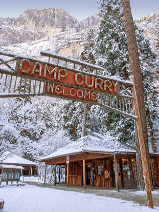
Sherri met Lindy B through a social networking site. They sort of noticed each other because of a mutual love of backpackpacking and backpacking long distances. Libdy B, Blue Butterfly on the Trail, has done the PCT and now is doing a return engagement to do the JMT. So we invited her to spend a night in Fresno before taking her on up to Yosemite. In Yosemite, we stopped by historic Camp Curry. See Adventure 003, Hike 027 for more info.


Adventure 003, Site 027-Camp Curry Historical District

Gary and Lindy B at Camp Curry
Capture California, the Game-2013
Adventure: 003, Site 027-Camp Curry Historical District
National Registry ID: 79000315

Team: YOLT
Date:  August 8, 2013
Location:
Address: Yosemite Valley

Description:
Date Built: 1899
Architect: David and Jennie Curry


From NoeHill
When the camp first opened in 1899, there were canvas cabins, and a dining area. Much of this was destroyed in a 1912 fire. Today, there are around 400 tent cabins. Only the old registration cabin remains of the original buildings. But the iconic Camp Curry entrance sign, built in 1914 by Foster Curry, also remains to greet visitors. We did not see any sign that last year's Hantavirus outbreak affecting the popularity of this area.


By looking at this area, you can see how the relationship of concessionaires with the park service have evolved. From encouraging concessionaires to bring in visitors, to wanting to control the area. In an 1870 pamphlet, Whitney described the battles the original white inhabitants had, trying to keep the Valley for their own enjoyment and profit. Even today, this happens with a decade ago McDonalds proposing a concession for their golden arches.


We visited the camp, even stopping into the mountaineering store to pick up supplies for our JMT friends, Lindy and Ann. They will be sleeping in the backpackers camp while Sherri and Gary head back to Fresno. So sleeping in Camp Curry will have to wait for another day—we did sleep here 32 years ago, though.


References:


Overall Landmark References:

Adventure 011, Tagged Person 028, Ann U

Sherri, Gary and Ann U at the Glacier Point Trailside Museum
Capture California, the Game-2013
Adventure: 011, Tagged Person 028, Ann U
Team: YOLT
Date:  August 8, 2013
Location: Glacier Point, Yosemite
Description:
We only met Ann U the night before going to Yosemite. She came into Fresno to hike the John Muir Trail with a friend of Sherri's—Lindy B. So we were able to give her a mini-tour of Yosemite, wich included the historical Glacier Point Trailside Museum See Adventure 003, Hike 026 for more info.


Adventure 003, Site 026-Glacier Point Trailside Museum

Sherri, Gary and Ann U at Glacer Point Trailside Museum
Capture California, the Game-2013
Adventure: 003, Site 026-Glacier Point Trailside Museum
National Registry ID: 78000357

Team: YOLT
Date:  August 8, 2013
Location:
Address: E of El Portal in Yosemite National Park


Description:
Date Built: 1924
Architect: Herbert Maier and Ansel Hall

We visited Glacier Point because we were hosting two out-of-state JMT hikers before they leave for the JMT Friday. They had not been to Yosemite before, so what better way to show them the wonders of Yosemite but by giving them a birds-eye view of the area where they will be starting their hike? Glacier Point fits that bill since you can see Happy Isles, Vernal and Nevada Falls, Half Dome and up into the Sunrise Creek drainage—just where we came a few days ago.

As we went out to the point, we saw the historic Glacier Point Trailside Museum. Right now this is not much of a museum, but at one time, it was the first permanent teaching “instrument” of its kinds in the whole Park Service-a trailside museum. It also was an important representation of the Rustic style of development of structures.

Originally, this structure was used to to show how glaciers had carved out the Valley and the surrounding domes. It was a branch of the Yosemite Museum, having its funding through the Yosemite Natural History Association. In 1927, over 15,000 people visited this museum. Over the years, it was convert into an office with a view, and what a view. Now, it has a small display showing glacial formation of the valley—returning back to its original purpose. We will also say that it gives visitors a great view of what is each of Glacier Point.


References:


Overall Landmark References:

Adventure 009, Bridge 008-Happy Isles Bridge


Sherri and sign
Capture California, the Game-2013
Adventure: 009, Bridge 008-Happy Isles Bridge
Happy Isles Bridge
Team: YOLT
Date:  August 8, 2013
Location: Yosemite Valley
Description:
Sherri and Gary have walked over this 126' long bridge. Most of the time, the name given to the area by John Muir is appropriate—Happy Isles. This is because the Merced River passes under it, singing it way through Yosemite Valley. But this evening, the Merced is on a slow and low course through the Valley. We still enjoy the evening walk with our friends Lindy B and Ann U across the bridge.
This bridge used to see a lot of vehicular traffic. Now it is and Valley's shuttle buses and an occasional car bearing disabled plates. And of course, the thousands of visitors each day which walk the bridge to see Vernal Falls.

From the application to be on the National Registry of Historic Places:
The Happy Isles Bridge on the Happy Isles Road was built in 1929 with one span of 75 feet (23 m) and two equestrian subways in its abutments similar to those of the Clark Bridge, its near twin. The bridge's total length is 126 feet (38 m). Cost was $46,673.03.