Capture Calif

Capture California

What is a YOLT? Well, you may have heard the term YOLO. Gary and Sherri think we can live again, not as James Bond, but as being reborn. Consequently, we are having fun in our life, after all, You Only Live Twice.

Monday, July 30, 2012

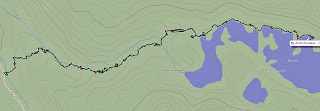
Adventure 008, Hike 047– Goddard Canyon to Florence Lake Overlook

Capture California, the Game-2012
Adventure: 008, Hike 047 – Goddard Canyon to Florence Lake Overlook
Team: Thing One, Thing Two
Date:  July 30, 2012
Location: Kings Canyon National Park
Hike Info:
Trail: Goddard Canyon
Distance:16.1 miles
Duration: 11:20
Elevation Rise: 1,191'


Description:
Got up and went for a short walk with The Cat in the Hat. First we went up and saw the falls Thing One remembers as being spectacular—it was not. What Thing One remembers was a deep gorge with a water fall of 50' or so dropping straight down. What we saw was the river cascading down. We then went down stream a ways to where a creek fed into the San Joaquin. This was closer to the falls Thing One remembered—the vertical drop. Really nice. This was just a prelude to what we would see today.


We were talking about do we want to try to make it to Florence by 5 when the last ferry leaves our end of the lake? Or take the first ferry out. We decided that the 17-18 miles was a bit of a stretch for us right now, even though almost all of it would be downhill. So we did not get an early start—about 8:30 or so.


As we go down Goddard Canyon, we follow the San Joaquin River. It has cut through the stone, leaving a series of small but heart-refreshing waterfalls along the way. It seemed like ever half mile or so, there was a fall which we had to stop and take a picture of. Just downright drop-dead-gorgeous.


We are making faster time than we anticipated. So about 10 we are wondering can we make it to Florence in time. Will our stamina give out? We are also making comments like, we are glad we are going down this rather than up. But looking at the topo map, it is not as bad as the climb into Evolution Valley.


A little bit after noon, we reach the intersection with the JMT/Evolution Valley. We are making good time, but we need to stop for lunch and water. It is starting to get hot again and we will be going down the hot section of the trail—see the notes from July 25th and 26th. But we still are in relatively good humor and feeling strong. So on we go.


As we continue down the canyon, we retrace our steps from four days ago. It is still rocky, it is still hot. But we make it to Piute Creek, the border of the National park and the National Forest. There is a pack train, stretched across the train—not along the trail and the pack leader does nothing to move the beasts. So we need to go around through the manzanita—getting pretty scratched up along the way—still think pretty bad thoughts about the pack master. Also the pack master gave out some very bad information about the last ferry and distances—information we knew was wrong. We stop at the creek and evaluate—we do know, even without the pack master mis-information—that we will not make it to the ferry. It is 3pm. So we slow down a little.


As we come down, Thing One needs to take a leak and go off the trail a little way. Thing One find a cabin marked as the John Muir Cabin—this is different than the John Muir Hut on top of Muir Pass. The cabin looks a bit run down, some of the floorboards are missing and there is trash in the cabin. But Thing One supposes if you needed shelter in a storm, this would work.


We continue on down the trail. Thing One thinks we have decided to stop for a break when we rejoined the San Joaquin—but Thing Two and The Cat in the Hat had other ideas and were pretty upset at Thing One when he stops. We pass by the John Muir Ranch and Blayney Meadow. We stop and have dinner at a small creek. Nice affair. We decide to continue on for a ways, but filling up our water.


We get a little ways from the trail junction where you go down to the ferry or hike around the lake. There is a campsite, up on the ridge, overlooking the San Joaquin. We decide that we have enough water on us and we only need to do breakfast, that we would do a dry camp up here. Very nice view and we need the rest.


Adventure 056- Hammock

Capture California, the Game-2012
Adventure: 056 - Hammock
Team: Thing One, Thing Two
Date:  July 31, 2012


Location: San Joaquin River
Description:
The Cat in the Hat really enjoys here sleep. She also knows that one of the best places to get her sleep is in her hammock. Rather than carry a tent backpacking, she snuggles down in her hammock, with the protective mosquito netting and sleeps and sleeps and sleeps.


Of course, the hammock has had a long history of providing comfort to those in need of rest. The sailors who crossed the oceans in the 1500's discovered that the hammock's gentle, or not so gentle, sway aided in a good night sleep. But even before then, explorers discovered that the natives to the Caribbean islands tied fish net between two trees to sleep on. In fact, the word hammock comes from the Haitian word for fish net. These West Indies, and later on discovered throughout Central and South America provided a degree of protection from animal, inset, and snake bites by being off the ground.


But does the Cat's hammock keep her safe from Thing One and Thing Two?

P.S. Cats never drool!


Sunday, July 29, 2012

Adventure 008, Hike 046 - Davis Lakes to Goddard Canyon

Capture California, the Game-2012
Adventure: 008, Hike 046 – Davis Lakes to Goddard Canyon
Team: Thing One, Thing Two
Date:  July 29, 2012
Location: Kings Canyon National Park
Hike Info:
Trail: Cross
Distance: 5.8 miles
Duration: 12:30
Elevation Rise: 1,098'


Description:
Got up at first light and hit the trail at 7:30. More boulders and more slow moving. Thing Two has gained some experience and is moving better. As we move along the lake, we realize just how huge this lake is. Also with the mountain backdrop, how breath-taking this area is. Davis Lake is so clear and we are the only ones here.


This part of of our write up is written from memory. Thing One was so tired—poor big thing, that it was hard for him to put pen to paper and have the words come out intelligible. Once free of the boulder field—The Cat in the Hat and Thing One did continued their system of ferrying Thing Two's pack. We have not gone far, but there has been a lot of effort. Now we are faced with a talus slope of at least 30-40 degrees. And this is a long stretch. But once across this stretch, we should be in good shape. It turns out that once we climb about a hundred feet or so, there is a pathway across the talus slope. And it is pretty level without much give under our feet.


At the end of talus field, we are about three-quarters of the way around the lake, but we will be leaving the lake here. There is a small saddle above us. But before this, we get a splendid view across from where we came. The lake is below us by several hundred feet—from this height you can see almost everything about it. We would not be able to continue on around the lake on our side because of the cliffs coming down to the lake and the falls on the other side. The other side of the lake has even more impressive cliffs. So it is up and over the saddle.


This is easier to do on the map than in reality. We start climbing up the saddle and think we are following a cross country trail—in retrospect, we probably are, but when we come across a ridge, it looks like the path will take us on a pretty shear path, one which Thing One is not sure he wants to walk on. So we stop at this pond close to the saddle. It is idyllic. If we had enough food and time, Thing One would say camp here. The pond is really deep—you cannot see the bottom, even though the water clear. We have lunch on a strip of grass and just enjoy the soft breeze blowing. But we need to continue on and we have much of the afternoon left.


Thing One goes on and finds an easy, bouldering path over the saddle. His memory of this area after 40 years is shot and the things Thing One remembers is not very reliable. But after crossing this saddle, we have a nice easy meadow to go down for a quarter mile. But at the end, there is a steep drop, maybe 400' down. While it looks manageable, it will be slow going. There is one place where we need to take care and just go down a handhold at a time. The Cat in the Hat is doing double work by ferrying Thing Two's pack. But down we get.


And when we do, it is beside Goddard Creek—this is not to be confused with Goddard Canyon which has the San Joaquin River running down it. Goddard Creek empties Davis Lake and we are coming out below the falls which does the emptying. There is a large sloping meadow here and our only task is to cross the creek to get to the other side, then it should be easy walking for a ways.


The Cat in the Hat finds some rocks to cross, but Thing Two is unsure about this, so Thing One goes a little farther up creek to see what he can see. Out of the corner of his eye, he sees movement and a flapping of wings next to the falls. When he looks over, this bird has a huge wingspan. His guess from the distance, about 150 yards or so, the the wingspan if 5-6'. It has swooped down onto the south side of the creek. The head is white and the body looks black. Sounds like a bald eagle to Thing One. After a minute or so on one side, it flaps up and lands on the north side of the creek. Thing One suspects it has caught a fish. After a minute, it flies away. Unfortunately, Thing One could not get the camera focused on the bird and only got a blurry shot of him flying off.


By this time, Thing Two and The Cat in the Hat has crossed the creek and Thing One excitedly joins them. They have a small bird chirping close to them—which Thing One gets a good picture of. But Thing One can only tell them about the eagle. It is now more down the creek time and the canyon we are in is getting steeper. Thing One sees where he thinks he probably crossed 40 years ago. But this is after we have had another good slope to descend. But on this descent Thing One does find a broken plant and a foot print. So at least someone else has been down this way. We cross a little river-let and it looks like there is almost a path. This leads us on for a ways—right up the side of a cliff. There definitely is a path here which others have taken, but where it goes from here, we are at a loss. After examining the options, we decide, there is a small crack in the rock and The Cat in the Hat goes up it. She says that we can descend on the other side. So off comes our packs and we push them on up. Thing Two has her first chimney under her belt now.


But it is getting late and we are at least a mile, cross-country from the Goddard Canyon trail. We decide that if we do not get down by 8, we will camp. We start our descent again—this time, it is a lot tamer from what we have gone on. But it tame only in comparison. It is still rough. We go up and over a second ridge—this time it is easy. We are able to look into Goddard Canyon and the San Joaquin River. Now the only task is to get down. The Cat in the Hat leads the way and Thing One work as a guide for Thing Two. For the most part, it is more just picking our way down. And down we get as we reach the river at 8. We start pitching the tent and hammock in the dark while Thing Two cooks our meal. We will find the trail tomorrow. We turn in pretty much as soon as after we eat, all tired from yesterday.


Adventure 105 - Bald Eagle

Capture California, the Game-2012
Adventure: 105 – Bald Eagles
Team: Thing One, Thing Two
Date:  July 29, 2012
Location: N37.7.50.06, W118.44.26.13 (Goddard Creek, west of Davis Lakes)


Description:
Beauty and grace are performed whether or not we will
or sense them. The least we can do is try to be there.
Annie Dillard, Pilgram at Tinker Creek, pg 287
(The Annie Dillard Reader)


Sometimes you stumble upon beauty when you are looking for the prosaic. That is what happened to Thing One. We were looking for a good place to cross Goddard Creek without getting our feet wet. We had already spent a long time getting around Davis Lakes and coming down a steep slope to get to the creek. The Cat in the Hat had found a way across but Thing Two was a bit leery of it. So Thing One wandered upstream a little ways.


Out of the corner of his eye, close to the base of a 40' cascade, he saw something big come down at the base of the cascade, on the south side. It looked like it had a 5-6' wing-span and for a a couple of seconds, he thought it was the biggest raven he had every seen, since it looked completely black. But then, Thing One saw his head and it was white. Could it be? Is this a bald eagle. Then he took off and came back down on the north side of the creek. By this time, Thing One was trying to get the eagle focused. But by the time he did, the eagle had completed his fish meal and took off to fly towards the west, leaving Thing One with only a couple blurry pictures of an eagle in flight, with the sun glistening from his body.

Saturday, July 28, 2012

Adventure 008, Hike 045 - Sapphire Lake to Davis Lakes

Capture California, the Game-2012
Adventure: 008, Hike 045 – Sapphire Lake to Davis Lakes
Team: Thing One, Thing Two
Date:  July 28, 2012
Location: Kings Canyon National Park
Hike Info:
Trail: John Muir Trail and Cross Country
Distance: 4.4
Duration: 10:48
Elevation Rise: 1,044'


Description:
We get up at 6:30 or so. The wind is blowing but not as strong. We hit the trail at 7:40 and start our 400' climb to Wanda Lake. We cover the 1 ¾ miles in an hour and a quarter—it is not a bad climb, but we are over 11,000'. It is a nice temperature and we make good progress.


We stop when the trail crosses the creek below Wanda Lake and have a break. It is so wonderful looking back down the canyon. Even with it with a series of unnamed lakes. The sloping ground and the cut off of the land below our view.


But it is time for us to start our cross-country adventure. We will be going up to a small 11,700' saddle and then drop down into Davis Lakes. 40 years since I have been here. We make it up to the saddle pretty good. But now we start going down. It is a boulder field all the way down to Davis Lakes and Thing Two does not like it. The mountains are a good backdrop and anytime we want to breath, they are there to admire—ie, a good excuse for Thing One to stop and breath.


But the boulders are a calling and they are there to hamper our progress. It consumes a lot of energy and time going up and over and around them. Plus, we are going on a pretty steep incline as well. Thing Two is a bit spooked by then. I help her before lunch. After lunch, Cat in the Hat works with her. She does really good with Thing Two. Even when we get to the lake. There are boulders and a cliff which force us to go high. We come back down a ravine, which gets progressively steeper. We eventually get down to the lake, but the shore disappears and there is 8' of rock cliff which we scoot along in the water. Thing One is in his boots and is able to hop from low rock to low rock. The others are bare feet or Teva's. We are tired, but not sure where we can camp. So we trudge on. The Cat in the Hat does find a place on a peninsula  and we decide to settle down by Davis Lake for the night. It is a beautiful lake. We even have a little bit of energy and spirit to play a short came of catch with the frisbee.


Trail Lesson: Fear is a mind killer—Bene Gessart saying from Dune.


Friday, July 27, 2012

Adventure 066 - Kite Flying


Capture California, the Game-2012
Adventure: 066 – The Kite Fly
Team: Thing One, Thing Two
Date:  July 27, 2012
Location: Sapphire Lake

Description:
Let's go fly a kite
Up to the highest height!
Let's go fly a kite and send it soaring
Up through the atmosphere
Up where the air is clear
Oh, let's go fly a kite!
--- From Mary Poppins
Composed by Richard M Sherman
and Robert B Sherman


We suspect that most teams go to the beach to fly their kite. Or go to their local park. But team Thing One, Thing Two decided to take the phrase from the Mary Poppin's song literally and try to fly our kite Up to the Highest Height. So we climbed to Sapphire Lake at 11,140' where we camped. A stout wind blew—maybe a little two much for our little para-foil kite. But with much fun and a bit of weariness from our day of backpacking, the Cat in the Hat got the kite aloft and flying. So team Thing One, Thing Two lay claim to flying our kite the highest!


Adventure 008, Hike 044 – Evolution Meadows to Sapphire Lake

Capture California, the Game-2012
Adventure: 008, Hike 044 – Evolution Meadows to Sapphire Lake
Team: Thing One, Thing Two
Date:  July 27, 2012
Location: Kings Canyon National Park
Hike Info:
Trail: John Muir Trail
Distance: 8.9 miles
Duration: 10:00
Elevation Rise: 2,307'


Description:
We have breakfast and Thing Two hits the trail at 9:20. The Cat in the Hat and Thing One follow shortly. We pass through Evolution Meadow, the least of the three meadows in Evolution Valley. Making good time. But we start climbing up a ridge and get to McClure Meadow.


This meadow is just so pretty. You get the idea of a perfect Valley It is some place which you can spend time just admiring. We do not do it justice. Just before Colby Meadow, we catch up with Thing Two and take a break.


This starts our leap frogging of a Japanese man--older with limited English. We would pass him several times. Very courteous. Later it looks like he was hobbling and we offer moleskin, but he says he does not have blisters.


The JMT book sad we might need to wade one creek. But it was pretty low so we crossed o a log. Then the start of our steep 800' climb. Coming up the Valley, we already rose up 900'.


We spot a couple of waterfalls and head over there. Thing One borrow Thing Two's Teva's and go under the falls—cold--not shocking cold. But it did get the heart racing. The Cat in the Hat did the same thing after Thing One was through.


We are hot and slow. But there is enough eye candy, mostly The Hermit, to keep us going. The U-Shape of the Valley gives a peaceful feeling. The altitude is also working against us. We are about 10,000' now. Well that is except the energizer bunny—The Cat in the Hat--who still has a bounce in her step.


By the time we get to Evolution Lake, it is 4. Thing Two is still good for Sapphire Lake. So we start the 2 mile, 200' trek there. The Cat in the hat goes ahead to find a camp site. In contrast with the warmth of the day, the falling evening shadows send a chill through us. Then with the breeze, it is getting downright cold.


The site The Cat in the Hat has found is by the Lake, smooth enough to pitch our tent. So The Cat in the Hat will sleep with us tonight. Good thing she bought us a 3 person tent. While dinner is being made, The Cat in the Hat and Thing One go fly a kite—at 11,000' for our Capture California points. We eat, clean up and watch the sun set—or more accurately, we see the light leave the surrounding mountains.


Trail Lesson: Waterfalls are a great source of refreshment—both visual and when you personally plunge in.