Capture Calif

Capture California

What is a YOLT? Well, you may have heard the term YOLO. Gary and Sherri think we can live again, not as James Bond, but as being reborn. Consequently, we are having fun in our life, after all, You Only Live Twice.

Saturday, September 28, 2013

Adventure 003, Site 089-Mission Carmel

Sherri at Mission Carmel

Mission Carmel
Capture California, the Game-2013
Adventure: 003, Site 089-Mission Carmel
California Landmark Number: 135
National Registry of Historic Places ID: #NPS-66000214


Team: YOLT
Date:  September 28, 2013
Location:
Coordinates: 36°32′33.6258″N, 121°55′11.0496″W
Address: 3080 Rio Rd. Carmel-by-the-Sea, California


Description:
Date Built: June 3, 1770


See Adventure 068 for a little bit about our adventure this year. Also, we visited this mission last year and got some interesting information about Mission Carmel.


NO. 135 MISSION SAN CARLOS BORROMÉO DE CARMELO - Mission San Carlos was established by Father Serra on June 3, 1770 at the Presidio of Monterey. Finding this location unsuitable, Serra moved the mission to Carmel Valley. In July 1771 he set to work constructing temporary buildings at the new site, and in December 1771 the mission was moved to its permanent location.
Location: SW corner of Lasuen Dr and Rio Rd, Carmel


References:


Overall Landmark References:


Adventure 215, Park 05-Julia Pfieffer Burns State Park

Gary and Sherri at Julia Pfieffer Burns State Park
Capture California, the Game-2013
Adventure: 215, Park 05-Julia Pfieffer Burns State Park

Team: YOLT
Date: September 28, 2013
Location: Julia Pfieffer Burns State Park

Description:
We did a hike and looked at McWay Falls while at this park.

Adventure 215, Park 03-Big Sur Lighthouse

Gary at the closed gate of Point Sur SHP
Capture California, the Game-2013
Adventure: 215, Park 03-Big Sur Lighthouse

Team: YOLT
Date: September 28, 2013
Location: Big Sur

Description:
What a beautiful day! Sun shining, the ocean shimmering and the greens of Point Sur calling us. What a beautiful day! Evidently more than just us thought so also as the gate was closed and the tour was full. Oh well. At least we came and were able to research some of the history of this beautiful place in Adventure 3, Site 086.


Adventur: 119-McWay Falls

Sherri at McWay Falls
Capture California, the Game-2013
Adventure: 119-McWay Falls

Team: YOLT
Date:  September 28, 2013
Location: Julia Pfieffer Burns State Park

Description:
This is one of the most scenic places in California. Not too much more can be said about it. Probably one of the best things was a comment Gary's Mom said last year. When we were telling them that this is one of the prettiest falls in California. The comment was we have seen a lot of pretty falls in California, but then when seeing the falls, they concurred about its beauty. We experienced it again this year.


Adventure: 003, Site 088-Nitt Witt Ridge

Sherri at Nitt Witt Ridge
 Capture California, the Game-2013
Adventure: 003, Site 088-Nitt Witt Ridge
California Landmark Number: 939


Team: YOLT
Date:  September 28, 2013
Location:
Coordinates: 35° 34.066′ N 121° 5.848′ W
Address: 881 Hillcrest Drive, Cambria, Ca


Description:
Date Built: 1928, onward
Architect: Arthur Harold Beal, aka Der Tinkerpaw, aka Capt Nitt Witt


Last year we heard about this place and just had to visit it then. It was close to dusk then, so the house did not show its true form. But even then, it was one of those places which left you in awe of the person who had the gumption to build it.

Assorted Stuff
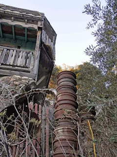
This year, we arrived in enough time to enjoy looking at the house, behind a chain link fence. Now we could see some of the features and take a clean picture of it. From the porcelain toilets to the tower of hubs, you think a couple of thoughts. The first, this man had a genius for recycling. The second is close by with we are glad he was not our neighbor. After seeing the house, we continued on the road, which circled above the house. It was interesting seeing the upper-middle class homes of his back neighbors, just the contrasts of styles.


Tower of Hubs


NO. 939 Twentieth Century Folk Art Environments (Thematic) -NITT WITT RIDGE - Nitt Witt Ridge, one of California's remarkable Twentieth Century Folk Art Environments, is the creation of Arthur Harold Beal (der Tinkerpaw or Capt. Nitt Witt), a Cambria Pines pioneer, who sculpted the land using hand tools and indigenous materials, remarkable inventiveness, and self-taught skills. A blend of native materials and contemporary elements, impressive in its sheer mass and meticulous placement, it is a revealing memorial to Art's unique cosmic humor and zest for life.
Location: Nitt Witt Ridge, 881 Hillcrest Dr, Cambria Pines


References:


Overall Landmark References:


Adventure 003, Site 086-Big Sur Lighthouse

Gary at the closed gate of Point Sur
Adventure: 003, Site 086-Big Sur Lighthouse
California Landmark Number: 951
National Registry of Historic Places ID: 91001097


Team: YOLT
Date:  September 28, 2013
Location:
Coordinates: 36°18′18″N 121°53′55″W
Address: St Hwy 1, 23 mi S of Monterey and 3 mi N of Andrew Molera St Pk


Description:
Date Built: 1889


This lightstation is the only turn of the century lightstation which is open for for public viewing in California. It shows in that its tours are fully booked on many days, as it was today. But coming up later in October is one of the top haunted lighthouse tours in the United States. The lightstation, to its credit, is still running, but it is fully automated. Until that time, the large Fensel lenses would guide the boats away from the dangers awaiting them on the point.


A whole catalog of ships have sank on the rocks of Point Sur. The most famous being Ventura in 1875. It was this wreck which caused the Point Sur light station to be funded. Other ships includes: the LOS ANGELES in 1894, the MAJESTIC in 1909, the SHNA-YAK in 1916, the THOMAS L. WAND in 1922, the BABINDA in 1923, the RHINE MARU, the PANAMA and the S. CATANIA in 1930, and the HOWARD OLSON in 1956. But it is not only the ships which glide across the water which has had their issues. The dirgible stationed at Moffet field, the USS Macon crashed off the shores of Point Sur in 1935.


Besides being a lightstation, it listens. The US Navy during the Cold War used Point Sur as a sonar listening post, listening for Soviet submarines. Even today, the Navy has a precencse on the site with its one building, still listening and protecting us.


NO. 951 LIGHT STATIONS OF CALIFORNIA (THEMATIC), POINT SUR LIGHT STATION - Spanish explorers and later New England hide and tallow traders found the Big Sur coastline a great hazard. Heavy fogs and extreme winds caused the wreck of many vessels on this coast. The gold rush of 1849 dramatically increased coastal shipping. A lighthouse was clearly needed. President Andrew Johnson signed the Executive Order which reserved the site for lighthouse purposes in 1866. Construction began in 1887 and the lamp was lit on August 1, 1889.
Location: St Hwy 1, 23 mi S of Monterey and 3 mi N of Andrew Molera St Pk


References:


Overall Landmark References:


Adventure 005, Hike 059-McWay Falls

Gary and Start of McWay Trail

Pelton Waterwheel

Tunnel View
Capture California, the Game-2013
Adventure: 005, Hike 059-McWay Falls

Team: YOLT
Date:  September 28, 2013
Location: Julia Pfieffer Burns State Park

Hike Info:
Trail: McWay Trail
Distance: 0.75 miles
Duration: 0:30 Moving
Elevation Rise: 50'


Description:
This hike is a bit below our standards for length, but well above our standards for beauty. We left our car and walked under a bridge. Over the years, we have enjoyed this hike. Our first stop was to examine the Pelton Waterwheel. This enabled the Burns family to be the first in the area to have electricity. A Pelton Waterwheel has double scoops, which increases the power generated. The ranch foreman did research before deciding to use this type of waterwheel generator. As a note, last year we visited a competitor of the Pelton waterwheel in the gold country.
After seeing the waterwheel, we went through the tunnel, going under Highway One. A great view of the ocean in the late afternoon sun. Then onto the overlook, looking at McWay Falls. We discovered this trail and falls several years ago and have been enjoying it almost every year since. We do remember the falls falling directly into the ocean. But there has been a slide a couple miles north of the falls, causing more dirt and gravel to build up on the beach.
After gawking at the falls, we move on to the former house site of Julia Burns. Then we retrace our steps back to the car.


Adventure 068, Mission 01-Mission San Carlos Borromeo de Carmelo, 2nd mission


Capture California, the Game-2013
Sherri at Mission Carmel

Adventure: 068, Mission 01-Mission San Carlos Borromeo de Carmelo, 2nd mission

Team: YOLT
Date: September 28, 2013
Location: Carmel

Description:


This mission is always busy. Between the tourists, such as ourselves, and the regulars the parking lot was full, even on a Saturday. There seemed to be a special event going on here. So we took a few pictures and continued our ride down the Central California coast. For more on Mission Carmel, particularly about Father Junipero Serra, see our blog entry from last year.


Mission Carmel

Adventure 005, Hike 060-Moonstone Beach

Sunset at Moonstone Beach
Capture California, the Game-2013
Adventure: 005, Hike 060-Moonstone Beach

Team: YOLT
Date:  September 28, 2013
Location: Cambria

Hike Info:
Trail: Moonstone Beach
Distance: 1.75 miles
Duration: 1:00 Moving
Elevation Rise: None


Description:
This is probably our favorite evening walk. We started our walk at a different place than usually-Shamel Park close to Cambria. Our walk took us among the dunes at sunset—some really exciting sites. Then we crossed a small pool—in some mud—and climbed up to the Moonstone Trail Boardwalk. This goes along the short cliffs. Many people enjoy this walk in the evenings-couples, children, dogs, and the elderly all were out walking. While not getting all the way to the end, we needed to turn around because it was getting dark., and we were without a light. Besides, it was time to head over to Main Street Grill for dinner. So off we went. Instead of returning via the dunes, we came back around the east side of a creek and walked about a third of a mile down a street back to our car.


Adventure 215, Park 04-Julia Pfeiffer Big Sur State Park

Sherri at Big Sur
Capture California, the Game-2013
Adventure: 215, Park 04-Julia Pfeiffer Big Sur State Park

Team: YOLT
Date:  September 28, 2013
Location: Carmel

Description:
As we continued our trip down the coast on Highway One, we came to Big Sur State Park. We debated about going in, because of lack of time to do what we love, like hiking. But to see a tall tree, that is always a great thing to see. So we went in for a brief visit, but then left shortly afterwards.


Adventure 009, Bridge 010 – Wildcat Creek Bridge


Capture California, the Game-2013
Adventure: 009, Bridge 010 – Wildcat Creek Bridge

Team: YOLT
Date: September 28, 2013
Location: Highway One, South of Carmel

Description:
It is so interesting walking the bridges along Highway One. For one, the scenery is top-notch. But even more intersesting is when you look below the bridge. What do you see? Under the Wildcat Creek Historic Bridget, you see, well a creek, meandering through a canyon. Lots of trees, and ocean, and, oh yeah a pool. Like I said, interesting what a short walk across a bridge can bring you.
So a few interesting facts about Wildcat Creek Bridge:
  • Location: Monterrey County, just south of Point Lobos (+36.49771, -121.93596 ). There is another bridge in Contra Costa County with the same name.
  • Built: 1933
  • Type: Closed-spandrel concrete arch. You might ask, what is a spandrel? It is the triangle area beneath the roads surface and above the arches.
  • Length: 165', with the longest span being 57.1', width: 34.1'
  • Bridge ID: CA 44-16
  • Average daily traffic: 13,000 vehicles
  • Quirkiness: This is the only pointed-arch spandrel bridge in California.
  • Quirkiness #2: the spandrels, the space between the curves of the arches, are filled in with rubble and finished with concrete, stone, or a mixture of both

Adventure 215, Park 02-Pt Lobos State Natural Reserve

Capture California, the Game-2013
Adventure: 215, Park 02-Pt Lobos State Natural Reserve

Team: YOLT
Date: September 28, 2013
Location: Pt Lobos State Natural Reserve

Description:
While we have not had enough experience to back up this claim, Francis McComas, landscape artist, says that Pt Lobos is the The greatest meeting of land and water in the world.
Last year we visited this park and fell in love with it. The love affiar started with us seeing whales for the first time. But then was enlarged with seeing the moss covered trees, the ragged rocks and the waves crashing against the cliffs.
This year we enjoyed walking under a bright sun, seeing both mammal, bird, and adquatic life. Even scored a few Capture California points:


References:

Adventure 005, Hike 058-Pt Lobos Trails

Sherri on the Trail

Lonely Cypress
 Capture California, the Game-2013
Adventure: 005, Hike 058-Pt Lobos Trails

Team: YOLT
Date:  September 28, 2013
Location: Pt Lobos State Natural Reserve

Hike Info:
Trail: Two trails-Cypress Grove (.8 miles), South Shore Trail (2 miles)
Distance: 2.8 miles
Duration: 1:00 Moving


Description:
After having our picnic lunch, overlooking the ocean, it was time to go and see what we could see. So we started on the South Shore Trail and headed north-we were already at a parking space to the south. The trail followed the coastline, showing fissures into the ocean. From here we spotted cornanents and seals and gulls, and maybe a falcon. The sun on the water gave a magical effect to this walk. The walk was pretty easy with a few stairs along the way. We then hit the Sea Lion Parking Lot.


Sunning sea Lions
From this parking lot, we took the Cypress Grove Trail. As appropriate, we started seeing cypress tress right away. Interesting that the area had splatches of orangest colored lichen—on rocks, on the ground and on the trees. But on this hike, we even stopped to look for whales—see the results in Adventure 037. But the highlight of the trail is the cypress trees. Just how they look against the blue ocean.


Comerants
References:


Adventure 037 – Watch a Whale

Sherri, the Whale Watcher
Capture California, the Game-2013
Adventure: 037 – Watch a Whale

Team: YOLT
Date: September 28, 2013
Location: Pt Lobos State Park

Description:


Last year while at Pt Lobos, we saw our first whales while looking out across Carmel Bay from Whaler's Cove. This was such an experience for Sherri and Gary. Much better than looking at the model whales at the Monterrey Aquarium like we did the year before. This year we visited Pt Lobos again, with the hope of seeing more of these giants of the sea. What did we see? Take a look at the video.

Adventure 003, Site 087-Sebastian's Store

Sherri and Sebastian's Store

Sherri and the plaque
Capture California, the Game-2013
Adventure: 003, Site 087-Sebastian's Store
California Landmark Number: 726


Team: YOLT
Date:  September 28, 2013
Location:
Coordinates: 35°38′36″N 121°11′29″W
Address: San Simeon Rd, San Simeon


Description:
Date Built: 1852


This is turning into an annual pilgramage on our coast drive.


NO. 726 THE SEBASTIAN STORE - This is the oldest store building along the north coast of San Luis Obispo County. Built in the 1860s at Whaling Point, one-half mile to the west, it was moved to its present location in 1878. It has been operated by the Sebastian family for over half a century.
Location: San Simeon Road, San Simeon


References:


Overall Landmark References:


Adventure 215, Park 07-WR Hearst State Park

Capture California, the Game-2013
Adventure: 215, Park 07-WR Hearst State Park

Team: YOLT
Date: September 28, 2013
Location: San Simeon

Description:
Across Highway One from Hearst Castle which few people visit. But it does have a great beach and a lovely pier. Also if one looks hard enough, you can find a hiking trail. But today, we only had time to enjoy the pier.


Adventure 219, Pier 01-San Simeon Pier

Capture California, the Game-2013
Sherri on San Simeon Pier

A pier without peer
Adventure: 219, Pier 01-San Simeon Pier

Team: YOLT
Date:  September 28, 2013
Location: San Simeon


Description:
So what is a Southern California pier? That was a question we asked ourselves. From a NorCal boy like Gary, Fresno seems about the extent of being north. So San Simeon by default is south. But we will let the judges decide that one.

For us, this pier is one of fascination. We have spent hours watching the various birds-gulls, herons, pelicans and cormorants dive and pull up fish. We have spent quiet times of watching sunsets from here and as well as just enjoying the ocean breeze. So whether it is eligible or not, this is our pier without peer.


Adventure 215, Park 06-Limekiln State Park

Gary and Sherri at Limekiln
Capture California, the Game-2013
Adventure: 215, Park 06-Limekiln State Park

Team: YOLT
Date: September 28, 2013
Location: Limekiln State Park

Description:
With the sun starting to set and us wanting and see a couple of things at San Simeon and Cambria, we could only stop and think about some past hikes and falls we had seen at Limekiln. Limekiln has some deep ravines which darken early. So the walks there are best in the early afternoon, not as the sun sets. Some previous times at Limekiln includes:


Adventure 053 – Picnic Outside

Picnicing at Pt Lobos

View from our picnic bench
Capture California, the Game-2013
Adventure: 053 – Picnic Outside

Team: YOLT
Date: September 28, 2013
Location: Pt Lobos State Park

Description:


What a spot we had for our picnic. See our Adventure 133 writeup.


Adventure 133-Picnic at Pt Lobos

Lunchtime at Pt Lobos

View from our picnic bench
Capture California, the Game-2013
Adventure: 133-Picnic at Pt Lobos

Team: YOLT
Date: September 28, 2013
Location: Pt Lobo State Park

Description:


It was a pretty glorious day. Gary had just come back from Hawaii and we had visited his parents in the Bay Area. So now it was time to come back to Fresno. But how to go? We decided to come down the coast instead of over Pacheco Pass.
So we stopped in Castroville and picked up a Subway sandwhich-an Italian B.M.T. to be particular. Then headed down. One of the first places we stopped was Pt. Lobos. It was noontime. So we found a bench overlooking a cove and enjoyed the sights and the ocean smell. Pretty nice.


Wednesday, September 18, 2013

Adventure 141, Center 04-Merced Welcome Center

Gary and the Merced Welcome Center
Capture California, the Game-2013
Adventure: 141, Center 04-Merced Welcome Center
Team: YOLT
Date:  September 18, 2013
Location: 710 W 16th St Ste A, Merced, CA 95340-4626
Description:
Our fourth Welcome Center, this time a bit closer to home, and which we visited last year.


Adventure 102-Chief Solano

Chief Solano
Capture California, the Game-2013
Adventure: 102-Chief Solano

Team: YOLT
Date:  September 18, 2013
Location: Fairfield

Description:
This is one of those times which experience does help. Last year while searching for the Chief which Solano County is named after, we hunted all over the place for him. If we had only turned around we would have seen him.
But this year we came, we saw, and we snapped—a picture that is. Chief Solano was one of this Native American figures which causes you to ponder the advance of civilization. For more, see Wikipedia.

Adventure 003, Site 085-Merced Internment Camp

Gary at the Merced Interment Center Plaque
Capture California, the Game-2013
Adventure: 003, Site 085-Merced Internment Camp
California Landmark Number:935
Team: YOLT
Date:  September 18, 2013
Location:
Coordinates: 37° 17.48′ N, 120° 29.104′ W
Address: 900 Martin Luther King Jr. Way, Merced, CA


Description:


Last year we became interested in what happened during World War II to the Japanese -Americans. We visited several internment center sites, including the Merced Fairgrounds. It is moving to see the extent of the forced exile of these people.


From the California Office of Historical Preservation:

NO. 934 TEMPORARY DETENTION CAMPS FOR JAPANESE AMERICANS-MERCED ASSEMBLY CENTER - This was one of 15 temporary detention camps established during World War II to incarcerate persons of Japanese ancestry, a majority of whom were American citizens, without specific charges or trial. From May to September 1942, 4,669 residents of Northern California were detained until permanent relocation camps were built. May the injustices and humiliation suffered here as a result of hysteria, racism, and economic exploitation never recur.
Location: Merced County Fairgrounds, 'J' St at 7th St, adjacent to parking lot at entrance to fairgrounds, Merced

References:


Overall Landmark References:


Adventure 101-Veteran's Memorial

Capture California, the Game-2013

Adventure: 101-Veteran's Memorial

Team: YOLT
Date:  September 18, 2013
Location: Fairfield

Description:
Last year, this memorial was much more moving. There was more memorials available, commemorating each of the wars which the citizens of Fairfield had fought in.
This year, there was a large construction project going on. The only two visible memorials was the one commemorating the army with a machine gun. The other was the I-beam V which celebrated both of the V days in 1945-Victory in Europe and Victory in Japan. The plaques honors those who fought to regain the “Freedom of Speech” by the sacrifice so easily forgotten.

Adventure 100-Highway 40

Capture Ca
Does a sign in Colorado count?
lifornia, the Game-2013

Adventure: 100-Highway 40

Team: YOLT
Date: September 18, 2013
Location: Fairfield

Description:
Earlier this year, we traveled down highway 40 for a little ways in the company of Gary's brother and my parents. It was pleasant enough to be traveling this close to the foothills of the Rockies. But we suspect that you may not want to hear about US Highway 40 in Colorado.
So we did travel to Fairfield, not Connecticut, but California, to visit Sherri's cousin. We saw a highway 40 sign on West Texas boulevard and scored some Capture California Points. By the way, how did this road become West Texas?
Same sign as last year, different person and flag


To read how US Highway 40 became Highway 40, read last year's blog entry.

Tuesday, September 17, 2013

Adventure 008, Doggie 04 – Walk around Neighborhood

Twittering Tuesday Walk with Ritto at University Park
Capture California, the Game-2013
Adventure: 008, Doggie 04 – Walk around Neighborhood

Team: YOLT
Date:  September 17, 2013
Location: University Park, Fresno


Description:
Team YOLT loves to take their dog Ritto for a walk.  When we were doing the Twitter Tuesday on walking into the Day’s End we thought why not take our dog.  It was a win-win situation.   We walked to one of Ritto’s favorite places.  We did a lap around a park  in our neighborhood.  What better way to end a day in Fresno that was only in the 80’s.

Adventure 221, Event 4 – Day's End Walk

Ritto, Sherri, Flag in park at sunset
Capture California, the Game-2013
Adventure: 221, Event 4 – Day's End Walk

Team: YOLT
Date:  September 17, 2013
Location: Fresno


Description:
We almost missed the Day's End Walk. Sort of hard to blame on work or too hurried of a schedule since we are retired. But just more we do a lot of fun stuff and sometimes that crowds out the occasional requirements of life, such as Capture California.

But what we did was to do a walk around our neighborhood to our local park, enjoying the setting sun, walking our dog and talking with our daughter. Of course, something which was enjoyable is the evening air was only in the upper 70's—pretty cool for Fresno at this time of year.

Sunday, September 15, 2013

Adventure 003, Site 063-Liberty Theater

In Front of the Liberty Theater

Capture California, the Game-2013
Adventure: 003, Site 063-Liberty Theater
Local Registry ID: 171


Team: YOLT
Date:  September 15, 2013
Location:
Address: 944 Van Ness Avenue, Fresno


Description:
Date Built: 1917
Architect: W. D. Coates & H. B. Traver


The Liberty Theater opened in November 27, 1917 with a showing of “When A Man Sees Red”. Most recently, it housed the Spanish Evangelical Church. But in May 2011, the Grand Old Opry came to town and played here. So whether Fresnans know the theater as Liberty, Hardy or the Mexicalian, it has seen some pretty classing productions.
Liberty Theater


Liberty Theater (1917)

944 Van Ness Avenue
W. D. Coates & H. B. Traver, Architects

Renaissance Revival

The oldest surviving movie theater in Fresno, the building still displays signage for all three of its names: Liberty, Hardy's, and Mexico.


References:


Overall Landmark References:


Adventure 003, Site 058-Fresno Republican Printery

Sherri in front of the Printery

Capture California, the Game-2013
Adventure: 003, Site 058-Fresno Republican Printery
National Registry of Historic Places ID: 79000474
Local Registry ID: 5


Team: YOLT
Date:  September 15, 2013
Location:
Coordinates: 36°44′01″N, 119°47′11″W
Address: 2130 Kern Street, Fresno


Description:
Date Built: 1919
Architect: Glass & Butner,


Last year, we found out that Fresno at one time had two thriving newspapers. That the Republican was a mover and shaker in this town—to the point where its editorials helped to ferment the Free Speech demostrations and massacre—one the side of business. Even William Sarayon was involved with the Republican-delivering newspapers.


The Building
Last year the building housed the Kern Coffee House and the Downtown Club. Both establishments have been disolved-even though the Downtown Club may have new life as an open eating establishment, rather than a private club. For more on the building, see last year's blog.


Fresno Republican Printery (1919)

2130 Kern Street
Glass & Butner, Architects
Mediterranean Revival

The Fresno Republican Printery building was designed to accommodate the job printing division of the Fresno Morning Republican newspaper. Published from 1876 until 1932, the Republican was a major force in the social, cultural, and publishing history of early California. Control of the printery later was assumed by William Glass, and then in 1925 by Leon Camy. Changing technology eventually rendered the printery obsolete, and it was closed in the 1970s. In 1982 the building was converted into a private dining facility known as the Downtown Club.


References:


Overall Landmark References:


Adventure 003, Site 064-Kern Kay Hotel

In front of Kern-Kay Hotel

Capture California, the Game-2013
Adventure: 003, Site 064-Kern Kay Hotel
Local Registry ID: 172


Team: YOLT
Date:  September 15, 2013
Location:
Coordinates: 36°44'2"N 119°47'16"W
Address: 906-912 Van Ness Avenue


Description:
Date Built: 1912
Architect: H. A. Hansen, Builder


Not much can we say about this building, except that it was looking pretty well maintained. Saw in one report from a few years ago that it had a 20% vacancy rate—pretty low for this area of town. Now the one mystery is way the name Kern-Kay? But after thinking about it, it became obvious. It is located at the corner of Kern and Van Ness Strees. Van Ness is between J and L streets. Obviously Van Ness was K St at one time.


Kern-Kay Hotel


Kern Kay Hotel (1912)

906-912 Van Ness Avenue
H. A. Hansen, Builder
Commercial Brick

This early downtown rooming house was adapted for use as a commercial office building.


References:


Overall Landmark References: