Capture Calif

Capture California

What is a YOLT? Well, you may have heard the term YOLO. Gary and Sherri think we can live again, not as James Bond, but as being reborn. Consequently, we are having fun in our life, after all, You Only Live Twice.

Showing posts with label Carmel. Show all posts

Saturday, September 28, 2013

Adventure 003, Site 089-Mission Carmel

Sherri at Mission Carmel

Mission Carmel
Capture California, the Game-2013
Adventure: 003, Site 089-Mission Carmel
California Landmark Number: 135
National Registry of Historic Places ID: #NPS-66000214


Team: YOLT
Date:  September 28, 2013
Location:
Coordinates: 36°32′33.6258″N, 121°55′11.0496″W
Address: 3080 Rio Rd. Carmel-by-the-Sea, California


Description:
Date Built: June 3, 1770


See Adventure 068 for a little bit about our adventure this year. Also, we visited this mission last year and got some interesting information about Mission Carmel.


NO. 135 MISSION SAN CARLOS BORROMÉO DE CARMELO - Mission San Carlos was established by Father Serra on June 3, 1770 at the Presidio of Monterey. Finding this location unsuitable, Serra moved the mission to Carmel Valley. In July 1771 he set to work constructing temporary buildings at the new site, and in December 1771 the mission was moved to its permanent location.
Location: SW corner of Lasuen Dr and Rio Rd, Carmel


References:


Overall Landmark References:


Adventure 215, Park 03-Big Sur Lighthouse

Gary at the closed gate of Point Sur SHP
Capture California, the Game-2013
Adventure: 215, Park 03-Big Sur Lighthouse

Team: YOLT
Date: September 28, 2013
Location: Big Sur

Description:
What a beautiful day! Sun shining, the ocean shimmering and the greens of Point Sur calling us. What a beautiful day! Evidently more than just us thought so also as the gate was closed and the tour was full. Oh well. At least we came and were able to research some of the history of this beautiful place in Adventure 3, Site 086.


Adventure 003, Site 086-Big Sur Lighthouse

Gary at the closed gate of Point Sur
Adventure: 003, Site 086-Big Sur Lighthouse
California Landmark Number: 951
National Registry of Historic Places ID: 91001097


Team: YOLT
Date:  September 28, 2013
Location:
Coordinates: 36°18′18″N 121°53′55″W
Address: St Hwy 1, 23 mi S of Monterey and 3 mi N of Andrew Molera St Pk


Description:
Date Built: 1889


This lightstation is the only turn of the century lightstation which is open for for public viewing in California. It shows in that its tours are fully booked on many days, as it was today. But coming up later in October is one of the top haunted lighthouse tours in the United States. The lightstation, to its credit, is still running, but it is fully automated. Until that time, the large Fensel lenses would guide the boats away from the dangers awaiting them on the point.


A whole catalog of ships have sank on the rocks of Point Sur. The most famous being Ventura in 1875. It was this wreck which caused the Point Sur light station to be funded. Other ships includes: the LOS ANGELES in 1894, the MAJESTIC in 1909, the SHNA-YAK in 1916, the THOMAS L. WAND in 1922, the BABINDA in 1923, the RHINE MARU, the PANAMA and the S. CATANIA in 1930, and the HOWARD OLSON in 1956. But it is not only the ships which glide across the water which has had their issues. The dirgible stationed at Moffet field, the USS Macon crashed off the shores of Point Sur in 1935.


Besides being a lightstation, it listens. The US Navy during the Cold War used Point Sur as a sonar listening post, listening for Soviet submarines. Even today, the Navy has a precencse on the site with its one building, still listening and protecting us.


NO. 951 LIGHT STATIONS OF CALIFORNIA (THEMATIC), POINT SUR LIGHT STATION - Spanish explorers and later New England hide and tallow traders found the Big Sur coastline a great hazard. Heavy fogs and extreme winds caused the wreck of many vessels on this coast. The gold rush of 1849 dramatically increased coastal shipping. A lighthouse was clearly needed. President Andrew Johnson signed the Executive Order which reserved the site for lighthouse purposes in 1866. Construction began in 1887 and the lamp was lit on August 1, 1889.
Location: St Hwy 1, 23 mi S of Monterey and 3 mi N of Andrew Molera St Pk


References:


Overall Landmark References:


Adventure 068, Mission 01-Mission San Carlos Borromeo de Carmelo, 2nd mission


Capture California, the Game-2013
Sherri at Mission Carmel

Adventure: 068, Mission 01-Mission San Carlos Borromeo de Carmelo, 2nd mission

Team: YOLT
Date: September 28, 2013
Location: Carmel

Description:


This mission is always busy. Between the tourists, such as ourselves, and the regulars the parking lot was full, even on a Saturday. There seemed to be a special event going on here. So we took a few pictures and continued our ride down the Central California coast. For more on Mission Carmel, particularly about Father Junipero Serra, see our blog entry from last year.


Mission Carmel

Adventure 215, Park 04-Julia Pfeiffer Big Sur State Park

Sherri at Big Sur
Capture California, the Game-2013
Adventure: 215, Park 04-Julia Pfeiffer Big Sur State Park

Team: YOLT
Date:  September 28, 2013
Location: Carmel

Description:
As we continued our trip down the coast on Highway One, we came to Big Sur State Park. We debated about going in, because of lack of time to do what we love, like hiking. But to see a tall tree, that is always a great thing to see. So we went in for a brief visit, but then left shortly afterwards.


Adventure 009, Bridge 010 – Wildcat Creek Bridge


Capture California, the Game-2013
Adventure: 009, Bridge 010 – Wildcat Creek Bridge

Team: YOLT
Date: September 28, 2013
Location: Highway One, South of Carmel

Description:
It is so interesting walking the bridges along Highway One. For one, the scenery is top-notch. But even more intersesting is when you look below the bridge. What do you see? Under the Wildcat Creek Historic Bridget, you see, well a creek, meandering through a canyon. Lots of trees, and ocean, and, oh yeah a pool. Like I said, interesting what a short walk across a bridge can bring you.
So a few interesting facts about Wildcat Creek Bridge:
  • Location: Monterrey County, just south of Point Lobos (+36.49771, -121.93596 ). There is another bridge in Contra Costa County with the same name.
  • Built: 1933
  • Type: Closed-spandrel concrete arch. You might ask, what is a spandrel? It is the triangle area beneath the roads surface and above the arches.
  • Length: 165', with the longest span being 57.1', width: 34.1'
  • Bridge ID: CA 44-16
  • Average daily traffic: 13,000 vehicles
  • Quirkiness: This is the only pointed-arch spandrel bridge in California.
  • Quirkiness #2: the spandrels, the space between the curves of the arches, are filled in with rubble and finished with concrete, stone, or a mixture of both

Adventure 215, Park 02-Pt Lobos State Natural Reserve

Capture California, the Game-2013
Adventure: 215, Park 02-Pt Lobos State Natural Reserve

Team: YOLT
Date: September 28, 2013
Location: Pt Lobos State Natural Reserve

Description:
While we have not had enough experience to back up this claim, Francis McComas, landscape artist, says that Pt Lobos is the The greatest meeting of land and water in the world.
Last year we visited this park and fell in love with it. The love affiar started with us seeing whales for the first time. But then was enlarged with seeing the moss covered trees, the ragged rocks and the waves crashing against the cliffs.
This year we enjoyed walking under a bright sun, seeing both mammal, bird, and adquatic life. Even scored a few Capture California points:


References:

Adventure 005, Hike 058-Pt Lobos Trails

Sherri on the Trail

Lonely Cypress
 Capture California, the Game-2013
Adventure: 005, Hike 058-Pt Lobos Trails

Team: YOLT
Date:  September 28, 2013
Location: Pt Lobos State Natural Reserve

Hike Info:
Trail: Two trails-Cypress Grove (.8 miles), South Shore Trail (2 miles)
Distance: 2.8 miles
Duration: 1:00 Moving


Description:
After having our picnic lunch, overlooking the ocean, it was time to go and see what we could see. So we started on the South Shore Trail and headed north-we were already at a parking space to the south. The trail followed the coastline, showing fissures into the ocean. From here we spotted cornanents and seals and gulls, and maybe a falcon. The sun on the water gave a magical effect to this walk. The walk was pretty easy with a few stairs along the way. We then hit the Sea Lion Parking Lot.


Sunning sea Lions
From this parking lot, we took the Cypress Grove Trail. As appropriate, we started seeing cypress tress right away. Interesting that the area had splatches of orangest colored lichen—on rocks, on the ground and on the trees. But on this hike, we even stopped to look for whales—see the results in Adventure 037. But the highlight of the trail is the cypress trees. Just how they look against the blue ocean.


Comerants
References:


Adventure 037 – Watch a Whale

Sherri, the Whale Watcher
Capture California, the Game-2013
Adventure: 037 – Watch a Whale

Team: YOLT
Date: September 28, 2013
Location: Pt Lobos State Park

Description:


Last year while at Pt Lobos, we saw our first whales while looking out across Carmel Bay from Whaler's Cove. This was such an experience for Sherri and Gary. Much better than looking at the model whales at the Monterrey Aquarium like we did the year before. This year we visited Pt Lobos again, with the hope of seeing more of these giants of the sea. What did we see? Take a look at the video.

Adventure 053 – Picnic Outside

Picnicing at Pt Lobos

View from our picnic bench
Capture California, the Game-2013
Adventure: 053 – Picnic Outside

Team: YOLT
Date: September 28, 2013
Location: Pt Lobos State Park

Description:


What a spot we had for our picnic. See our Adventure 133 writeup.


Adventure 133-Picnic at Pt Lobos

Lunchtime at Pt Lobos

View from our picnic bench
Capture California, the Game-2013
Adventure: 133-Picnic at Pt Lobos

Team: YOLT
Date: September 28, 2013
Location: Pt Lobo State Park

Description:


It was a pretty glorious day. Gary had just come back from Hawaii and we had visited his parents in the Bay Area. So now it was time to come back to Fresno. But how to go? We decided to come down the coast instead of over Pacheco Pass.
So we stopped in Castroville and picked up a Subway sandwhich-an Italian B.M.T. to be particular. Then headed down. One of the first places we stopped was Pt. Lobos. It was noontime. So we found a bench overlooking a cove and enjoyed the sights and the ocean smell. Pretty nice.


Wednesday, September 26, 2012

Adventur: 051, Site 072 – Leland Stanford House

Capture California, the Game-2012
Adventure: 051, Site 072 – Leland Stanford House
California Landmark Number: 614
National Registry ID: 1971000178

Team: Thing One, Thing Two
Date:  September 26, 2012
Location:
Latitude: 38° 34.584′ N
Longitude: 121° 29.875′ W
Address: 800 N St, Sacramento, CA


Description:
Date Built: 1857
Architect: Seth Babson

We had several thoughts when we saw this house. First, it was what a magnificent looking building. It looks like it belongs in a Disneyland Dreamscape. But there it is in the middle of Sacramento, and not Old Sacramento. The second thought is that it looks so big, but then you see it standing in front of a high rise, just loaming over it and you are not so sure—it is big, 19,000 square feet. Then we see that it is a State Historical Park. So we go in and look at the museum attached to the house.


The lady running the desk there said that this was one of the 70 parks which had been scheduled to be closed. But the legislature had funded it through its own funds to keep it going for the next two years. And instead of being $5 a person for the tour, it is free. We had other things to see today, so it goes on our bucket list of things to enjoy.


NO. 614 STANFORD-LATHROP HOME - The house was originally designed in 1857 by Seth Babson and was purchased by Leland Stanford in 1861. It served as the state executive office from 1861 to 1867, before the completion of the State Capitol. It was later extensively remodeled and enlarged. In 1900 Jane Lathrop Stanford gave the house to the Roman Catholic Diocese of Sacramento to create the Stanford-Lathrop Memorial Home for Friendless Children.
Location: Leland Stanford Mansion State Historic Park, 800 N St, Sacramento
From Waymark:
"The house was originally designed in 1857 by Seth Babson and was purchased by Leland Stanford in 1861. It served as the state executive office from 1861 to 1867, before the completion of the State Capitol. It was later extensively remodeled and enlarged. In 1900 Jane Lathrop Stanford gave the house to the Roman Catholic Diocese of Sacramento to create the Stanford-Lathrop Memorial Home for Friendless Children."
References:


Overall Landmark References:

Friday, August 31, 2012

Adventure 008, Hike 077 - Whalers Knoll Trail

Capture California, the Game-2012
Adventure: 008, Hike 077 – Whalers Knoll Trail
Team: Thing One, Thing Two
Date:  August 31, 2012
Location: Point Lobos State Reserve
Hike Info:
Trail: Whalers Knoll Trail
Distance: 0.4 miles
Duration: 0;15
Elevation Rise: 100'


 Description:
How many times in your life do you get to act like a lookout for a whale, like in those days of old and shoot out at the top of your lungs, “Thar She Blows!!!!!”. Well, today would not be one of those days. From the junction with the North Shore Trail, we trail up and eastward. It is not a bad rise, when we get to the top, we find a nicely carved whale bench. To be honest, the view is not that great and I wonder how in the world could they have spotted a whale from her. But now it is downhill and ready to complete the loop back to the North Shore Trail on the other side of the knoll. But first, as we come down to the North Shore Trail, Thing Two spots two young deer. A good way to end this section of our walk.


But now, did we spot a whale? Read on!


From the Point Lobos Brochure:
Three trails lead to the knoll, one from th entrance road, two from the North Shore Trail. The longest trail over this hill is .5 miles, 25 minutes with an elevation gain of 180', through woods to views.


“Thar she blows!” imagine yourself an old-time lookout stationed on the windy hill to spot the whales on which your livelihood depends. A flagpole once stood here; a signal flag was raised when whales were sighted and lowered when the boat crew was heading in the right direction.


Examine the pines from October to March for clusters of orange-and-black Monarch Butterflies that seek sunny protected branches for wintering.


+

Adventure 119 - Point Lobos


Capture California, the Game-2012
Adventure: 119 – Pt Lobos Picnic and Walk
Team: Thing One, Thing Two
Date:  August 31, 2012
Location: Pt Lobos, Whaler's Cove
Description:
Just a few miles south of Mission Carmel is Point Lobos State Reserve. We turned in on trip down Highway One. The ranger at the guard station noted that this was the last day our State Park annual pass was good for. So in September, we buy another one. But today we enjoy!


We decide on a picnic lunch and as things would be, we turned into an area called Whaler's Cove. Would this be a fortuitous place for our whale watching? Tune in for the answer. In the meantime, we have our lunch of peanut butter, nutella, crackers and jerky. What could be finer! After our lunch, we went for walk along North Shore Trail.


Adventure 008, Hike 076 - North Shore Trail


 Capture California, the Game-2012
Adventure: 008, Hike 076 – North Shore Trail
Team: Thing One, Thing Two
Date:  August 31, 2012
Location: Pt Lobos State Reserve
Hike Info:
Trail: North Shore Trail
Distance: 1.2
Duration: 0:34
Elevation Rise: 289'


Description:
The North Shore Trail starts right where we had lunch—Whaler's Cove. This is where the whaler's in yesteryear would launch their boats to harpoon whales which wandered into Monterey Bay. It starts with some steps to get to the top of a ridge, which Cannery Point. At this point, we look around out into the bay, looking for whales. We did find some seagulls, cormorants, and a couple or three seals. But did we find any whales before we moved on? Stay tuned for more!


But on we went, along the coast, looking at several overlook points. Lots of great looking areas. We get to see lots of poison oak along the trail, but a safe distance from us—we hope. The skirts Bluefish cove before it loops around towards tge Sea Lion parking lot. We stop before then to return back to Whaler's Cove via the Whaler's Knoll Trail. When we meet up with the North Shore Trail, we see a couple of young deer. Then head back to our car.


According to the Pt Lobos Brochure, this trail is:


Between Whaler's Cover and Sea Lion Point Parking Area, .75mile, 40 minute, one way. Woodsy, with open views of coves below.


Exposed to prevailing northwesterly winds and seas, this rugged headland of sheer-walled coves and changing plant communities offers surprises at every turn. Near the west end of the trail, a short side-trail leads to aview of the strikingly beautiful Old Veteran Monterey Cypress tree—we did not go this far.


Midway on the trail, a side trail leading to a view of Guillemot Island passes over a sea cave. Part of this cave has collapsed, leaving a hole where the sea surges unexpectedly. Just to the east is Bluefish Cove, where harbor seals tend to haul our, and where both Snowy and Great Egrets fish from the kelp canopy. Spectacular views from Cannery Point mark the eastern end of this trail.


Adventure 017 - Whale Watching


Capture California, the Game-2012
Adventure: 017 - Whale Watching
Team: Thing One, Thing Two
Date:  August 31, 2012
Location: Point Lobos State Reserve
Description:

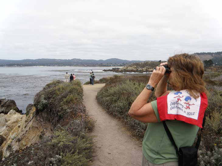
“Thar She Blows”. Thing Two has been looking for whales since The Cat in the Hat got a pair of Binoculars for Christmas for her. Every rock in the ocean looked like a whale to Thing 2. But today some of those rocks are going to be whales. We were driving down Highway 1 and a large number of people were looking at the ocean with cameras and binoculars. We went a little farther to Point Lobos State Reserve where the ranger told us that there were several whales to be seen. After lunch we started up the North Shore Trail. And there they were with their blow holes, fins and big bodies swimming in the cove. It was an unbelievable experience. It was the first time Thing Two, and Thing One, had seen a whale other than in an aquarium. There were a pod of at least five whales swimming in the cove. There blow holes were spouting water. There fins were coming up out of the water. Not only that but you could hear them. We even heard one of the whales do a belly flop-sounds like a muffled canon shot, even from ¾ of a mile away. Driving down the coast of California is always a great time but this day was even more wonderful for Thing One and Thing Two.


So much better than the whales in the Monterrey Bay Aquarium we submitted last year! And it also seems very appropriate that we would see these wonderful creates from Whalers Cove.


Adventure 051, Site 003 – Mission Carmel

Capture California, the Game-2012
Adventure: 051, Site 003 – Mission Carmel
California Landmark Number:135
National Registry ID: #NPS-66000214

Team: Thing One, Thing Two
Date:  August 31, 2012
Location:
Address: 3080 Rio Rd. Carmel-by-the-Sea, California


Description:
Date Built: June 3, 1770

See adventure Adventure 49/101, Mission 17 - Mission San Jose for further details.
NO. 135 MISSION SAN CARLOS BORROMÉO DE CARMELO - Mission San Carlos was established by Father Serra on June 3, 1770 at the Presidio of Monterey. Finding this location unsuitable, Serra moved the mission to Carmel Valley. In July 1771 he set to work constructing temporary buildings at the new site, and in December 1771 the mission was moved to its permanent location.
Location: SW corner of Lasuen Dr and Rio Rd, Carmel


References:


Overall Landmark References:

Adventure 49/101, Mission 19 - Mission Carmel

Capture California, the Game-2012
Adventure: 101 - 19: Mission San Carlos Borromeo de Carmelo, 2nd mission
Team: Thing One, Thing Two
Date:  August 31, 2012
Location: Carmel


Description:
In part because of needing to go to this mission, we decided to go down the coast from the Bay Area. So the first thing we did on this trip was to visit this mission. It just off of Highway 1, about ¾ of a mile from the highway. When we got there, the parking lot was pretty full, even though it was a Friday afternoon. You can tell it is a popular mission-what in Carmel is not popular?


Well, there is a price to be paid with popularity, and Thing One is inherently cheap. So we decided that we would just look around the place and admire the garden and exterior. So that is what we did. After 18 other missions, isn't one mission the same as another (the answer is no—each mission is different, Such as this mission is unique in that it has a covered bell tower.) So, on we went down the road.


From Wikipedia site:
It remains a parish church today. It is the only one of the California Missions to have its original bell tower dome. It was the site of the first Christian confirmation in Alta California In May, 1771, the viceroy approved Serra's petition to relocate the mission to its current location near the present-day town of Carmel-by-the-Sea.Serra's goal was to put some distance between the mission's neophytes and the Presidio of Monterey, (the headquarters of Pedro Fages, who served as military governor of Alta California between 1770 and 1774, with whom Serra was engaged in a heated power struggle). The original site continued to operate as the "Royal Presidio Chapel" and later became the Cathedral of San Carlos Borromeo. "Mission Carmel" (as it came to be known) was Serra's favorite and, being close to Monterey (the capital of Alta California), served as his headquarters. When he died on August 28, 1784, he was interred beneath the chapel floor.


As a result of Sir Harry Downie's dedicated efforts to restore the buildings, the Carmel mission church is one of the most authentically restored of all the mission churches in California. In 1987, Pope John Paul II visited the mission as part of his U.S. tour.


Several notable people are buried in the church and churchyard.


From California Missions Resource Center site:
Layout: An irregular shaped quadrangle. Only the ruins of the church remained standing when restoration began in 1921, so extensive excavation of the old foundation was required to determine the precise layout of the mission.
Mission Art: Mission Carmel is filled with significant art and original artifacts. One of the most notable attractions is a large wooden cross in the quadrangle, recreated on the site where fragments of the Cross erected by Fr. Serra were discovered during the mission restoration.
Special Attraction: One of the most popular attractions is the elaborate Serra Memorial Cenotaph (a monument not a tomb) sculpted in 1924 by Jo Mora. This is made of travertine marble and bronze and shows life-sized figures of Fr. Serra and three other pioneer missionaries, all of whom are buried under the church sanctuary.
Significant Event(s): In 1818 Hipolyte de Bouchard, an Argentine privateer, attacked and burned Monterey. The Carmel mission was evacuated but it was not harmed.
Interesting Facts: 
Carmel was headquarters of the mission chain from 1770-1803
The noted mission restorer, Sir Harry Downie (1903-1980), appointed the Carmel curator in 1932, guided the mission restoration for almost five decades, personally carving the reredos and pulpit of the church in 1956-57. Downie is buried in the mission cemetery.
Fr. Junipero Serra was selected to represent the state of California in Statuary Hall in Washington D.C. Sculptor Ettoro Cadorin's magnificent 7' fall statue of Fr. Serra, unveiled in 1939, pictures him holding a model of the Mission Carmel church.
The Carmel mission Orchard House of circa 1774 is the oldest residential dwelling in California.


From California State Parks site:
Founded by Father Serra in 1770 on Pentecost Sunday, this m ission was considered to be his favorite, and both he and Father Lasuen are buried here. It served as the ecclesiastical capital of California and also as Father Serra's headquarters for administrative duties as presidente of the missions. Set against the sea and mountains 115 miles south of San Francisco, this beautiful mission presents the complete quadrangle courtyard typical of mission architecture. The architecture is Moorish in design and the facade holds a star-shaped window directly above the main entrance. The gardens include culinary and medicinal herbs, citrus and olive trees, roses, Mexican sage and bougainvillea.
 3080 Rio Rd., Carmel, 93923, (831) 624-3600