Capture Calif

Capture California

What is a YOLT? Well, you may have heard the term YOLO. Gary and Sherri think we can live again, not as James Bond, but as being reborn. Consequently, we are having fun in our life, after all, You Only Live Twice.

Showing posts with label Wawona. Show all posts

Sunday, June 2, 2013

Adventure 011, Tagged Person 021, Carol W

Carol W and Sherri at Wawona Meadow
Capture California, the Game-2013
Adventure: 011, Tagged Person 021, Carol W
Team: YOLT
Date:  June 2, 2013
Location: Wawona Meadows
Description:
We know Carol W through our house church. She does like to hike, but does not have enough opportunity to. So she jumped at the chance to do a short hike with us. It is us which were blessed with her coming with us on Adventure 005, Hike 012 around Wawona Meadows.


Adventure 003, Site 004-Yosemite Transportation Company Office

Sherri and Gary at Yosemite Transportation Co.
Capture California, the Game-2013
Adventure: 003, Site 004-Yosemite Transportation Company Office

National Registry ID: 78000355

Team: YOLT
Date:  June 2, 2013
Location:
Address: Wawona

Description:
Date Built: 1910


The Yosemite Transportation Company Office, also known as the Wells Fargo Office, was built in the Yosemite Valley in 1910 to house facilities of motor stage and horse stage services between the nearest rail terminal at El Portal and Yosemite National Park. The rustic log structure also provided telegraph and express services.
The 1-1/2 story log structure measures 23 feet (7.0 m) by 21 feet (6.4 m), with a prominent front porch, accented by a decorative log truss. The building is an example of the National Park Service rustic style as it was applied at Yosemite, with strips of cedar bark applied in a decorative pattern. (Wikipedia)


References:


Overall Landmark References:

Adventure 003, Site 008-Wawona Hotel and Pavilion

Wawona Hotel and Sherri
Capture California, the Game-2013
Adventure: 003, Site 008-Wawona Hotel and Pavilion

National Registry ID: 75000223


Team: YOLT
Date:  June 2, 2013
Location:
Address: Wawona

Description:
Date Built: 1876
Architect: Washburn Brothers


The necessity to rebuild provided Washburn - who took over the management of the hotel after Washburn, Coffman and Chapman dissolved - and his new partner, Johnny Bruce, the opportunity to construct more substantial and modern hotel facilities. Within a week of the fire, they hired Joseph Shelly, builder of the Long White, and staked out a large two-story building that would include a lobby, sitting room, dining room, office and 25 guest rooms. Although accounts vary, it is believed the new hotel was ready and open for business in the summer of 1879.
Later that year, Big Tree Station welcomed distinguished guest, Ulysses S. Grant. Grant traveled 12 hours from Madera to Wawona by stage, where the Mariposa Brass Band greeted him with Hail To The Chief. According to the San Francisco Chronicle, so much road dust covered the General that he looked as if he had been engaged in the most hotly contested battle of the wilderness.
In 1882, Washburns wife suggested the Indian word, Wah-wo-nah - meaning Big Tree - as a more fitting name for the hotel complex than Big Tree Station. By Sept. 10, 1882, her name was official for the hotel and post-office, though it took a few years before local residents and guests acknowledged the change. (Hotel History)


References:
Overall Landmark References:

Adventure 003, Site 005-Jorgenson, Chris, Studio (Home)

Carol W and Sherri and Jorgenson House
Capture California, the Game-2013
Adventure: 003, Site 005-Jorgenson, Chris, Studio (Home)

National Registry ID: 79000280

Team: YOLT
Date:  June 3, 2013
Location:
Coordinates:
Address: Pioneer Yosemite Historic Center


Description:
Date Built: 1903
Architect: Chris Jorgensen


The era of the artist in Yosemite extends from 1855 to the present time. Artists were drawn to Yosemite, where they found inspiration in the magnificent scenery. Artist’ paintings, drawings, sketches, and photographs publicized and popularized Yosemite. They excited the curiosity of folks, and interest in the area grew rapidly. Consequently, many people chose to travel the rough route to Yosemite and experience the beauty firsthand.
Artist Chris Jorgensen, a noted painter, was one of many artists who popularized Yosemite and specialized in scenic paintings in oil and watercolor. Jorgensen first came to Yosemite Valley in 1898 and camped two summers before building his first cottage—a studio and residence—on the north bank of the Merced River in 1900. In 1903, he built a one-story, one-room log structure, “the bungalow,” on the opposite side of the river from the Sentinel Hotel in the Old Upper Village, and a short distance above the Sentinel Bridge. Jorgensen maintained a separate studio nearby, and also had a barn and storehouse. This new residence had a wood shingle-covered gable roof, with the front decorative gable end projecting ten feet beyond the front wall of the cabin. Its walls consisted of peeled logs in alternating tiers and contained an original stained glass window. Jorgensen maintained a seasonal residence and studio in the valley until 1918.
In 1917 the National Park Service was established. After a summer of inadequate tent quarters for a government mess, the operation moved into the old Jorgensen cabin, which the artist had vacated after relinquishing his concession. A committee of three men appointed by Superintendent W. B. Lewis made the studio into a clubhouse for members of the mess by converting it into a kitchen and dining room.
In 1921 the Yosemite Museum was established and housed in the old Jorgensen cabin. This was the first museum in a National Park. Chris Jorgensen donated his extensive Native American basket collection to the newly-established Yosemite Museum in 1923. (PYHCO)


References:


Overall Landmark References:

Adventure 003, Site 006-Hodgdon Homestead Cabin

Gary in front of the Hodgdon House
Capture California, the Game-2013
Adventure: 003, Site 006-Hodgdon Homestead Cabin
National Registry ID: 78000356

Team: YOLT
Date:  June 2, 2013
Location:
Address: Wawona

Description:
Date Built: 1879
Architect: Jeremiah Hodgdon


The Hodgdon Homestead Cabin was built by Jeremiah Hodgdon in 1879 in the Aspen Valley area of what became Yosemite National Park. The two story log cabin, measuring 22 feet (6.7 m) by 30 feet (9.1 m), was located in an inholding in the park, owned by Hodgdon's descendants. In the 1950s the family proposed to demolish the structure. The National Park Service acquired it and moved it to its Pioneer Yosemite History Center at Wawona, where the restored cabin is part of an exhibit on early settlement and development of the Yosemite area. In addition to housing Hodgdon, the cabin housed workers on the Great Sierra Wagon Road in the 1880s, as a patrol cabin for U.S. Army troops who managed the new national park in the 1890s, and as a historic landmark at the old Aspen Valley Resort.[2]
The cabin is built of peeled logs, saddle-notched, with split log wedge chinking. A shed addition to the rear gives the structure the shape of a saltbox and is a frame structure covered with wood shingles. The cabin is fronted by a porch. (Wikipedia)


The Hodgdon cabin represents the role of the homesteaders, a controversial chapter of Yosemite’s history. Homesteaders claimed a portion of the Yosemite area under the stipulations of the Homesteading Act of 1864. The Hodgdons owned a ranch in the Sierra foothills and claimed a section of land near Yosemite as summer pasture. The Hodgdons, along with other pioneer families, opposed John Muir’s efforts to create Yosemite National Park, believing that it would erode their rights as property owners. After building the only two-story cabin in the region, and creating a summer home, the Hodgdons feared that the creation of Yosemite National Park would undermine their homesteading efforts. (PHCO)


References:


Overall Landmark References:

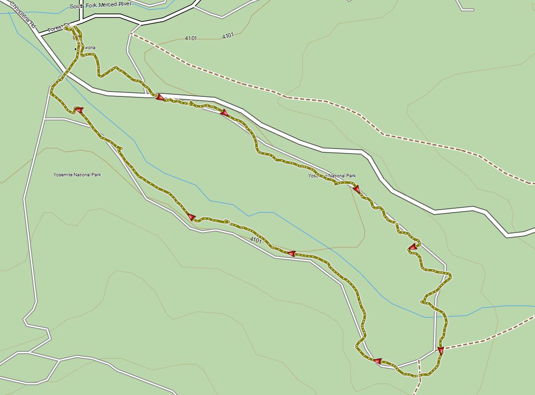
Adventure 005, Hike 012 – Wawona Meadow


Carol W and Sherri
Capture California, the Game-2013
Adventure: 005, Hike 012 – Wawona Meadow
Team: YOLT
Date:  June 2, 2013
Location: Wawona Meadow
Hike Info:
Trail: Wawona Meadow Loop Trail
Distance: 4.19 miles
Duration: 1.33 Moving
Elevation Rise: 391'


Description:
After church, our friend, Carol, and us went up to Wawona to meet our meetup group. It was a pretty warm day in Wawona, about 80 degrees-seemed a lot warmer. We got their before the meetup group could complete their Mirror Lake hike, so we took in the historical village at Wawona, and scored some Capture California points along the way—the old Acting Yosemite Superintendent's cabin, Hodgdon Homestead, Chris Jorgenson Art Studio, Wawona Hotel, and the Yosemite Transportation Company. Lunch of peanut butter and nutella was eaten by the Transportation Company's office and we enjoyed walking across the Old Wawona Covered Bridge. I visited my new park ranger friend, Heidi in the ranger station their—we were even able to score our wilderness permit for the Lyell Canyon four day backpack trip we went on Tuesday.
But still no Meetup group. So we went on a short walk up a ridge behind Wawona Lodge, when we got a text saying they were on the way. So down we went, waiting at the Wawona store—with some ice cold Snapple. Still no meetup group. So after an hour of waiting, we decide to go ahead on our hike around Wawona Meadow.
Wawona Golf Course
We have done Wawona Meadow walk before, actually several times. Since discovering this trail a couple of years ago, we have enjoyed the leisureliness of it, with the richness of plant and wild life experienced on it. On the other side of the experience, you have this nine-hole golf course, within the meadow, which sort of gives you a perspective of the diversity of use. At least that is probably better than the airport which which the meadow held in the 1930's. But maybe not quite as good as the apple orchard and vegetable gardens the Washburn's planted to supply their hotel guests.
On the way around the meadow, we see Annie and a friend returning from the meetup hike. We enjoyed seeing her—we had not seen her since a surgery she had a couple of months ago. From her, we hear that the meetup group is about a half an hour ahead of us
Wawona Meadow
As we hike to the southern part of the meadow the man-made elements fade into the background and you can enjoy the area. Our friend Carol is a gold mine of delightful knowledge of the biology of the Sierra's. Such as the male and female ferns we passed by—I for one, thought they were just different types of ferns. Our solitude remained until you hit the return trip and walk next to Highway 41.

Adventure 003, Site 007 - Acting Superintendent's Headquarters

Capture California, the Game-2013
Adventure: 003, Site 007 - Acting Superintendent's Headquarters
National Registry ID: 78000362


Team: YOLT
Date:  June 2, 2013
Location:
Address: Wawona

Description:
Date Built: 1904


The Superintendent's Office was originally erected by the Army at Camp A.E. Wood in 1904. It was moved to Yosemite Valley in 1906 and used as a residence until 1958, when it was moved back to Wawona to the History Center. This office, 15' x 12', is a l-1/2 story, board and batten structure, with a steeply pitched gable roof. The redwood roof shingles and board and batten siding are stained dark brown. The front facade features a simple porch, a four panel door, and a small 6-light window on the gable end. There are two casement windows on the north and south sides, each has 12 lights. (NRHP)


"Acting Superintendent" was the official title of the military commander stationed in Yosemite.


References:


Overall Landmark References:

Friday, May 31, 2013

Adventure 005, Hike 011 – Deer Camp Loop and Return to Car

Capture California, the Game-2013
Adventure: 005, Hike 011 – Deer Camp Loop and Return to Car
Team: YOLT
Date:  May 31, 2013
Location: Wawona, Yosemite
Hike Info:
Trail: Deer Camp Loop (different hike) and Return trip to Car (repeat of May 30th)
Distance: 11.34 miles
Duration: 4:59Moving
Elevation Rise: 1,302'


Description:
This area of Yosemite is pleasant, not spectacular. So we did not take pictures of noteworthy importance—you can tell that from the lack of pictures on our blog. Even so, Sherri and I enjoyed our 11+ mile day.

Adventure 009, Bridge 006 – The New Wawona Bridge

Capture California, the Game-2013
Adventure: 009, Bridge 006 – The New Wawona Bridge
Team: YOLT
Date:  May 31, 2013
Location: Wawona
Description:
The day is getting old, the body is tired and the heat feels unbearable. But low and behold, a bridge comes before us! It is the new Wawona bridge across the South Fork of the Merced River. This newly erected bridge, at least new by the Wawona Covered Bridge standards, provides the entrance way into Southern Yosemite for those coming up Highway 41, also known as the Wawona Road, north of Fresno. There is a pedestrian walkway on the eastern side of the road. With the river flowing beneath you, even the sun is bearable.


Like was said earlier, this is the new Wawona Bridge. The National Park Service replaced the older bridge a few years ago. The original bridge was constructed in 1931, then destroyed in a flood and rebuilt in 1938. This bridge was deemed critically deficient in 1992. After a series of court issues, it was replaced in the late 2000's. For more information, see the NPS site.


Adventure 009, Bridge 005 – Wawona Covered Bridge

Gary Entering the Wawona Covered Bridge
Capture California, the Game-2013
Adventure: 009, Bridge 005 – Wawona Covered Bridge
Team: YOLT
Date:  May 31, 2013
Location: Wawona, Pioneer Yosemite History Center
Description:
Coming back from a backpack trip, we stopped in Wawona for a few minutes. We then remembered the two bridges in Wawona. The first is the main bridge which is in use, which guides traffic along Highway 41. But the truly “stop-and-look-at” bridge is the old Wawona Covered Bridge. It is part of the Pioneer Yosemite History Center. Occasionally a horse drawn wagon will still cross this bridge, but none today. We were the only ones here, except for one lady. It gives you time to hear the river running under the bridge, the waters reverberating amongst the rafters.

Adventure: 003, Site 003-Wawona Covered Bridge

Gary entering the covered bridge at Wawona
Capture California, the Game-2013
Adventure: 003, Site 003-Wawona Covered Bridge

National Registry ID: 6001261

Team: YOLT
Date:  May 31, 2013
Location:
Coordinates: 37°32'18" N, 119°39'34" W
Address: Wawona

Description:
Date Built: 1857
Architect: Galen Clark

Coming back from a backpack trip, we stopped in Wawona for a few minutes. We then remembered the two bridges in Wawona. The first is the main bridge which is in use, which guides traffic along Highway 41. But the truly “stop-and-look-at” bridge is the old Wawona Covered Bridge. It is part of the Pioneer Yosemite History Center. Occasionally a horse drawn wagon will still cross this bridge, but none today. We were the only ones here, except for one lady. It gives you time to hear the river running under the bridge, the sound of the waters reverberating amongst the rafters.


All Yosemite-bound traffic through here crossed the bridge. The deck and truss portion of this bridge across the South Fork of the Merced River was built around 1857 by settler Galen Clark, who established a tourist facility here. The area was then called Clark’s Station. Clark’s role as one of the original conservationists and innkeepers places him in one of the earliest chapters of Yosemite’s history. After Abraham Lincoln signed legislation in 1864 protecting Yosemite Valley and the Mariposa Grove of Giant Sequoias by creating the Yosemite Grant, Clark was appointed the Guardian of the Grant.
The road from Wawona to the Yosemite Valley opened in 1875 just after the Washburn brothers purchased Clark’s land along the river. The brothers, who were from Vermont, covered the bridge in 1879. Although the large beams were hand-hewn with ax and saws, the lumber to cover the bridge was cut locally at the Washburn’s sawmill. Specialty axes were used to hew round logs into square timbers and mortise and tenon joints were used to join the timbers. Bridges were covered primarily to protect the large wood truss beams and flooring from the weather. It is much easier to re-shingle a roof than to replace the major supporting structures. The covering also helped horses stay focused on the road rather than the sometimes raging river in spring. Did the Washburn brothers cover the bridge exclusively for practical reasons? Maybe so. But a granddaughter claims the reason was nostalgia — they were homesick for a bit of New England.


The bridge was used until 1931 when the Wawona Road was rerouted west to a modern concrete bridge (which, in turn, has been replaced after damage from the 1997 floods). A flood in 1955 nearly destroyed the covered bridge. Its 1957 restoration was the first step in the creation of the Pioneer Yosemite History Center. Glenn Gordo, master craftsman and builder from Mariposa and grandson of a pioneering Portuguese couple, along with his crew, were recruited after the flood to restore the bridge. (PYHCOT)


References:


Overall Landmark References:

Thursday, May 30, 2013

Adventure 005, Hike 010 – Alder Creek

Capture California, the Game-2013
Adventure: 005, Hike 010 – Alder Creek
Team: YOLT
Date:  May 30, 2013
Location: Wawona, Yosemite
Hike Info:
Trail: Alder Creek
Distance: 8.19 miles
Duration: 4:09 Moving
Elevation Rise: 2,163'


Description:
One of our favorite early season hikes. The falls on Alder Creek are first rate, even though this year, they are not as full as they usually are. Nice afternoon hike. See our blog for more info.

Sunday, September 9, 2012

Adventure 008, Hike 104 - Wawona Meadow Loop

Capture California, the Game-2012
Adventure: 008, Hike 104 – Wawona Meadow Loop
Team: Thing One, Thing Two
Date:  September 9, 2012
Location: Wawona, Yosemite
Hike Info:
Trail: Wawona Meadow Loop
Distance: 4.2 miles
Duration: 1:37
Elevation Rise: 269'


Description:

Last year we did this trail counter-clockwise. So this year we thought we would do it clockwise. This means starting at the general parking lot. We then travel up to the Wawona Hotel, where Thing One discovers he forgot the camera. So back to the car he goes. But not for long as he catches up with Thing Two and our son Steven just after crossing the highway. Then it is on to a pleasant walk around the perimeter of the meadow. The southern end of the meadow the park service has been restoring back to its earlier drainage patterns. Even with the restoration project, a lot of the meadow does look dry. But it has also been a very low rainfall year. As we have circled back on the west side of the meadow, we come to the northern half of the meadow, which has been turned into a golf course, back in 1918. On the golf course, we see a deer and her fawn feeding. As we finish out the walk, we decide that we have had enough for today and it is down to Todd's Cookhouse in Oakhurst for some of the BBQ food in California.


Item: 8 - Wawona Meadow Loop Trail
Team: Tired 'Tirees
Date:  Oct 4, 2011
Link:

Desc: The Wawona Meadow Loop is a nice, gentle trail which goes round Wawona Meadow. We went 4.2 miles in about an hour and a half period of time. You start by cutting through a golf course. Did I say golf course? In Yosemite National Park? Yep that's right. This course has been there over 90 years. Before that it was farmland used to feed the clients of the Wawona hotel. There are still apple trees from this time. Before this, it was a meadow, like what we walked around.

Once you make it to the other side, you follow a road around the meadow. While we were there, the Park Service was working on a meadow restoration project. They are trying to get the flow of water and the grasses to take on a more "natural" course. As you cross the current highway--the road we are on is the original road--you come to the old Wawona hotel and back to your car.

Adventure 008, Hike 103 - Fish Camp Falls Trail

Capture California, the Game-2012
Adventure: 008, Hike 103 – Fish Camp Falls Trail
Team: Thing One, Thing Two
Date:  September 9, 2012
Location: Big Sandy Road outside of Fish Camp
Hike Info:
Trail: Fish Camp Falls Trail
Distance: 1.8 miles
Duration: 0:58
Elevation Rise: 374'


Description:
We found this hike last year while hunting for California falls for Capture California. Sometimes a repeat hike is just so ho-hum, but not this time. Last year we could see only the lower falls because there was enough water coming down, it would have made it hard crossing Big Creek. This year, with the drought and all, and it being late summer, it was a dry crossing. So we saw the lower, middle and upper falls, and as Ann Marie Brown says in her book, California Waterfalls, the last one is the most photographed, and well it should be. I am with her that if it was not for Yosemite, this set of falls would have its own park.

Lower Fish Camp Falls


We hiked up to the upper falls, just short of a mile. The first 2/3 of a mile is pretty much level. After we cross Big Creek, the trail becomes more of a minor scramble, but nothing serious. We meet a fisherman teaching his kids how to fish returning from his trip. Once up at the upper falls, we gawk for awhile and return.


Middle Fish Camp Falls
For last year's adventure, see the following write up:


Item: 8 - Fish Camp Falls Trail
Team: Tired 'Tirees
Date:  Oct 2, 2011
Link:
Desc: See the description of the Fish Camp Falls for how to get here. This trail starts off with the question, am I at the right place. After checking out the guidebook, we figure this must be the place--2.5 miles from Hwy 41, gate, pull out, small creek or flume with a building. Yep all checks out. So we go around the gate, past the building and then along this level trail, built just above this creek. As we walk, we see where the water is going away from the creek back towards the building. But the trail itself is very level. This small creek we are following is really a flume and the trail we are walking is really the bank of the flume. I suspect the building we passed several iterations ago must have been a saw mill.
So after .6 miles along this, a broad-leaf greenery and tree protected  path, we come to the falls. You return back the same way for a total of 1.2 miles. This will be a path we do in the future.
Upper Fish Camp Falls


Item: 81 - Fish Camp Falls (Falls #24)
Team: Tired 'Tirees
Date:  Oct 2, 2011
Link: 
The Falls
Desc: Sometimes there is something in your own backyard which you do not see before. Sherri and I were looking at a book called California Waterfalls by Ann Marie Brown, when we saw that there is set of falls which we have been passing within 3 miles of and knew nothing about. This is Fish Camp Falls. Coming out of Fresno, you travel up Hwy 41 until right before the the Tenaya Lodge in Fish Camp--this is two miles before the southern entrance to Yosemite. You take Sandy Marsh Road about 2.5 miles and stop--see the trail description here. After walking up a nice trail, you stop at the lower set of falls, which drop about 25 feet. It provides a nice backdrop and a place to have a picnic lunch. There are other falls up the creek a bit which we will explore another day.


Wednesday, May 9, 2012

Adventure 019 - Snowy, the Snowman


Adventure: 019 – Snowy, the Snowman
Team: Thing One, Thing Two
Date:  May 9, 2012
Location: A little creek, Wawona, Yosemite

Description:
Snowy, the snowman is a bit small. But we will not be too prejudiced against those with altitude deficiencies, will we? We found Snowy, just laying around in the, well snow on our Deer Camp hike.
So with the help of our son, Steven, we built Snowy into the snowman he is today. Now he can stand tall, figuratively, in the world of snowmen. We can honestly say that he is the tallest snowman which there will be this season within five miles of him. For such a little fellow, this is saying something big.

Adventure 030 - Under the Stars


Adventure: 030
Team: Thing One, Thing Two
Date:  May 8, 2012
Location: Alder Creek Crossing, Wawona, Yosemite

Description:
Sleeping under the stars. Such a delight. This night was even better than normal. The air was clear, the sky was black, and we were together—after all, it was getting a bit cold. As the sun set, the stars started coming out, displaying the glory of their maker. The sight was so wonderful, each time we woke up in the middle of the night, we would gaze at them. Then to crown it all off, an almost full moon makes it appearance, drowning out the stars, flooding the skies with its radiance.


The next morning when we awoke, we found we paid a small price for the enjoyment of the skies. Our sleeping bags had been wetted with the dew of the morning. Our backpacks had seen frost.


Adventure 008, Hike 003 - Deer Camp, Almost


Adventure: 008, Hike 003
Team: Thing One, Thing Two
Date:  May 9, 2012
Location:  Deer Camp, Wawona, Yosemite


Hike Info:
Trail: Adler Creek to Deer Camp--almost
Distance: 3.0 miles
Duration: 1:40
Elevation Rise: 770'
Description:
We take off going up the side of Alder Creek—while the water was down a little, it still looked cold. None of us wanted in. So up the east side of the creek and cross-country for about a third of a mile, till we hit the trail. Lots of brush, lots of downed trees. But after awhile we meet up with the trail to Deer Camp.

It is a lot easier on the trail than the cross-country route we were taking. Even though there was a place where the trail fooled us. It did a switch back, but looked like it was going to go straight. So we took 10 minutes figuring this out and back-tracking to find the trail.

It is onward and upward. The trail goes long the side of the ridges, following the creek. We get to a small creek crossing. This is where Sherri and I could not cross several years ago—then there was lots of snow. But now, it is obvious how to cross it. We wonder what stopped us before—except for the snow.

We go another quarter of a mile and come to a little bigger crossing-still very crossable. But we have reached our check point time. So it is time to turn back. Wonder when we will be able to see this place, after all it is our fourth attempt. This time we are pretty near. None of the reasons to turn back was technical nor endurance, just we have to contend with other priorities.

The trip back to our camp is not very exciting. We did stop to build a snow man—a small one. Still it is a legit snow man. Sherri also gets a lesson in GPS usage.


Tuesday, May 8, 2012

Adventure 008, Hike 002 - Wawona to Alder Creek


 Adventure: 88, Hike 002
Team: Thing One, Thing Two
Date:  May 8, 2012
Location: Wawona, Yosmite
Hike Info:
Trail: Wawona to Alder Creek
Distance: 8 miles
Duration: 4:20
Elevation Rise: 2,568


Description:
We make it to the trail head at Wawona around 9:40. Then hit the road a half an hour later. Much better than the last time we were up here.

Same trail, same sun on us. We go a third of mile when Sherri discovers she left her GPS on the hood of the car. Steven goes back to get it. Sherri and I continue on.

Dry heat with little breezes at time to cool us off. When we left the car, it was 70 degrees. At 11, after going 1.2 miles and 700' up, we stop for an elevense's break. After a few minutes, Steven catches up with us.

More uphill. I write a little while longer as Steven and Sherri continue on. I plod after them for about half an hour before catching up with them. We past the fallen log where we lost the GPS last time. At 12:15, we have our lunch, 2.8 miles into the trail-just a tenth of a mile from the Mosquito Creek trail junction. Usual fare of Ritz crackers, Peanut Butter and Nutella. We debate on how healthy can this be? My thinking, who cares? It tastes so good and we are doing so much work, it cannot be too bad.

While reading and resting, we saw a hawk gliding overhead, riding the warm air currents. It looks so graceful as he swoops and pivots and swoops again, free from visible effort. But we get no picture for Capture California.

1pm—we leave our lunch spot and start in. Shortly we come to the trail junction. After this it is a series of rolling hills, gradually going up. We pass our campsite from three weeks ago—completely free of snow. Three Falls is still flowing. After a spurt of up hill, we top out on the old railroad grade. From here, the trail is flat. You see remnants of old railroad ties. We stop at our creek to refill water bottles and take a break.

Then comes the highlight of the trip—Alder Falls. If Alder Falls was along a road or in the Valley, it would compete with Vernal and Nevada Falls. But you need to hike in 5 miles, climb 2,000' to enjoy this view—I like it that way. The effort makes the enjoyment that much better.

We look and gawk at the Falls. Then continue on, up Alder Creek. Then the railroad leaves us above the Falls. The trail is more single file. But gentle. We get to the creek crossing for Alder Creek. The snow runoff is going strong still. So we ponder our options. In the end, we decide to stop before crossing. We have gone 7 miles, with a gain of 2200' in four hours walking. Not bad. Of course, my brother would not let this stop him. (Later in talking with him, he thought that we were there to enjoy, not to show courage.) We have crossed this creek before, just as wet, just as wide. But it is just as cold now as then. I am getting more cautious in my old age.