Capture Calif

Capture California

What is a YOLT? Well, you may have heard the term YOLO. Gary and Sherri think we can live again, not as James Bond, but as being reborn. Consequently, we are having fun in our life, after all, You Only Live Twice.

Showing posts with label Pasadena. Show all posts

Saturday, October 6, 2012

Adventure 051, Site 154 – Old Mill


Capture California, the Game-2012
Adventure: 051, Site 154 – Old Mill
California Landmark Number: 302
National Registry ID: 1971000154


Team: Thing One, Thing Two
Date:  October 6, 2012
Location:
Latitude: N 34° 07.112
Longitude: W 118° 07.661
Address: 1120 Old Mill Rd, San Marino

Description:
Date Built: 1823
Architect: Father José María Zalvidea


In a very nice part of San Marino—everything which I have seen in San Marino is nice—we find the the landmark sign for the Old Mill. It is now the California Art Club. We walk up the driveway, as there is a sign saying limited parking and no turn around. The Old Mill is behind an adobe wall with a locked gate. The Art Museum does not open for another three hours. So we have to be content with the shade of some broadleaf trees and looking over the wall before retreating back to the car.

NO. 302 OLD MILL - The Old Mill, El Molino Viejo, was designed by Father José María Zalvidea and built of fired bricks and adobe about 1816 to serve Mission San Gabriel. Another grist mill was built in 1823 near the mission and the old mill was gradually abandoned - it passed from mission control in 1846. The property remained in private hands until 1903, when Henry E. Huntington bought the building and used it for a golf clubhouse. Later owners, Mr. and Mrs. James Brehm, had the mill restored in 1928 by Frederick Rupple.
Location: 1120 Old Mill Rd, San Marino


From the NRHP:
In designing the mill, Father Zalvidea pioneered the use a horizontals direct impulse waterwheel. Built by Mission Indians under the supervision of the Majordomo, the mill was finished about l8l6 in the Spanish tradition. Cement and lime were locally made. The thick lower walls and foundations are. of quarried volcanic stones arid are strengthened by corner buttresses. The upper walls,3' thick, and the arched water chambers are of fired, hand -made adobe brick. The tile roof is supported by a wood frame structure.


References:


Overall Landmark References:

Adventure 051, Site 153 – Governor Stoneman Adobe

Capture California, the Game-2012
Adventure: 051, Site 153 – Governor Stoneman Adobe
California Landmark Number: 669


Team: Thing One, Thing Two
Date:  October 6, 2012
Location:
Latitude: N 34° 06.875
Longitude: W 118° 08.193
Address: 1912 Montrobles Place , San Marino, CA

Description:


Thing One is not sure how he would feel about having a plaque in his front yard, along with a remnant of a adobe wall. But that is where we found this landmark, in a residential area. So it is a stop and take a picture and be off, rather than snooping into someone's front year.


Stoneman was both a general in the Union army during the Civil War. He later on served as Governor of California for a single term as a Democrat, from 1882-1886. If you remember the Robbie Robertson song, The Night They Drove Ole Dixie Down, Stoneman is mentioned in there:


Virgil Caine is the name, and I served on the Danville train,
Till Stoneman's cavalry came and tore up the tracks again ..


NO. 669 GOVERNOR STONEMAN ADOBE, LOS ROBLES - This was the site of 'Los Robles,' the 400-acre estate of Governor George Stoneman. President Rutherford B. Hayes was entertained here in 1880. The first schoolhouse in the San Gabriel Valley, California's first tennis club, and the first municipal Christmas tree of San Marino were located here.
Location: 1912 Montrobles Place, San Marino


From Waymarking:
This was the site of 'Los Robles,' the 400-acre estate of Governor George Stoneman. President Rutherford B. Hayes was entertained here in 1880. The first schoolhouse in the San Gabriel Valley, California's first tennis club, and the first municipal Christmas tree of San Marino were located here.


References:


Overall Landmark References:

Adventure 051, Site 152- Gamble House


Capture California, the Game-2012
Adventure: 051, Site 152- Gamble House
California Landmark Number: 871
National Registry ID: 1971000155


Team: Thing One, Thing Two
Date:  October 6, 2012
Location:
Latitude: 34° 9.102′ N
Longitude: 118° 9.648′ W
Address: 4 Westmoreland Place, Pasadena, CA

Description:
Date Built: 1908
Architect: Charles Sumner Greene and Henry Mather Greene

If we had only looked at some of the photo's before going to the house, we would have saved ourself a lot of time wandering. But then again, when has team Thing One, Thing Two ever been adversed to wandering? We went to the house looking for its plaque. After due examination, Thing Two started a walk around the house, while Thing One having seen some plaques down the street turned to investigate those. But both of those searches were in error. The plaque was right there by the house all of the time. This time, the plaque sunk in the grass by the sidewalk in front of the house.

The house itself is wood-sided and stands out. It is part of USC and is a show case of fine architecture. By the way, the David and Mary Gamble whose house this was? This is the same Gambles as in the company, Proctor and Gamble.


NO. 871 THE GAMBLE HOUSE - Built in 1908, the David B. Gamble House is a tribute to the genius of architects Charles Sumner Greene and Henry Mather Greene. Its design represents a unique California lifestyle and is a masterpiece of American craftsmanship. In 1966 it was made a gift by the Gamble family to the City of Pasadena in a joint agreement with the University of Southern California.
Location: 4 Westmoreland Place, Pasadena


References:


Overall Landmark References:

Adventure 051, Site 151 – First Trust Building


Capture California, the Game-2012
Adventure: 051, Site 151 – First Trust Building
National Registry ID: 1987000941
Team: Thing One, Thing Two
Date:  October 6, 2012
Location:
Latitude:34°8′46″N
Longitude: 118°8′13″W
Address: 587-611 East Colorado Boulevard and 30-44 North Madison Avenue, Pasadena, CA

Description:
Date Built: 1927
Architect: Cyril Bennett and Fitch Haskell
Architectural Style: Renaissance Revival, Mediterranean Revival, Late 19th And 20th Century Revivals
Date added to NRHP: June 12, 1987
When we were walking around Old Pasadena, we saw this building. It had a plaque, but a pretty modern day plaque and nothing which said it was historical. But the building itself called attention to itself. From the tall cupola with its steel and glass, down to the street-level exterior, it just called to us. The building is meant to call out to people. Later on we wandered past the same intersection and saw that it was on the National Registry of Historical Places-still no plaque, but at least the right address. Currently it houses the Bank of the West.


References:


Overall Landmark References:


Adventure 051, Site 149 – Pasadena Playouse


Capture California, the Game-2012
Adventure: 051, Site 149 – Pasadena Playouse
California Landmark Number: 887
National Registry ID: 1975000435


Team: Thing One, Thing Two
Date:  October 6, 2012
Location:
Latitude: N 34° 08.709
Longitude: W 118° 08.230
Address: 39 South El Molino Avenue, Pasadena, CA

Description:
Date Built: 1924
Architect: Elmer Grey


On this Saturday morning, Thing One and Thing Two strolled around Pasadena to see the sights. One of the destinations was the Pasadena Playhouse. The building itself blends in with the other buildings along the El Molino. Sort of a non-descript plaster building. When we got there, a couple actresses where waiting for the building to open. We climbed the short set of stairs and found our plaque and went off for more adventure.


The playhouse is considered Elmer Grey's outstanding design. Each year it produces an outstanding set of productions and has produced many of the worlds theater stars.


NO. 887 PASADENA PLAYHOUSE - Founded in 1917 by Gilmor Brown, the Pasadena Playhouse was designed by architect Elmer Grey and the cornerstone laid May 31, 1924. In 1928 the College of Theatre Arts was incorporated with the Pasadena Playhouse Association as a non-profit institution. In 1937, the Playhouse received the honorary title 'State Theatre of California' from the California Legislature.
Location: 39 El Molino Ave, Pasadena


References:


Overall Landmark References:

Adventure 051, Site 150 – Pacific Asia Museum


Capture California, the Game-2012
Adventure: 051, Site 150 – Pacific Asia Museum
California Landmark Number: 988


Team: Thing One, Thing Two
Date:  October 6, 2012
Location:
Latitude: 34° 8.805′ N
Longitude: 118° 8.461′ W
Address: 46 North Los Robles Ave, Pasadena CA

Description:
Date Built: 1929

In looking at some web pictures of the building, we did not get enough perspective on it. We were able to park pretty close to the building. The front of the building looked very much like any other building. There was a couple of plaster-cast statues in front, but nothing terribly exciting. Even the mural on the side of the building looked typical LA style. What we missed was to walk across the El Molino and observe the front from a distance, to see the upper-story decorations.


NO. 988 PACIFIC ASIA MUSEUM (GRACE NICHOLSON'S TREASURE HOUSE OF ORIENTAL AND WESTERN ART) - Grace Nicholson, a noted collector and authority on American Indian and Asian Art and artifacts, supervised the design of her combination gallery and museum which was completed in 1929. It has been called an outstanding example of 1920s revival architecture and is unique for its use of Chinese ornamentation.
Location: 46 North Los Robles Ave, Pasadena


References:


Overall Landmark References:

Adventure 051, Site 148 - Singer Building


Capture California, the Game-2012
Adventure: 051, Site 148 - Singer Building Pasadena
National Registry ID: 85001066[1]

Team: Thing One, Thing Two
Date:  October 6, 2012
Location:
Latitude: 34°8′44″N
Longitude: 18°8′20″W
Address: 16 S. Oakland Ave. and 520 E. Colorado Blvd., Pasadena, California

Description:
Date Built: 1926
Architectal style: Spanish Colonial Revival
Added to NRHP May 16, 1985

We came across this building when we were walking between two California Historical Buildings . It is always great to come across the unexpected and discover a bit more of California History.


From NRHP:
The Singer Building is architecturally significant as "a good, as yet unspoiled example of Spanish Colonial Revival commercial work. Its style, quality, scale, and location capture the essence of the historic character of Pasadena's symbolic and actual main street, Colorado Boulevard, during its heyday in the 1920s.


References:


Overall Landmark References:

Friday, October 5, 2012

Adventure 051, Site 147 – Baldwin Queen Anne House

Capture California, the Game-2012
Adventure: 051, Site 147 – Baldwin Queen Anne House
California Landmark Number: 367
National Registry ID: 1980000804


Team: Thing One, Thing Two
Date:  October 5, 2012
Location:
Latitude: N 34° 08.479
Longitude: W 118° 03.230
Address: Los Angeles State and County Arboretum, 301 N Baldwin, Arcadia

Description:
Date Built: 1881
Architect: A.A Bennett-the same architect which designed the State Capital and the Merced Courthouse, and father-in-law to EJ Baldwin


This house is just a matter of a hundred feet from the Reid Adobe. It has an appears of a fairy tale house amongst all of the greenery surrounding it. We walked around the house, well until we came to a taped off section due to bees. But the house was closed when we were there. This would be a good backdrop for a celebration. Think of having all of the Arboretium as a place to stroll.


After reading some of the information concerning the house, it is right. Even thought the house was made as a guesthouse, it reminded Thing One more of a gazebo or recreational house than a place for someone to live.


NO. 367 E. J. BALDWIN'S QUEEN ANNE COTTAGE - Designed by A. A. Bennett for entertaining, the cottage was constructed by Elias Jackson ('Lucky') Baldwin in 1881. Since there was no kitchen, meals were served from the nearby adobe (built by Hugo Reid in 1839) where Baldwin actually lived. The building was restored and dedicated May 18,1954 as part of Los Angeles State and County Arboretum.
Location: Los Angeles State and County Arboretum, 301 N Baldwin, Arcadia


From NRHP:
Though it is actually of Stick-Eastlake design, Elias Jackson ("Lucky") Baldwin's guesthouse (1885) is commonly referred to as the "Queen Anne Cottage". In reality, only the octagonal configuration of the tower hints at the Queen Anne, a style in which the use of polygonal towers and assorted large bays and gables often defined the volumes of the building. The idea of the tower itself in American architecture can be traced back to the Italian Villa mode of the 1840's in which a picturesque silhouette for buildings was important, and in which the idea of the Italian belvedere from which to view the countryside became popular.


The character of the building as a folly is emphasized by its relative isolation in an exotic landscape ensemble which includes a natural lake, specimen trees, cultivated lawns, and wild undergrowth. The lake remains much as Baldwin landscaped it in the late 1880 T s, though there has been a loss of a number of the decorative granite boulders which once rimmed the perimeter. … A grove of Mexican fan palms planted by Baldwin, now among the tallest in the continental United States, tower over the Cottage grounds; willows still grace the lake shore; a 160 foot tall blue gum Eucalyptus shelters the Cottage walkway; a magnificent English Oak planted by Baldwin in 1876 still shades the lawn between the Cottage and the Barn; and descendants of Baldwin planted black walnuts, gingkoes, cypress, elms, and persimmons lend variety to the landscape.


Elias Jackson ("Lucky") Baldwin, a San Francisco businessman who had made millions in Comstock dealings, used $200,000 of his fortune to purchase the 8,500 acre Rancho Santa Anita in 1875. A loan foreclosure on the Temple and Workman Bank (Temple and Workman lands were held as collateral) plus additional land purchases increased his Southern California holdings to nearly 50,000 acres within a year and made Lucky Baldwin a landowner of acknowledged importance in the Southland.


References:


Overall Landmark References:

Adventure 051, Site 146 – Reid Adobe

Capture California, the Game-2012
Adventure: 051, Site 146 – Reid Adobe
California Landmark Number: 368


Team: Thing One, Thing Two
Date:  October 5, 2012
Location:
Address: 301 North Baldwin in Los Angeles Arboretum

Description:
Date Built: 1839


The Reid Adobe is within the Los Angeles County Arboretum. We had just done our hike with our daughter up Santa Anita Canyon when the Arboretum was before us. We decided that it would be nice to wander through here and discover what was inside. Our youngest daughter lives in Los Angeles and had not been here. What we found was an oasis within the urban desert. By a pond, we saw the Reid Adobe., which probably is not the correct location, but it is a representation of the building.


The Reid Adobe was used as a living quarters by EJ Baldwin while he built his house. Then later on when Baldwin built his house, it was used to cook the meals. The Baldwin house did not have any cooking facilities.


NO. 368 HUGO REID ADOBE - Hugo Reid, a Scotsman, petitioned the government of Mexico to grant him Rancho Santa Anita. His claim strengthened by his marriage to Victoria, a native Indian of the San Gabriel Mission, he received the grant on April 16, 1841. Immediately upon filing his petition, Reid took possession of the land, started to farm and plant vineyards, and built the first house-the Hugo Reid Adobe-in 1839. In 1875, E. J. Baldwin purchased the rancho and in 1879 added a wooden wing to the old adobe.
Location: Los Angeles State and County Arboretum, 301 N Baldwin Ave, Arcadia


From the LA Arboretum Historical Site:
Don Perfecto Hugo Reid (1810-1852), a Scottish adventurer and naturalized Mexican citizen, was the first private owner of the 13,319 acre Rancho Santa Anita. The adobe was constructed in 1840 with the help of Gabrielino laborers. It was built of sun-dried adobe blocks made by mixing clay soil, water and a straw binder. The roof was made of rawhide-lashed carrizo cane (Arundo donax). As protection from the elements, the roof was smeared with brea (tar) and the walls were white-washed.


References:


Overall Landmark References:

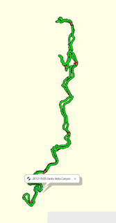
Adventure: 008, Hike 130 - Gabrielino Trail

Capture California, the Game-2012
Adventure: 008, Hike 130 - Gabrielino Trail
Team: Thing One, Thing Two
Date:  October 5, 2012
Location: Arcadia, CA
Hike Info:
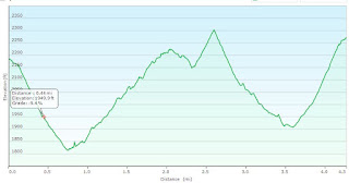
Trail: Gabrielino Trail to Sturtevant Falls
Distance: 4.3 miles
Duration: 2:42
Elevation Rise: 971'


Description:
Thing One and Thing Two went down to Southern California to celebrate their youngest daughter’s birthday. She took her Mom and Dad on a trail in the Big Santa Anita Canyon. After a short drive from Pasadena we came to the trailhead. We had to pay an Adventure Pass fee to park and then we were on our way. It was a very interesting trail with yucca plants then within a few steps, we saw pine trees. It reminded us of going from dessert to mountains. From 1912 to 1936 this area had lodging and rental cabins. There are now quite few private rustic cabins. Sometimes along a trail you will see a great sign. This one said: Take Care of the Land, Someday Youl'l Be Part of It. Then, as if to put an emphasis on it, we saw a dead owl in the middle of the trail.


Earlier in the season we would have seen number of waterfalls as well as wildflowers. We did hike to Sturtevant Falls and enjoyed lunch together. We returned on the same trail except for one minor detour when we took the horse trail to try to make it a loop. From many points along the trail you could see up or down the canyon and get some pretty good views. This minor detail afforded us some of the best views from this trail. Also on the way out, we got into a conversation with John, who owns one of the cabins in the canyon. He talked a bit about having to repair a door which a bear had gotten in through. It sounded like he was taking it as a matter of fact, even though this was not the first time a bear had gotten into the cabin.


This was a good hike. But what ever trail you are on, it is great to hike with your family. And today it was wonderful being lead by our youngest daughter.


Trail listed in California Waterfalls by Ann Marie Brown-“Gabrielino Trail meanders under the shade of oaks and alders along Big Santa Anita Creek. The stream is tamed somewhat by a series of small check dams, forming oddly pretty artificial waterfalls and glassy pools.” Page 434


Thursday, October 4, 2012

Adventure 051, Site 141 – Christmas Tree Lane

Capture California, the Game-2012
Adventure: 051, Site 141 – Christmas Tree Lane
California Landmark Number: 990
National Historical Number: 1990001444

Team: Thing One, Thing Two
Date:  October 4, 2012
Location:
Latitude: 34° 11.042′ N
Longitude: 118° 8.324′ W
Address: 2230-2282 Santa Rosa Avenue, Altadena CA 91001


Description:
Frederick C Nash in 1920 created this Christmas Tree Lane from the 135 Deodar trees planted along Santa Rosa Ave. Since that time, a mile of lights has been a holiday tradition of Altadena.


We have a Christmas tree lane in Fresno so when we saw the sign for Christmas tree lane in Altadena, Thing 1 and Thing 2 could not pass it up. This Christmas tree lane is planted the same type of tree that is planted on our street in Fresno.

As a note, Fresno has a Christmas Tree Lane, going down our Van Ness Ave, which has been going on since 1912. The Lane is about 2 miles long. Twice during the season, the avenue is closed off to traffic and walkers have a night of it. Both Thing One and Thing Two enjoy the time walking this.


NO. 990 CHRISTMAS TREE LANE - The 135 Deodar Cedar trees were planted in 1885 by the Woodbury Family, the founders of Altadena. First organized by F.C. Nash in 1920, the 'Mile of Christmas Trees' has been strung with 10,000 lights each holiday season through the efforts of volunteers and the Christmas Tree Lane Association. It is the oldest large-scale Christmas lighting spectacle in Southern California.
Location: Santa Rosa Ave, both sides of street from Woodbury Ave to Altadena Dr, Altadena


From NRHP:
Christmas Tree Lane is significant as the most prominently recognized landscape feature in Altadena. The six block double row of one hundred year old Deodar Cedar trees have been an important part of the history of the community since first being planted in 1885 by Altadena 1 s founders, Frederick J. and John P. Woodbury, as part of their ranch. The trees have attained significance because of their association with an important community event. A Christmas Tree lighting ceremony was started in 1920 as a community project and has become a major event for Altadena and the surrounding San Gabriel Valley region attracting hundreds of thousands of people from throughout Southern California and beyond for over sixty years.


References:


Overall Landmark References: