Capture Calif

Capture California

What is a YOLT? Well, you may have heard the term YOLO. Gary and Sherri think we can live again, not as James Bond, but as being reborn. Consequently, we are having fun in our life, after all, You Only Live Twice.

Showing posts with label Big Basin. Show all posts

Friday, August 24, 2012

Adventure 008, Hike 062 - East Ridge Trail

Capture California, the Game-2012
Adventure: 008, Hike 062 – East Ridge and Use Trails
Team: Thing One, Thing Two
Date:  August 24, 2012
Location: Big Basin Redwood State Park
Hike Info:
Trail: East Ridge
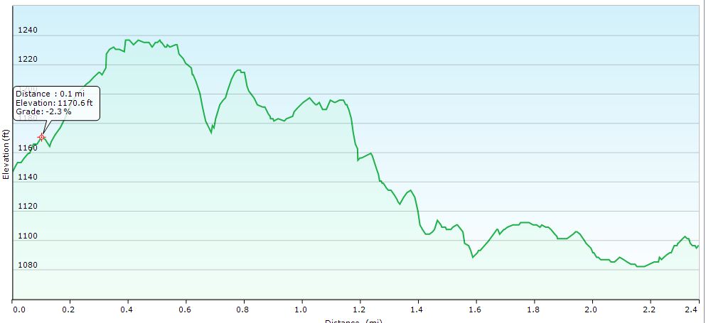
Distance: 2.4
Duration: 1:09
Elevation Rise: 223'


Description:
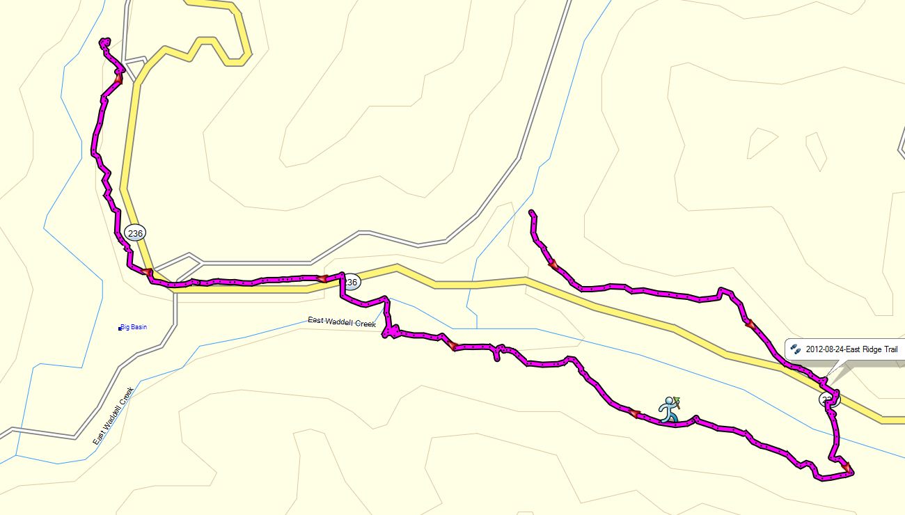
Team Thing One and Thing Two did the Sequoia Trail Loop which connects, in our case, three trails together: The Sequoia Trail, Shadowbrook Trail and we mistakenly took the East Ridge Trail to get back to the Park Headquarters. This description is for the East Ridge Trail and the Use Trail between Blooms Creek Campground the Park Headquarters.


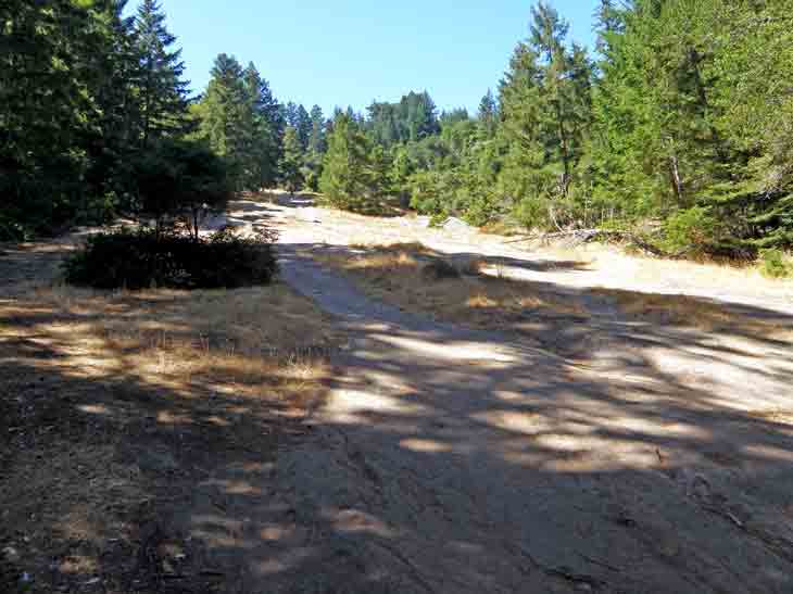
But have you ever noticed that a lot of times, one mistake can lead you on to a new adventure? That is what happened here. We got onto the East Ridge trail which then started paralleling Highway 236. We travel on this until we hit a wye where we had the option to continue up the ridge trail or cross the highway. We crossed the highway and Blooms Creek and then ascended a small slope. At this point we were at the edge of Big Basin. How did we know this? A sign said private property, but the trail turned into a dirt jeep track going westward. So we followed that, enjoying more of the walk. After about two-thirds of a mile, we hit a trail junction to Blooms Creek Campground. From here we knew what to do. Blooms Creek Campground is one of the few campgrounds where you can actually camp amongst old growth big tree redwoods—it is someplace for us to come back and camp someday. From here we grab the Use Trail and follow the highway to the Redwood Trail. We will grab this one another day as it is getting a bit late and we need to head back to Fresno tonight. We get back to the car around 5:30pm. Then it is back to Fresno we go. But not before a quick, be delicious stop at Marianne's Ice Cream.


Adventure 008, Hike 061 - Shadowbrook Trail

Capture California, the Game-2012
Adventure: 008, Hike 061 – Shadowbrook Trail
Team: Thing One, Thing Two
Date:  August 24, 2012
Location: Big Basin Redwood State Park
Hike Info:
Trail: Shadowbrook Trail – From Slippery Rock to Sempervirens Campground
Distance: 2.1
Duration: 1:07
Elevation Rise: 254'


Description:
Team Thing One and Thing Two did the Sequoia Trail Loop which connects, in our case, three trails together: The Sequoia Trail, Shadowbrook Trail and we mistakenly took the East RidgeTrail to get back to the Park Headquarters. This description is for the Shadowbrook Trail.


Around Slippery Rock and the Founders Monument, the Sequioa Trail heads off towards the Skyline to the Sea Trail. But it is also the start of the Shadowbrook Trail. Just beyond Slippery Rock, is the Founders Monument. In 1900 San Jose artist Andrew Hill took a group of local influential men to this place and here the Sempervirens  Fund was created, which eventually led to the creation of Big Basin State Park and the entire California State Park system.  They camped at Slippery Rock and would go to the Sempervirens Falls to admire its beauty. Slippery Rock is about 200 yards long and rests at a 30 degree angle.


We continue north and eastward along the Shadowbrook Trail, for a short distance, it then crosses the road and starts climbing up toward Sky Meadow Group Campground. The trail is also the path for the sewer. This is the literal high point of the loop we are doing. The trail then starts a steep descent into Union Creek—it is much better to do this loop clock-wise as the climb is more gradual. But either way, hiking among the old growth redwood forest is wondering. The afternoon light is filtered through the tree branches onto the greenery surrounding the trail. Once we make it down to the creek, it weaves it way under logs and bush to re-appear. We pass by named redwood groves. We make it past a couple campgrounds exits, including Sempervirens Campground and the Bob Kirch Trail. This last one is a couple hundred yard trail back to the Sequoia Trail. The first is about a third of a mile down and would lead us around to the use trail back to park headquarters. But continue on for the next adventure to see what happened.


Adventure 051, Site 185 – Big Basin Redwood State Park

Capture California, the Game-2012
Adventure: 051, Site 185 – Big Basin Redwood State Park
California Landmark Number: 827


Team: Thing One, Thing Two
Date:  August 24, 2012
Location:
Latitude: 37° 10.932′ N
Longitude: 122° 12.576′ W
Address: Slippery Rock Memorial, Big Basin Redwood State Park

Description:
In August, before we realized we could have multiple landmarks, we paid a visit to Slippery Rock and the Founders monument, when we walked the Shadowbrook Trail. These monuments have a tendency to make the team think about what we have and what could have been lost if people like Andrew Hill had not stepped in. Without his group, Big Basin would not have been created. Without Big Basin, the State Park system may not have been.

In writing up this adventure, we noticed that a couple weekends ago, was Big Basin Founder's Day.


NO. 827 BIG BASIN REDWOODS STATE PARK - A group of conservationists led by Andrew P. Hill camped at the base of Slippery Rock on May 15, 1900 and formed the Sempervirens Club to preserve the redwoods of Big Basin. Their efforts resulted in deeding 3,500 acres of primeval forest to the State on September 20, 1902 to mark the beginning of the California State Park System.
Location: Slippery Rock Memorial, Big Basin Redwoods State Park, State Hwy 236 (P.M. 8.7), Big Basin


References:


Overall Landmark References:

Adventure 008, Hike 060 -Sequoia Trail

Capture California, the Game-2012
Adventure: 008, Hike 060 – Sequoia Trail
Team: Thing One, Thing Two
Date:  August 24, 2012
Location: Big Basin Redwood State Park
Hike Info:
Trail: Sequoia Trail-from Park Headquarters to Slippery Rock
Distance: 2.0
Duration: 1:00
Elevation Rise: 432'


Description:
You can go on three different routes with the Sequoia Trail. The first is straight out and back, the second is to connect it with the Skyline to the Sea trail, or the third is the longer connection with the Shadowbrook Trail, which is the one we want to go on. Well, Thing One and Thing Two took on a fourth option, and that was to miss the cut off to the park headquarters and pick up the East Ridge trail. But more on that later.


Team Thing One and Thing Two did the Sequoia Trail Loop which connects, in our case, three trails together: The Sequoia Trail, Shadowbrook Trail and we mistakenly took the East Ridge Trail to get back to the Park Headquarters. This description is for the Shadowbrook Trail.


We were in Mountain View, visiting our parents when we decided that we would go back to Fresno via Big Basin. Big Basin has been one of those places we have enjoyed, but not visited enough. There are a splendid amount of hikes through some pretty big trees, in the cool coastal environment with mountain sides which are steep, but passable.


We get to Big Basin about 1:30 and start to hike pretty quickly after that. Your faithful scribe left a GPS on top of the car and needed to make a quick trip back to the car to retrieve it. The day is sunny and the temperature is moderate, low 70's. For us Fresnan's, it is cool--we welcome it.


Last year when we hiked the Sequoia Trail, we learned that it is one of the oldest trails in Big Basin, having its origins back in 1875. It was originally called the Rodger's Trail for one of the original homesteaders. This is a walk through an old growth forest in Big Basin.  The trail passes by several camp grounds, including the Wastahi Walk-In Campground, and comes close to the road on several occasions. The good side is about a mile and a third, there is a restroom which you can use. We ended this segment of the trail at Slippery Rock.  But before we get to Slippery Rock we made a side diversion to Sempervirens Falls. This Fall, when going well, presents a dreamy falls, under old-growth redwoods, with a fan-like fall. There was two things which spoiled this view: the falls were a mere fraction of its self and there was a sign at the base saying, do not stray from the trail.


Just beyond Slippery Rock, is the Founders Monument. In 1900 San Jose artist Andrew Hill took a group of local influential men to this place and here the Sempervirens  Fund was created, which eventually led to the creation of Big Basin State Park and the entire California State Park system.  They camped at Slippery Rock and would go to the Sempervirens Falls to admire its beauty. Slippery Rock is about 200 yards long and rests at a 30 degree angle.


Wednesday, June 20, 2012

Adventure: 013 – Cooking Like Davy Crockett

Capture California, the Game-2012
Adventure: 013 – Cooking Like Davy Crockett
Team: Thing One, Thing Two
Date:  June 20, 2012
Location: Big Basin Start Park
Description:


The Cat in the Hat really know how to cook over a fire. They are so good that at times they have taught others how to do the same. On this evening, The Cat and her friend Lyndsey fed her brother Steven a version of Hobo Pie. For this, our camp chefs used their REI Pie Irons. What they did was pretty simple—made a bread dough, then added mushrooms, vegetables and sauce. Then put the irons into the fire and waited until it smelled ohhh sooo good. Then they ate to their hearts content.