Adventure: 051, Site 054 -
McGurk Cabin
National Registry ID: #79000281
Added to NRHP 6/4/1979
Team: Thing One, Thing Two
Date: September 14, 2012
Location:
Latitude: 37°40′40″N
Longitude: 119°37′27″W
Address: McGurk Meadow Yosemite
National Park
Date Built: 1895 to 1897
Architect: Davanay,Hugh
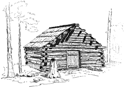
The McGurk Cabin in Yosemite
National Park was the seasonal home of Yosemite
cattleman John McGurk from 1895 to 1897. Located on the edge of
McGurk’s Meadow, just to the north of the Glacier
Point Road, the cabin was used by a series of
owners beginning with Hugh Davanay, from whom McGurk bought the
property in 1895. McGurk was evicted by the Army in 1897 after a
dispute over title to the land. The log cabin is a one-room
structure, about 14 feet (4.3 m) square, with saddle-notched
peeled lodgepole pine logs. The only opening is a low door on the
south side. The cabin was stabilized in 1958 by Sierra
Club volunteers. It is one of the few
structures left in the park that remain from the pre-park era.[2]
The cabin was listed on the National
Register of Historic Places on June 4, 1979.[1]
See Hike number 119 for Thing One and Thing Two’s hike description.
In looking at some of the NPS photos, it looks like this cabin is a few logs shorted than it was 30 years ago.
From an article on log cabins by Robert F. Uhite in the Sierra Club Bulletin, May 1951:
McGurk Meadows.—In McGurk Meadows, one mile west of Bridalveil Creek and about one mile north of the Glacier Point road, is the site of a stockman’s cabin similar in appearance and construction to the cabin in Mono Meadows. Lodgepole logs, notched on the under side only and about ten to twelve inches in diameter, were used to a height of four and a half feet for the walls, the base log being laid on the soil. Fireplace, windows, and flooring have been omitted. Wedge-shaped chinking filled the wide gap between logs. The doorway is four feet high. Shakes were used to cover the roof, which measured nine feet from eave to ridge.
This cabin was intended to have been part of the homestead of John J. McGurk, but through an error in description, the wrong property was filed upon. Thomas M. Again originally filed for the 160 acres intending to claim what is now known as McGurk Meadows, but the description entered into the county records placed the claim well up Illilouette Creek. Hugh Davanay subsequently acquired this mistaken title from Again, and sold to McGurk in 1895, who continued in possession until August 1897, when he was removed by U.S. troops, then the custodians of the national park. Their basis for this removal was the error in the original description of the claim patented by Again; the patent was for an area six miles directly east of his intended homestead. After his removal, McGurk forced Davanay to reimburse him for his loss and Davanay in turn tried to effect a trade with the General Land Office for the desired piece of land, but was refused. The land covered by the original patent was exceedingly rough and was considered worthless; Again could not dispose of it. Thus, McGurk
Meadows has always been in government ownership although occupied
pied by several persons over a considerable period of time.
In looking at some of the NPS photos, it looks like this cabin is a few logs shorted than it was 30 years ago.
From an article on log cabins by Robert F. Uhite in the Sierra Club Bulletin, May 1951:
McGurk Meadows.—In McGurk Meadows, one mile west of Bridalveil Creek and about one mile north of the Glacier Point road, is the site of a stockman’s cabin similar in appearance and construction to the cabin in Mono Meadows. Lodgepole logs, notched on the under side only and about ten to twelve inches in diameter, were used to a height of four and a half feet for the walls, the base log being laid on the soil. Fireplace, windows, and flooring have been omitted. Wedge-shaped chinking filled the wide gap between logs. The doorway is four feet high. Shakes were used to cover the roof, which measured nine feet from eave to ridge.
This cabin was intended to have been part of the homestead of John J. McGurk, but through an error in description, the wrong property was filed upon. Thomas M. Again originally filed for the 160 acres intending to claim what is now known as McGurk Meadows, but the description entered into the county records placed the claim well up Illilouette Creek. Hugh Davanay subsequently acquired this mistaken title from Again, and sold to McGurk in 1895, who continued in possession until August 1897, when he was removed by U.S. troops, then the custodians of the national park. Their basis for this removal was the error in the original description of the claim patented by Again; the patent was for an area six miles directly east of his intended homestead. After his removal, McGurk forced Davanay to reimburse him for his loss and Davanay in turn tried to effect a trade with the General Land Office for the desired piece of land, but was refused. The land covered by the original patent was exceedingly rough and was considered worthless; Again could not dispose of it. Thus, McGurk

[click to enlarge] McGurk cabin |
References:
- Wikipedia
- National Historic Registry-Documentation
and Photo
Overall Landmark References:
- Wikipedia: California's
National Landmarks (WCNL)
- State of California Historical
Resources (CHR)
- National
Registry of Historical Places (NRHP)


No comments:
Post a Comment